The River Alt flows north east through Lancashire and Merseyside. It rises in Huyton township at the Hag Plantation, and flows through Croxteth Park, West Derby and Maghull. It then flows out to the River Mersey
between Crosby and Formby. St Helens Gutter, as the Alt is known between Aintree and Maghull, was once the name of the Milldam (water supply) of Sefton Mill. The Milldam was once located near Sefton parish church.
The river flows through a channel created around 14,000 years by glacial ice which crawled south from the Irish Sea basin. The ice moved up the Alt channel, across the slightly higher ground which now makes up the north side of the Mersey. It flowed back down towards the Cheshire Plain along the channel of Ditton Brook. As a result, Ditton Brook and the River Alt now flow back-to-back.
As the Alt flows towards the coast, it cuts a channel through a plain of alluvium (river or wind deposited sand), mudstone and sandstone. At its mouth are the wide beaches and quicksand of the west Lancashire coast.
River Alt archaeology
Along the banks of the River Alt are a string of settlements with names suggesting a Viking origin. Huyton, Croxteth, West Derby, Knowsley, Aintree, Maghull and Formby are the major examples. At one time, it may have been possible to bring boats as far as three miles inland up the Alt. If so, it would have been a convenient way for settlers to come inland to found new hamlets.
For generations, people have had to fight against the Alt flooding. The 1779 Alt Drainage Act tried to deal with this, straightening the winding, flood-prone course of the river. The word ‘Altmouth’ is shown on both Caxton’s and Speed’s maps, where the river empties into the Mersey. It has been suggested that this settlement was swept away by the unpredictable movements of the river. However, there was never a ‘village’ symbol shown on any maps, and no evidence for such a village exists. Indeed, the area is still generally known as Altmouth today.
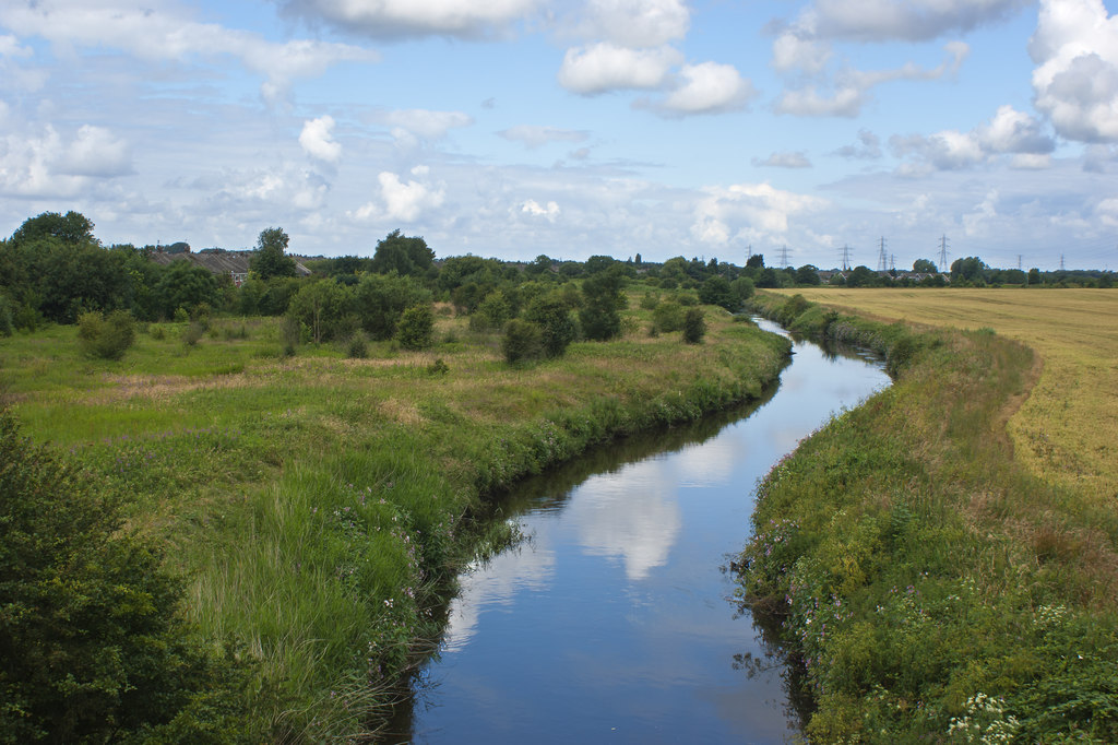
Today the Alt valley is a protected nature reserve. Twenty miles of embankments protect the farmland which lies either side.
Image: SJ3898 : The River Alt from the aqueduct carrying the Leeds and Liverpool Canal, released under a Creative Commons license.
Further reading
River Alt – from Sea to Source, by Peter Sinclair (Youtube, accessed 19th November 2017)
Larraine Leonard
I spent many a day in the summer holidays trawling this little river. Never realised that it was so important. I thought it was just a little creek.
Gerry Hill
I can remember swimming in The River alt and running alongside it to get dry when I was a child. I would like to start a Friends ofRiver Alt Society and would welcome any volunteers or donations to get this project off the ground. Please feel free to contact me if you feel that our environment would benefit from this scheme.
Martin Greaney
Hi Gerry,
That sounds like an interesting idea. If you do manage to get a team together do let me know and I’ll do my best to help spread the word!
Martin
Jackie
The River Alt exits at Hightown on Merseyside, which is now Sefton, Merseyside, not West Lancashire. There also has been found at Hightown evidence of Anglo Saxon dwellings which you can see at Museum of Liverpool.
Martin
Hi Jackie,
Thanks for highlighting the Hightown evidence in the Museum. Well worth a look!
You’re right, Hightown is not West Lancashire, I was being a bit lazy really calling it the ‘west Lancashire’ coast. 😉
Martin
phil newton
I ve just done a days trace walk of digs made since 1981 led by L/pool museum Archaeologist on the Alt from Huyton[Tarbock ] to Altcar with evidence of hunter gatherer settlement sites of 6K BC-most important in Europe.
phil newton
Mark Fethney
Thanks, an interesting bit of history of my local river (Kirkby). Does anyone know if the river is navigable in an open 15ft canoe?
Andy Bruce
When we were kids (50yrs ago) the Alt was filthy and it was said that 3 sewerage farms emptied into it, don’t know how true that is, but it is nice to see it cleaner looking now.
We used to cross it using one of those pipes that go over it near the old Roan. They were only just building the motorway then. If we had slipped off I dont know what we would have done. I remember that a dog jumped in once and died about a week later because of the poisons that it swallowed. Does anyone remember ‘the clondyke’ where the alt goes under the Leeds & Liverpool canal
Mick Caddock
Interesting stuff , Im also thinking id like to try and canoe down the Alt , I think its clear most of the way upto Altcar , anyone ever done this ???
Clive
I once floated with one or two friends on a rather large expanded polystyrene block, from the Cork Factory at Formby all the way to Hightown. We got off before the weir, of course. After that the Alt heads rapidly into the estuary with mud flats either side.
Martin
Hi Clive,
I love it! The things we got up to when we were younger… Glad you got off before floating out to sea.
Martin
VAL BROOKFIELD- BISHOP
AROUND 1965 I WORKED AT THE MERSEY AND WEAVER RIVER AUTHORITY IN GREAT SANKEY AND THE RIVER ALT WAS UNDER THEIR AUTHORITY TO MAINTAIN WITH REGULAR ‘ENGINEER INSPECTION’. FOR THIS PURPOSE, ACCOM. WAS NEEDED AND I DESIGNED THE BACK TO BACK BUNGALOWS FOR THE SMALL SITE IN ORDER THAT PERSONNEL COULD ‘STAY OVER’ IF NECESSARY IN CASE OF PROBLEMS.
DOES ANYONE KNOW IF SUCH BUNGALOWS ARE STILL THERE/ AS I AM NOW ALMOST 76, I WOULD LOVE TO HEAR FROM ANYONE WHO MAY KNOW OF SUCH HOUSING.
Mark Cox
I did some brief research on ‘Tue Brook’ which flows into the Alt. Apparently this brook (which runs alongside my sisters house) is mentioned in the Doomsday Book but I have yet to verify this.
JOHN MCDONALD
I was born in house in Altmoor Road, Huyton. This River is intrinsically linked to my entite childhood. The River emerged on the land below Huyton Village. There were the remnants of an army camp at Blue Bell Lane. It was basically a land drain for the extensive farmland around Huton Quarry. I recall a schoolmate, Jim Lynch, doing some research which determined that Huyton was built on a “col” and had indeed been navigated from the Mersey by the Danes. (Vikings). As kids we would build dams across to create hige swimming pools, into which most of the kids would skinny dkp for hours on end. When they trams became defunct the line to Prescot was taken up. Many of the sleepers fuelledocal fires but resourceful kids carried enough to block a bridge completely. The fun lasted for several hours as levels rose. Next day the River was over the top banks and ooding the fields. Thefe were hundteds of kids swimming and diving off the bridge. Of course ed had no idea that the farms down stream depended on this for their animals. Quite a fuss ensued whilst yhe dam eas temoved nbit we were all warned to keep the water rinmimg. It eas amazing when they released the water. As kids we had no odra of the power of a fam burst but I can still picture that eayer ishinh through yhe bridge. It was scary. However we had nmanaged to eash oit alll the dead dogs and cats, but a stern warning had its effect
David bamber
Does anybody remember a children’s park near the alt ,off or near altmoor road huyton in the 1950 ,if you do please let me know ,as it would settle a discussion I am having with my sister bake off flo .thanks everybody .
Dave Wilson
I remember helping to build a dam over 60 years ago where the River Alt passes between the border between St Dominics playing field, and Cantril Farm when it was farm land. Occasionlly we would take some cale or a turnip from the farmers field and eat them raw, but not too much. I still think back to those days, maybe a couple of times a year, when we would fish for Sticklebacks in a pond on the farm land and play in one of the several woods. I don’t remember a farmer ever chasing us.
The dams we built would create a back swimming pool at least 5ft deep and the big lads got hold of a builders plank and dug a space out of the hill side so we could have a diving board. When diving into the water, it had a strange effect on our nostrils that one does not get from sea water or public bath water, somehow I think fresh water does that to the nostrils so probably it was not just the Alt water.
On two occasions I was told that a farmer(s) from down stream had breached the dams because the animals needed the water. If the Alt was contaminated I don’t remember anyone ever getting sick from it. Also, why would they allow animals to drink from it if that was the case. All through my life I have never forgotten those days as a kid and the numerous times we played along the banks of the Alt- our huckleberry freind.
John Smalley
Anyone know of the locations of ancient fords across the Alt around Aintree or Sefton.
John Smalley
Do you know of the sites on any ancient fords across the Alt ?
David Wilson
Nearly 70 years ago we also swam in the Alt where it travells past St Dominic’s school playing field. We dammed the river with soil and the water level got to about 4-5ft deep. We also had a diving board, engineered by the bigger lads, by digging a hole into the hillside beside the river and fixing a plank into it gratefully borrowed from a building site. I believe it was the farmer(s) from down the river who breached the dams after about a week when realising the flow of water had stopped. Theres something about freshwater that creates an unusual sensation in ones nose I found. The river Alt and adjacent farmers fields, woods and ponds were a playground for us kids and I still think about those days. I wonder if sky larks still fly above that area?
R P HUITT
at the age of 7 in 1950 my brother and i & mother lived in the sand dunes at Hightown, on an old boat with the cockpit covered with a tarpaulin, just about where the river ALT, entered the Mersey. We were allways in it, crossing to Formby bank. After a few years on the boat, we moved on to the Altcar rifle range with the Alt running behind our house, and sometimes canoed up the alt to Formby, also saw the troops build a baily bridge across it behind our house. Before we lived on the ” boat ” we lived in west Derby just near the river ALT. For the last nearly 60 years i’ve lived in Hull, but have never forgotten my lovely childhood on the west coast and the great RIVER ALT, You can probably tell, with me being on this site, how much the wonderful river ALT means to me. R P Huitt, 19 03 2024