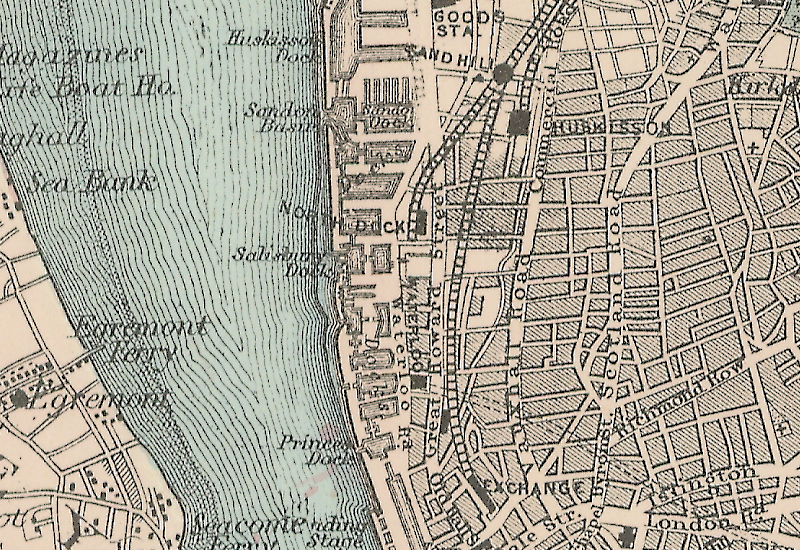
When reading about Liverpool’s ever-expanding dockland landscape, you can’t help but be drawn into the technological advances. These too helped create the dock landscape we see today.
The map here is of the northern docklands, specifically Waterloo (1824), Victoria and Trafalgar (both 1836). They were built at the beginning of the age of steam ships by the dock estate engineer Jesse Hartley, and so had a couple of new considerations to take into account.
Firstly, the gates had to be wider, as the early steam ships were not only larger vessels but had a paddle wheel on each side. Secondly, Hartley made the simple choice to build them with their narrow sides parallel to shore. Whereas earlier docks maximised acreage of water and were square or rectangular in shape, the new docks maximised quay length instead. Building docks jutting out into the river reduced the length of shoreline taken up by docks (so keeping space free for future development) and allowed the architect to use as much river space as he needed to fulfill his ambitions.
So looking at Bacon’s 1885 Map of Liverpool above, compare the narrow lengthways docks (from Princes Dock southwards to Liverpool’s centre and beyond) to the newer, bigger, more modern docks at right angles to the shore, starting at Waterloo in the north. Even further north you can see the map shows that quay length was taken a step further with the building of several branch docks on the likes of Huskisson and Brocklebank.
[As a postscript, later maps (such as the Royal Altas of England, 1898) show how Waterloo was altered to have an East and West basin, although a long quayside was still important – hence the division down the middle.]
Waterloo, Victoria and Trafalgar are the three docks, south to north, with the words Docks written across them in the middle of the map.

Mary
says:Thank you for this! I’m a writer researching Liverpool historical docklands and this is very helpful.