This site often talks about the role played by Liverpool’s geography throughout history. From the location of the ancient Calder Stones (wherever that might have been) to the collection of banking institutions on Castle Street, Historic Liverpool and the book Liverpool: a landscape history have tried to communicate the importance of positioning to the development of the city. Western Approaches is a case in point.
Such factors work on different scales, from the very local to the global. It’s no surprise that, during an event we call a World War, a city can live or die based on it’s global placing during the conflict.
In one sense Liverpool could be seen as lucky. It was on the far side of the country to the main enemy Germany, and flight technology was only very recently up to the job of getting planes over such long distances to drop bombs. Unfortunately, however, our city’s status as the premier port outside London made it a target worth fighting your way across the Channel and England to get to and attack. Countless innocent people found this to their ultimate cost.
So landscape keeps the enemy at bay, and at the same time draws them to you.
But being on the west coast of Britain also put Liverpool in a key position regarding the importing of food and other raw materials into the country from across the Atlantic. And when Europe and the Channel become dangerous to shipping, the European Allies’ reliance on New World trade only increased.
Liverpool was not just a target in its own right, but was the natural place to defend ships at sea in the Atlantic. And so in 1941 “Combined Operations” – responsible for defending the area of the Atlantic known as the Western Approaches – was moved from Portsmouth to Liverpool, to Derby House in Rumford Place.
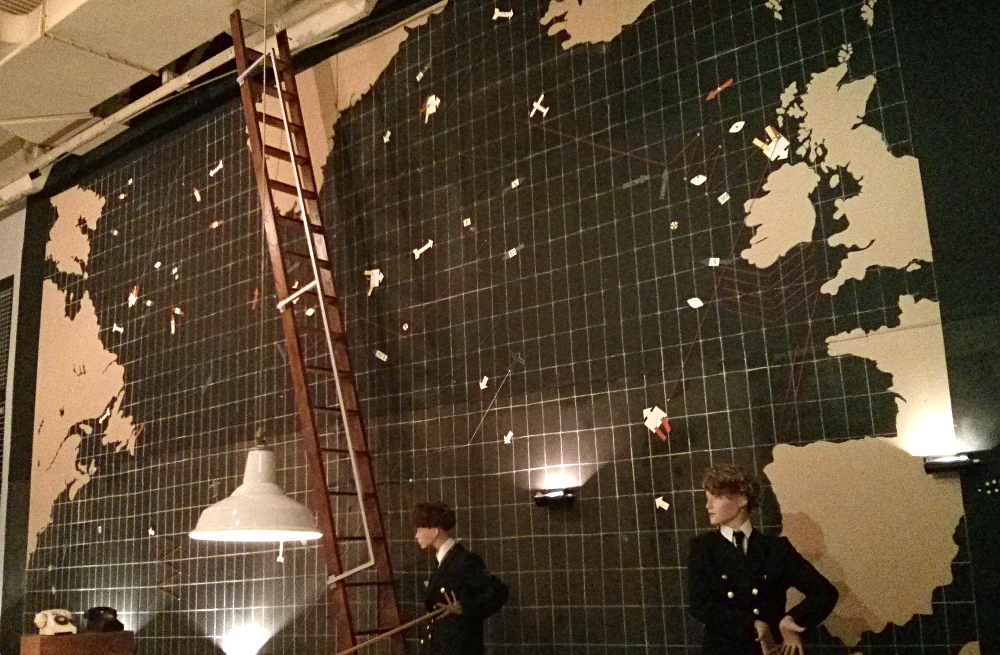
The story of the ‘Citadel’, or ‘Fortress’ is a story for other websites to relate, and for the Liverpool War Museum to show. However, we’re interested in maps here, and so I present the largest map you’re ever likely to see on this website, to go with perhaps the largest ‘landscape’ factor in Liverpool’s historic importance.
This was the Western Approaches map room, where teams of WRNS and WAAF personnel monitored the positions of Merchant Navy convoys through constant communications. Information on the enemy was passed back to British ships and Whitehall through secure direct telephone lines. Even the captured Enigma decoding device lived in the Citadel, messages being passed back and forth between Bletchley Park and Merseyside.
The map in the above photo is the Aircraft State Board, showing the positions of planes as they cross and patrol the Atlantic. The readiness of RAF stations in Britain could also be posted here.
The map below, on a table in the centre of the room, is the Situation Map. This is dotted with markers tracking ships, convoys and enemy U-boats.
In the days before the widespread use of computers and monitors, this was all updated by hand, the staff climbing the ladder and moving the parts on the Aircraft State Board like television weather forecasters of the mid-century. The table map can be seen being updated by a mannequin with a long pole to push the wooden pieces around. Tragically, the Museum informs us that one woman slipped to her death from this ladder, the only casualty of the war in this fortified bunker.

I became interested in historic maps because of the clues they give into the past of our familiar areas. The maps in Derby House give very little information in themselves, but were constantly updated with information about the ever-changing situation during the Battle of the Atlantic. Today, computers, Global Positioning Systems and automated algorithms would take care of this, with a handful of caretaker staff to keep it running smoothly. And yet it makes me wonder about the level of knowledge the WRNS and WAAF would have had at their disposal.
Their knowledge would have been intimate, up to date, yet vulnerable to human error. But these maps were the tools allowing them to communicate this information to each other, to work as a team to protect the vital systems which kept this country going throughout hostilities. Perhaps never have so many lives depended quite so thoroughly on so few maps.