1890: Plan of Liverpool – North Sheet
This is the north half of a detailed plan of Liverpool published in 1890. It is incredibly detailed, showing every road name, paths within the parks, and even individual buildings in some streets (where those buildings were big enough).
There’s also an index to road names down two sides, making it easy to look up a place of interest.
It’s a partner to a South Sheet, also available on Historic Liverpool. There are also concentric circles showing distances from the Town Hall, each one quarter of a mile apart.
It shows the densely packed city layout at the height of the Industrial Revolution, when Liverpool was experiencing unparalleled levels of immigration from other parts of Britain and beyond the country’s borders. Details of large thoroughfares such as Scotland Road and Erskine Street can be seen in their pre-war state, before extensive redevelopment changed the face of Liverpool forever.
Because of the high level of detail, the map only covers an area from Crosshall Street to Kirkdale Station, but this is one of the most important areas of Liverpool at this time in its history.
137 Comments on “1890: Plan of Liverpool – North Sheet”
Comments are closed.
donald macsween
Hi There
is there any possibility you could help me identify where Vesuvius Street was in Liverpool. I see the modern version of that name is off the Scotland Rd, but did it replace the old Vesuvius Street? I am trying to help my wife’s family understand where they were brought up. Sorry if this causes any inconvenience. Many thanks
regards
Don
Martin Greaney
Hi Donald,
No inconvenience at all – I love this kind of question! There’s a great site called the Liverpool A-Z, which is great for finding old roads, and shows the old version of Vesuvius Street in the same place as it is now, but with a lot more of the ‘grid-iron’ style of roads around it. Some, but not all of the old roads are still there, with the same names. The only confusing thing to remember is that on the old map north is to the left. Hope this helps, and do have a browse around the Liverpool A-Z!
Regards,
Martin
tracey
Hi, I am from Sydney Australia and I am trying to find 12 Trafalgar Street, Liverpool or Everton, on my g,g,g grandparents wedding certificate it states Sarah came from Everton Liverpool, is Everton a suburb of Liverpool? I have heard there is an old map of Liverpool with maybe Trafalgar St on it, can you help in any way. They were married in 1831 the year they came out to Australia.
thanking you,
Tracey
Fiona Jackson
Hi, I’ve found your comment when looking for 12 Trafalgar Street, liverpool which is the census address for my great great grandparents in 1890! Did you ever find it?
derek palin
yes Tracey it ran off Russell Street towards Trowbridge Street paralell to Brownlow Hill would be regarded as city centre now.
http://www.liverpoolhistoryprojects.co.uk refers liverpool az/streets T
Its obviously been demolished but if you look on street view you can see where it would have been. Good luck
Lynne Lay
Any idea where Lambert St is. It occurred on 1881 and 1891 census .
Thanks Lynne
Martin Greaney
Hi Lynne,
Lambert Street used to go through the site now occupied by Tesco on London Road (north side). It now turns east to meet Craven Street. You can see it on the lower half of this map at: Plan of Liverpool (South Sheet) 1890.
The modern street can be seen on Google Maps.
Margaret Morrison (nee Edwards).
Hi, I am writing from Melbourne Australia and am tracing my Family Tree. My Great, Great Great Grandfather appears on the 1871 Census as living in Dinorban Street. I have not been able to find it on any current map. My G, G, G, Grandfather and family also appear on 1861 Census as living either a Cillar Street or Cellar Street. This address is in the parish area of West Derley and the Ecclesiastical District of St Clemont. Any help of the location of either of these address’ would be a great help. Thank you,
Margaret.
Martin Greaney
Dear Margaret,
Thanks for your message – it’s great to hear that this site is enjoyed from across the other side of the globe!
Dinorben Street was in Toxteth, to the south of the city centre, and just north of the still-existing Parliament Street. You can see Dinorben Street on the 1890 Plan of Liverpool here (it’s right on the vertical black line). These days it’s covered by industrial units, and can be seen on the History of Toxteth page here (scroll down to the map).
West Derby is a large parish based around the village of West Derby to the north east. It covered much of Liverpool along with the other parishes of Liverpool, Childwall and Walton-on-the-Hill.
Hope this is of some help!
Martin
Les Giblin
Hi margare I was born in dinorben street in 1955 and there
Was a long established Morrison family living there up until around 1960
Hope this helps they moved about 8 miles to hunts cross Liverpool
Sarah Wenham
Can you help me find out where Evans Street Liverpool was i think it was in the vauxhall area its not in the A to Z i am tracing my family history and my dad used to live there. thanks
Sarah
Martin Greaney
Hi Sarah,
A couple of people have been looking for this street. It must have been a very small street, as it is unmarked on some maps. It was in the block north of Tatlock Street, and on the below map this can be seen under the final ‘D’ of Scotland Ward. I’ll let you know if I find a more detailed map which actually shows the road itself.
Map: Plan of Liverpool (South Sheet), 1890, centred on Evans Street.
Best wishes,
Martin
Sheri Bly
Can you tell me what type of housing was on Doon Street in 1901? My grandparents, Matthew Barr lived at 1 Doon St and Jane Matthews lived at 2 Doon St in the 1901 census. Thank you.
Martin Greaney
Hi Sheri,
Doon Street, in Kirkwall, was part of the large area of terraced housing in north Liverpool. The houses were uniform, with small yards behind, and the streets were laid out in a grid pattern. They were built for the large number of working class people (dockers, labourers etc) who worked in the city. I think they were a definite step up from the slum court houses of the city centre, but the council saw fit to demolish them in the middle of the 20th century, and the area is now covered with modern semi-detached houses.
Here’s a map from 1890, with Doon Street circled in blue: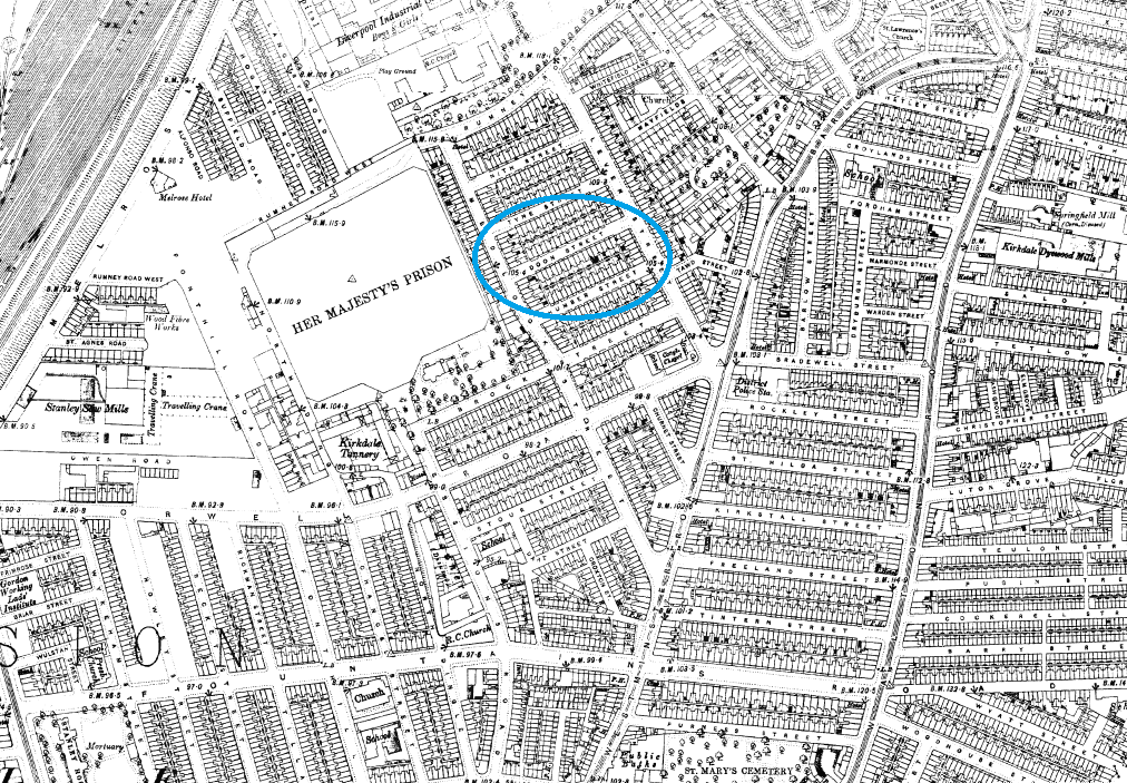
Abi
Hello, I don’t know if you’re still looking but I found this photo on a Facebook page of doon street, it’s from the 70s but I hope this helps 🙂 https://ms-my.facebook.com/LiverpoolPicturebook/photos/doon-street-kirkdale-1972/1441125882642334/
Sheri Bly
Hi Martin, Thank you for a description of the housing and the map. I had been able to determine where Doon Street was but the only thing I knew about the area was from my mother who said it was tenement housing. Matthew Barr was a refrigerated engine driver according to one census. Can you tell me anything about this occupation?
Are there any pictures that exist of Doon Street between 1891 and 1911. The Matthews family lived at 2 Doon St in 1891 and 1901 and the Barr family lined at 1 Doon St in 1891, 1901, and 1911.
Thank you
Martin Greaney
I’ve not come across any pictures of Doon Street, but I’ll let you know if a photo of that area shows up.
I presume a refrigerated engine driver would refer to something similar to today’s good vehicle drivers. The vehicles would be a lot less sophisticated in those days, with a compartment filled with ice, plus the chilled goods (fish? ice cream? 🙂 ). I don’t know whether ‘engine driver’ suggests he was on the railway or not. Perhaps he worked on the docks transporting ice and goods around the river front. A very intriguing job!
Martin
Dermot
Do you know the location of Broom Street ?
My great Grandparents married in St Alban’s RC Church 1891 with address given as 5 Broom St.
Maith thu,
Dermot.
Martin
Hi Dermot,
I’ve not been able to find a Broom Street in Liverpool, though there is a Brook Street, not far from St. Alban’s church in Vauxhall. Could the address have been mis-transcribed in one of the records?
Martin
Dermot
Many thanks Martin- much appreciated.
I will try and ascertain if error had been made with the street name.
Katie
Do you know the location of Argos Road and any information regarding shops during 1910 as my gr-gr-gr-grandfather owned a shop here.
Martin
Hi Katie,
It’s still in existence, although it’s very short, and can be seen here: https://goo.gl/maps/MXJtp6mzQW82
Martin
bill sanderson
I am trying to locate McKee Street. It is not shown on either the modern map or the 1901 A to Z. I have heard it ran between Scotland Road and Cazneau Street, near Juvenal Street. Can you help? Is there an on-line map showing it?
Martin
Hi Bill,
I don’t know if you’ve already found something, but here’s an old map with McKee Street on it: (see bottom left of map). It’s right where you’d heard it was, near Scotland Road!
For more of that area, my interactive map of Liverpool shows the road, un-named, running between Lawrence Street and Juvenal Street in the middle of this 1898 map of Liverpool.
Martin
Allan Purcell
I am looking for a pre second world 2 map with the house numbers on it. Does anyone know of such a map of Liverpool.
Regards,
Allan.
Martin
Hi Allan,
The earliest Ordnance Survey map I know of with house numbers is the 1950 one, so any pre-war map with them on will be from another publisher. I’ll let you know if I find one, though I don’t know of one so far.
Martin
Martyn
Hello.
I’m trying to find any existence of Somerville Street in Liverpool where my ancestors lived. I’m expecting it to be in the Kirkdale area. However, I can find no mention of it on neither of these maps nor the Liverpool A-Z. Any help you could provide would be fantastic.
Martin
Dear Martyn,
I’ve been sent a very useful map by a man named Phil D. Hopefully these will help your research!
Regards,
Martin
DEREK MARSDEN
I am trying to find Hutton street.It appears on the 1891 and 1901 census.It was probably neat the docks or a sugar refinery
Martin
Hi Derek,
You’re right, it was not so far from the docks, in Bootle. You can see Hutton Street on my map of Liverpool in 1890, it’s off Athol Street, the unlabelled road running down from the point between the I and N in “Hankin Str”. There’s a more detailed, labelled version, of Hutton Street on Old Maps.co.uk (you may have to zoom out when you arrive on that page).
Best wishes,
Martin
Kate Rowlands
Hi,
Would you be able to tell/show n a map where Nottingham Street, Everton would have been please? I had relatives there circa 1898 and earlier at Rose Vale but have been unable to locate it,
Thanks,
Kate
Martin
Hi Kate,
Nottingham Street is very close – in fact parallel – to Rose Vale. You can see Nottingham Street on my map of Liverpool in 1890. It’s unmarked, but it’s the street parallel to the north of Mazzini Street.
Best wishes,
Martin
Nancy
Hi Martin ,
What a great site -i’ve just found it because i’m trying to find info on a street i have found on a Mcert from 1885 .
Have you heard of ” BARKER St ” , it is clearly written as that but i can’t locate where it was .The marriage was at St Silas Church so might perhaps be in that parish ?
Martin
Hi Nancy,
I can’t find any information about Barker Street. I wonder whether it’s a mistake on the part of the person who wrote that entry on the certificate (though probably unlikely on a marriage certificate!). There’s a Barker Street on the Wirral, but I think I’m grasping at straws at this point. Sorry not to be of more help.
Martin
Stan
Hello Nancy, I expect that you have found Barker Street by now. If not then I can tell you that I found it while searching for the deaths of two of my tree. I went to ‘ search old street names’, entered Barker Street and was presented with a map with a circle over the street. It is very close to Edge Hill railway station. Hope this helps. Stan.
Sara Dubiard
Hi Martin, I’ve been trying to find Sandy Lane in Walton, my Great grandfather lived at number 65 in 1870s . Wondered if you could help ? Kind Regards Sara
Martin
Hi Sara,
Sandy Lane is in the north part of Walton, and is still there today. An old map from 1893 is available from here: https://www.old-maps.co.uk/#/Map/336946/396919/12/101394, while the modern Google Map shows it here: https://goo.gl/maps/LSYgoP3Mpm72 (though note that the numbers may have changed since 1893).
Hope this helps!
Martin
David Chaffin-Power
Hello Martin, just found your site and impressed with the amount of information you pass on to aspiring Family Researchers…. I hope you can help me with a street called Mordan Street in Liverpool. It featured in 1871 Census and my great grandfather and family lived there at the time. Any help will be greatly appreciated.
David.
Martin
Hi David,
I’ve had a little look but not having much success finding Mordan Street. There’s a Morden Street, which is still there in Kensington, but this wasn’t built until the 20th century so wouldn’t be on the 1871 census. Are there any other clues as to the location, such as where relatives lived which might be nearby?
Martin
David Chaffin-Power
Hello Martin and thanks for your response. On the 1871 Census Mordan Street is shown as being in the Civil Parish of Kirkdale, the Municipal Ward of Everton and District 113. Don’t know if this narrows it down but at present I don’t know of any relatives living nearby.
Many thanks again.
Frances O'Connor
Mordan Street is were my ancestors are from it is off Derby Road BOOTLE, between Bankfield street and Brunswick Place which can be found on a present day map
Martin
Hi David,
I can’t find many clues to where Mordan Street is. There are a few references to the place, but no clues as to exactly where it is. This link will take to the place on the map centred on Kirkdale. It’s north east from where the two trainlines converge. Mordan might be an un-named street on this map, eg. one of the smaller ones. https://historic-liverpool.co.uk/old-maps-of-liverpool/plan-of-liverpool-north-sheet-1890/#3/77.58/-74.53
Andrew Hunter
Hi I am looking for Canada Place Kirkdale. G.G.grandfather was there in 1881 census any help would be greatly appreciated.
Thanks in advance
Andy
Sharon Bell
Hello,
I’ve been trying to find a street listed on the 1851 Census. The hand writing is not clear but it looks like Burgpelt or something similar.
Any thoughts?
Regards,
Martin
Hi Sharon,
Have a look at this list of street names and see if any could be a likely match: https://historic-liverpool.co.uk/old-maps-of-liverpool/plan-of-liverpool-north-sheet-1890/#5/70.474/-153.325
There are references there so you can see which square of the map they’re in.
Martin
Joseph HANLON
hi martin , your map of liverpool 1890 . shows standish street of great cross hall street. liverpool 3. were holy cross church stood. next to the church was the preist.s house . on your map of 1890 .its just a blank white peice of land . this was said to be HANLON COAL AND TINDER yard . which was donated to the church to build the preists house i have seen a map which stated .Hanlon coal and tinder. many years ago but i cannot find it now ? any help . many thanks . Joseph hanlon
Martin
Hi Joseph,
I’ve looked through my own maps, and the wonderful old-maps.co.uk but can’t see one where that white space is labelled. The old-maps.co.uk site has an 1891 map with the church on it, so the map you saw must be earlier than that. I’ll keep my eyes peeled in case another maps crosses my path. Very interesting history about the land donation.
Regards,
Martin
paul finley
Hi there, I am trying to locate the street my grandad was born in Liverpool and the only place I can see it listed is a webiste on google but when you click through it doesn’t work. The road is Eastwood Road and I think it was off wavertree road L15 if anyone can help?
Many Thanks
Paul
helen rowan
hi martin could you please help me locate orthall st in liverpool…thank you
Martin
Hi Helen,
I’ve not had much luck finding orthall. Could it be a misprint that is meant to say Northall Street? To be honest I’m not having much better luck with that but there are a few roads across England with that name, and that might give you a lead.
Martin
John Shaw
Try Northill street liverpool 8
John Williams
Could possibly be Old Hall Street
sandra sugden
Hi Martin. Have only just found this great site. How helpful it is. I noticed an enquiry in 2016 from Declan looking for Broom Street. My Grandmother came from there and it is a tiny street right next to St Albans RC Church, which is not noted on map. The next Street was Birch Street. A bit late I know but maybe of help for future queries.
Sandra
Martin
Thanks Sandra,
Hopefully Declan will see your comment and be able to spot it.
Best wishes,
Martin
Graham clark
Hi Martin i lived in September rd L6 facing an old laundry,i remember looking into yard and above doors was boys and girls do you know what it used to be.giant fund any info on it thanksgraham
Martin
Hi Graham,
Yes, it seems difficult to find information on it! The old maps show it marked as a laundry all the way back to 1891, when the area was only just being built up. The boys and girls signs are common on old school buildings, but I’ve never heard of the need to separate boys and girls in a laundry (unless they were going there to wash the very clothes they stood up in!). Perhaps it was intended as a school, but never used as one, or indeed there was some reason for boys and girls to use this establishment (and separately!).
Martin
Vicky
Hi. I’m looking for Penistone Terrace as my great-grandfather lived there in 1891. I can’t find it on current maps so I’m assuming that it’s been demolished. I think it was around the Scotland Rd area. Have you any idea?
Many thanks.
Vicky
Martin
Hi Vicky,
There was a Pennistone Terrace mentioned in the index to the c.1951 map of Liverpool that I have (soon to be on the website, but not yet). It’s not drawn on the map, but is indicated to be close to Townsend Street in Kirkdale. See Townsend Street on this 1890 map: https://historic-liverpool.co.uk/old-maps-of-liverpool/plan-of-liverpool-north-sheet-1890/#5/67.509/-106.458. As you say, it’s almost certainly demolished. Sometimes a “Terrace” was a row of houses within a longer street, so it might have been a part of Townsend Street, or one of the unlabelled streets in that map at the link above.
Martin
James O'Connell
Hi, if you look at Townsend Street, its near the bottom.
https://maps.nls.uk/geo/explore/side-by-side/?fbclid=IwAR277UrZ3zTk-64DJpZ9Ua9uMyUqBCX4nbut9an7mIuncvesE31gDTmHWbk#zoom=19.3&lat=53.42589&lon=-2.99628&layers=117746211&right=BingHyb
Janet
Hi,
I am looking for a Linden (Lyndon?) Street/Road. (West Derby?) Researching great, great Grandmother. Any help appreciated
Thanks.
Martin
Hi Janet,
The nearest I can find is a Linton Street which is in north Liverpool. This area could have been labelled as ‘West Derby’ depending on the record. I can’t find any other road with a similar name, but I’d be grateful if anyone else reading this can help out too.
Martin
Denice
Hello!
I have just bought a similar map, and was looking for the Anfield stadium, but I can’t find it.. even though it was built in 1884…
Any help is appreciated
Martin
Hi Denice,
Oh yes! I’ve never noticed it myself, but Anfield is not labelled. If you click on this link this page should re-load with the location of Anfield in the centre.
https://historic-liverpool.co.uk/old-maps-of-liverpool/plan-of-liverpool-north-sheet-1890/#5/74.776/3.713
It’s a pale empty rectangle bordered by the ‘-ELD’ of ‘Anfield Road’ to the north.
Martin
Dominic Wall
Dear Martin,
my wife’s family lived at Smollett Street off Kensington at the very bottom of the north sheet map and she is trying to locate an old photo of the street, before it was demolished in the 1970s to show to her mum as a prompt for memories. Would you have a recommendation for any sites that might be worth trying?
Many thanks,
Dominic
Martin
Hi Dominic,
For photos I’ll always recommend Liverpool Picturebook (https://web.archive.org/web/20210731092116/https://www.liverpoolpicturebook.com). I can’t find anything on Smollett Street itself but it’s worth trying to find streets nearby, as sometimes photos can show other streets in background or on the edge of them.
Regards,
Martin
David McCormick
Hi – I’m trying to find old photographs of Raymond Street (off Scotland Road) and Venmore Street (running up to Anfield).
These were early addresses for my wife’s parents but anything resembling 19th century photos have been impossible to find.
Hope you can help!
Regards
David McCormick
Martin
Hi David,
I’m afraid I’ve not found any photos in my usual sources, but if I do find some then I’ll post them here!
Best wishes,
Martin
Pauline Campbell
Hello Martin, what wonderful sources of information you and your site are! My father was born in Crown Court , Maidens Green which I know is off Highfield Street. These were slum court houses. Do you know of any map which shows the names of the individual courts? I can see that Maidens Green was at the Leeds Street end of Highfield Street. My father told me it was once where the captains used to promenade their lady friends.
Martin
Hi Pauline,
Thanks for your kind comments!
The courts off Highfield Street are marked on the 1:500 scale maps. The only one online I can find is here: https://www.old-maps.co.uk/#/Map/334195/390985/13/100871, but I can’t see Crown Court on there – they just have numbers (Court No1 etc). But hopefully it’s a pointer in the right direction.
Regards,
Martin
Bill Elder
Looking at 1890: Plan of Liverpool – North Sheet, there is an error in that it shows a factory at the bottom of Silvester Street, whereas it should show St Martins Cottages, which were built between 1864 and 1869 and were there until we moved out in 1955. I understand that these were the country’s first municipal housing. They are shown in the 1906 Ordnance Survey map of Liverpool North together with St Martin’s Recreation Ground, which replaced the cemetery on the other side of Silvester Street, and is still there.
Martin
Hi Bill,
Well spotted! I know these maps are derived from the Ordnance Survey ones, but inevitably there’s a delay. But I never thought the delay could be as much as 30 years! The Cottages can be seen on this map on the National Library of Scotland: https://maps.nls.uk/geo/explore/side-by-side/#zoom=17.603333333333328&lat=53.42148&lon=-2.98809&layers=168&right=BingHyb, and there’s a great article, photos and discussion on Colin Wilkinson’s Streets of Liverpool website: http://streetsofliverpool.co.uk/st-martins-cottages/
Best wishes,
Martin
Stewart smith
Good morning
I am trying to find out what I can about Wolfe or Upper Wolfe Street. My ancestors appear in the 1851 census in Upper Wolfe Street but, trying to locate other records, I can only find Wolfe Street on current maps. Upper Wolfe Street was probably quite long as house numbers went up to at least 191 but Wolfe Street appears to be just a tiny street these days.
Many thanks for such an interesting web site.
Martin
Hi Stewart,
Yes, it looks like Wolfe Street is a shadow of its former self! It used to be a much longer street, with strings of terraced housing on it – enough for there to be at least 191. But I can’t find an Upper Wolfe Street, even on the very detailed 1850 map, so I assume It was all labelled Wolfe Street.
You can see the street on my detailed (and searchable) street map here: https://historic-liverpool.co.uk/interactive-maps/old-streets-liverpool/#17/53.39003/-2.97519 or on the South Sheet counterpart to the map on this page here: https://historic-liverpool.co.uk/old-maps-of-liverpool/plan-of-liverpool-south-sheet-1890/#5/50.681/-49.197
Best wishes,
Martin
Anne Darracott
Wolfe Street, Liverpool 8, started at Hill Street, continued over Warwick Street, and ended at Northumberland Street, I lived at 171 which was last house before Northumberland Street. Then there was chippy that stood on corner of Northumberland Street.
Ursula Starr
Please could you tell the location of Dunkeld Street in Everton
Kind regards
Ursula
Martin
Hi Ursula,
Dunkeld Street was on the north side of West Derby Road. You can see it on the old map here: https://historic-liverpool.co.uk/interactive-maps/old-streets-liverpool/#17/53.41538/-2.95812 (that map also has a search feature). The street has been reduced to a cul-de-sac, and renamed Dunkeld CloseL: https://www.openstreetmap.org/#map=17/53.41584/-2.95968. (Google Maps labels a remnant part of the original road with the original name, but there are no buildings on it anymore).
Best wishes,
Martin
Chris Fleming
Hi,
I am researching the life of my great uncle, John Coffey, who died in France in 1918.
The 1901 census shows the family living in 2 Court No 5 Whitley Street. Do you know of any map showing where these houses would have been located, or how the courts were laid out?
I know at the time of his death he was living in Portland Street (now demolished) just off Vauxhall Road. Did Whitley Street originally extend all the way to Vauxhall Road? Any help would be greatly appreciated. Very best wishes.
Yours,
Chris Fleming
Martin
Hi Chris,
There’s a great map showing the courts on Whitley Street on the NLS maps page, which is extracted below. As you can see, Whitley Street never extended all the way to Vauxhall Road. Burlington Road (which still exists) is the street which you can see the beginning of to the right.
Best wishes,
Martin
Chris Fleming
Hi Martin,
Thank you so much for your helpful response, much appreciated! Very best wishes.
Yours,
Chris Fleming
George Millar
Hello,
I’m doing some research on a soldier who served in the Boer War and then in WW1. He lived in N° 26 McLeod Street which I believe was in the Domingo Ward of Liverpool but I haven’t been able to find the street on any map that I’ve looked at. Any chance you know where to find it?
Martin
Hi George,
McLeod Street was just off Breckfield Road South, and you can see it on my map of old streets here: https://historic-liverpool.co.uk/interactive-maps/old-streets-liverpool/#17/53.42136/-2.95942. There’s a search box in the top left corner which will pinpoint the spot for you, and highlight it with a red circle.
Best wishes,
Martin
George Millar
Hello Martin,
Firstly sorry for the delay in replying. Many thanks for finding the street I was looking for, much appreciated. However, I have another which I cannot find, it’s listed as “Nontenoy ?? Street” in the marriage record of John Tierney and Jane Mullin dated 19th January 1880. I had a look on the map you listed for me but it doesn’t register with it. Would you happen to know where this might be or am I reading it wrong in the marriage record. Sorry to bother you once again. thanks in advance.
Regards
George
Martin
Not a problem! 🙂 I think the entry probably should read ‘Fontenoy Street’, which shows up in the map search. I’m happy to help with things like this – search boxes will never be as good as human knowledge when it comes to difficult-to-read sources!
George Millar
Hi Martin,
Many thanks once again and for the quick reply. As you say, local knowledge is a big help. Once again, much appreciated.
Regards
George
Chris Yates
Hi
My Gr Gr Granfather is identified as living at 15 House, 1 Court, Warfield Street in 1881
The only thing I’ve found to confirm even its existence is a bride living at that address who was married at St Matthias’.
Can you throw any light on where it was, what sort of housing it was and if there are any plans/pictures of this or similar properties.
Thanks for any help you might be able to give
Martin
Hi Chris,
I think the street you’re looking for is Worfield Street, which has Court No. 1 marked as running off it on the 1891 OS map (see below). Worfield Street was close to Leeds Street, but the area has been heavily redeveloped now. You can see the area on my map here: https://historic-liverpool.co.uk/interactive-maps/old-streets-liverpool/#18/53.41219/-2.99129, which is a searchable map.
Regards,
Martin
Cal
Hi Martin
I wonder if you can help me. My gggg grandfather has his address on his child’s baptism record in 1827 as Crown Court, Highfield St Liverpool. Same address given on her burial record in 1832…. He was a printer by trade. Would this be the name of a court (courtyard) off Highfield St or would it have been an address associated with Crown Court on that street?
Thank you for any help you may be able to give me
Regards
Martin
Hi Cal,
It’s definitely possible that this refers to a court house off Highfield Street. I can see on the old maps that there were some courts off that street: https://maps.nls.uk/geo/explore/#zoom=18&lat=53.41193&lon=-2.99170&layers=168&b=1 and it was generally a residential area.
Regards,
Martin
Cal
Thank you for your swift reply Martin, knowing there were courts around that street it seems likely as you say they were residing in a court property
Regards
Cal
Stephen Lester
Hello Martin,
My family have moved in a very close area over 20 years. 1901 they were on Ullswater Street, 1911 they were on Boycott Street and around 1920 moved to St. Domingo Grove. Could you theorise as to the potential reasons why they would moved, but only a little further north of the neighbourhood? I can’t seem to find any differences. Thank you for your time.
Kind Regards
Stephen
Martin Greaney
Hi Stephen,
You’re right, those all look like very similar houses (assuming they didn’t move into the massive houses on St Domingo Grove!).
The main things that come to mind are falling out with the landlord or neighbours, problems with the house, and related to this perhaps similar houses in better repair. It might be useful to cross-reference these moves with any other records that you can find, such as births, or jobs, to see if circumstances changed for them in other ways too.
Regards,
Martin
Sue renshaw
Hi
Does anyone happen to know where Fletcher’s Gardens where in liverpool? Found name on a wedding certificate for 1907 they were married at all saints Church.
Thanks
Sue
Martin Greaney
Hi Sue,
I can’t find Fletcher’s Gardens, but you can search for All Saint’s churches here, which might help you cross-reference old maps: https://historic-liverpool.co.uk/interactive-maps/historic-parishes-1851
Best wishes,
Martin
Sue renshaw
Hi Martin,
Thanks I’ve found it it was near Richmond Row. I bought some old survailance maps and eventually found it.
Thanks
Sue
Patricia Flanagan
Hello Martin,
I’ve been researching my family tree for some years now. If we had an ancestral home it would be Browns Buildings, Prince Edwin Street! I’m unable to find on any maps – and I’ve bought quite a few – exactly where Browns Buildings was. Judging by its placement in various censuses, it was at the church end of the road and on the same sode. My family lived in numbers 1,2 and 6 Browns Buildings for about 40 years. There doesn’t seem to be an existing picture either, not even in the Liverpool Archive.
I would be really grateful if you could help me. I’ve visited Prince Edwin St but as you know, it has completely changed. Some of the old street names still exist, which is excellent, but they are all in different locations in relation to Prince Edwin St.
Thanks and best wishes,
Pat
Martin Greaney
Hi Patricia,
It might be a long shot but I found a photo of Prince Edwin Lane (not Street, I know) showing some three-storey buildings in the background. They are the kind of tenements that were often called ‘Something Buildings’, so perhaps this is similar to the one your ancestors lived in: https://3.bp.blogspot.com/-cWNX07l6C_k/UJet0EgwKZI/AAAAAAAARX8/EV4nPNTinsU/s1600/Prince+Edwin+lane+refuse+collection.jpg
It’s on the excellent Liverpool Picturebook website, so see this page and search on it for ‘Prince Edwin lane refuse collection’ https://www.liverpoolpicturebook.com/p/l4-l5.html
Best wishes,
Martin
Patricia Flanagan
Hi Martin,
Many thanks for the website references – at least I have an idea of what Brown’s Buildings might have looked like. Also, I looked at the Map Archive on the Lost Tribe Of Everton website, and one map shows the fields that existed before many of the properties were built. The fields had owners names on them and the owner of the field on which I think Brown’s Buildings was erected, was a William Brown. Another clue as to the location of the buildings perhaps. This was possibly the Liverpool MP at the time, Sir William Brown.
Thanks again for your help,
Best Wishes,
Pat
Robert Sanderson
I amtrying to find Nickelby Street, Dingle, but I am having no luck. Can you please help ?
Martin Greaney
Hi Robert,
Sorry for the long delay in replying. If you’ve not found it yet, it can be seen here on my Street Names Map: https://historic-liverpool.co.uk/interactive-maps/old-streets-liverpool/#17/53.38867/-2.96583 If it’s hard to spot, there is a search box in the top left which will highlight the road with a red circle.
Best wishes,
Martin
Vance Lupton
I’m trying to locate a street in West Derby circa 1878 where my Great Grandfather – John (Bustow ?) Lupton lived. He was a Grocer according to the birth certificate of my grandfather (John Harley Lupton). As you would expect, the certificate does give the name of the street but it is difficult to decipher. It looks like 220 Falstnes or Faerlnes or Fa***nes Street, West Derby, so obviously it was/is a long street in the area for that year with at least 220 dwellings on it. I’ve looked on a few old maps of the area but so far I haven’t found anything that fits.
Do you have any records that might help?
Martin Greaney
Hi Vance,
I’ve done a search on my Old Streets map for ‘nes’ and the nearest name that comes up is Furness Street. It’s not in what we think of as West Derby, but it might still count as being in the parish of that name. There are a few other streets that are candidates (Falstaff Street, also not really West Derby). Faulkner Street comes to mind too, especially with a lot of houses on it, but that’s straying a bit from your clues… Try the map yourself: https://historic-liverpool.co.uk/interactive-maps/old-streets-liverpool
Regards,
Martin
Pauline Jenkins
Hello Martin,
I’m trying to find information and photos about Llewellyn Street. My mother lived there about 1920s. I think it was near Cramer/Cranmer Street Kirkdale. Hope you can. THanks
Martin Greaney
Hi Pauline,
Yes, it was parallel to Cranmer Street, and was a very short cul-de-sac. You can see it here on my Old Streets map: https://historic-liverpool.co.uk/interactive-maps/old-streets-liverpool/#17/53.42466/-2.98670 Use the search box in the top left if you need to, but it should be in the centre of the screen via that link.
Regards,
Martin
Pauline Jenkins
Thank you Martin.
Tarquin Christian
I’m currently looking for places where my father was born and grew up but it seems to be mainly bomb sites Etc. Is there anywhere that may have pictures and locations of Rushton Street, Albion Terrace, 109 Rose Vale and 8 Wykeham Street . The last 3 I’ve found but when I visited Liverpool the last 2 are no longer there, so Any clues on pictures would be great
Thanks
Tarquin
Sebastian Grant
Hi Tarquin
I have been trying to locate Albion Terrace in Liverpool. Did you have any joy finding anything about it? I can’t find it on any of the old maps…
Would be great if you could point me in the right direction!
Thanks
Sebastian.
Louise Kennedy
Hi Martin, I’m not sure if you can help with this one, but the house numbers on Cromer Road Aigburth start with 3 and 4. Do you know why they don’t start with 1 and 2? Were 1 and 2 destroyed in the was perhaps? Knocked down to build a road? Or we’re just never labelled as 1 and 2?
Louise
Martin Greaney
Hi Louise,
Looking at the old maps it looks like there were never any houses on that end of the street next to Aigburth Road, and that’s going back as far as 1908. It’s a puzzle! I wonder whether there were vague plans to widen Aigburth Road at some point. The old maps show the houses were built in sections, with some roads being half completed for some time. Perhaps the builder had to leave the Aigburth Road-end houses until the end, and then went bust, and they couldn’t renumber because people were already living in existing houses.
Regards,
Martin
stephen brown
Hi Martin.
I would like to know anything you can tell me about Walnut Street Toxteth Livrpool 1889. I believe the site is now covered by Liverpool University. Is it on any map, what type of area was it back then, was it an affluent area etc.
Martin Greaney
Hi Stephen,
Yes, Walnut Street has been obliterated by the moden University developments near the Catholic Cathedral. You can see it on my map of Liverpool Streets (and you can search too). There’s a very detailed map on the NLS website here: https://maps.nls.uk/geo/explore/side-by-side/#zoom=17.57333333333331&lat=53.40488&lon=-2.96459&layers=168&right=ESRIWorld
It looks like a heavily working class area, dominated by terraced houses, with larger buildings that were probably warehouses or factories. Walnut Street itself had very few houses on it, except towards the eastern end. All the houses in that area are the smallest terraces, with the western end having slightly larger ones, some even appearing to have front gardens.
Best wishes,
Martin
Regards,
Martin
Sebastian Grant
Hi Martin
I’ve been trying to locate Albion Terrace that I have as an address for my great grandparents in Low Hill on their marriage certificate. I’ve looked at your excellent maps but haven’t been able to locate where it was. Can you help?
Best wishes
Sebastian
Martin Greaney
Hi Sebastian,
I’m not surprised you couldn’t find it, as it’s quite a small street! It’s a cul-de-sac (as we’d call it today, anyway) off Low Hill, and you can see it here next to a modern aerial view: https://maps.nls.uk/geo/explore/side-by-side/#zoom=17.682764106394306&lat=53.41252&lon=-2.96298&layers=168&right=ESRIWorld
It looks like they were either court houses or small terraced houses.
Best wishes,
Martin
Sebastian Grant
That’s brilliant. Thanks so much!
Best wishes
Sebastian.
Peter Sharp
1871 England Census… a predecessor of mine is listed as living at 119 C Block, Scotland Ward, Liverpool, is any chance you can give me an idea of where this is exactly? If it has any bearing on anything, the head of the household was born in Ireland, all the rest were Scottish, and prior to this Census, and from the 1881 Census, they were Living in Scotland.
Martin Greaney
Hi Peter,
I’m not sure how familiar you ware with Liverpool, so forgive me if I tell you things you already know. Scotland Ward is to the north and east of the city centre, where a lot of Scottish, Irish and Welsh families moved to when they arrived in the city. It’s a bit hard to identify where 119C block was without luckily stumbling across it while examining some old maps.
It sounds to me (though I might be mistaken) that Block C is part of a tenement or court, so perhaps this part of the city would be worth exploring: https://maps.nls.uk/geo/explore/side-by-side/#zoom=16.985417428843032&lat=53.42405&lon=-2.98617&layers=168&right=ESRIWorld
Best wishes,
Martin
Mandy Harwood
Hi Martin,
My son and I are working through our family tree. I enjoy finding the old streets on various old maps. In the late 1800’s and early 1900’s we appear to have been very much a ‘Kirkdale Family’ census returns, birth/death certificates show… Hopwood Street, Wrexham Street, Major Street, Latham Street.
The 1911 census shows 4 generations, TEN people, all living in one house in ‘Poynty Street off Kirkdale Road’
I can’t for the life of me find the location of Poynty Street. Can you help?
Many Thanks
Mandy
Emily Garner
The road you’re looking for is Poyntz street. You can find it on Martin’s recommended link:
https://historic-liverpool.co.uk/interactive-maps/old-streets-liverpool/#17/53.42466/-2.98670
My Dad’s family also lived there in the early 20th Century.
Kindest regards
Emily
John Sewell
Hi Martin,
Can you tell me more about the slum clearance programmes of the 1960’s, especially in the Everton Park area? When were the houses in the streets that ran down to Scotty Road actually built and were they really in that bad a condition to warrant demolition?
Can you suggest any further reading on this emotive subject?
Thanks!
John Sewell
Martin Greaney
Hi John,
The houses in that area were largely built in the late 18th – early 19th centuries, and they included the notorious court houses as well as terraces. I’m certain that the demolition and clearance projects were more enthusiastic than they needed to be, as it was the 1960s and I think many things seemed possible in the new future that was promised! I think the state of the buildings would have varied, but I’m sure the authorities didn’t consider anything other than large scale demolition.
The courts would have had to come down. They weren’t suitable for inhabitation when they were built. For instance, there was a lack of sanitary facilities that we’d no longer find acceptable, and I’ve heard it said that some were built using bricks cut in half – lengthways! The buildings themselves were often thrown up extremely quickly.
However, the terraces might have been a different story. I’m sure some would have been better maintained by their owners than others, but they would have been a class above courts. Still, I think the view was that the buildings that would replace all this housing would be better. We now know that the situation would not be so simple.
The old maps from c.1900 show that the courts and terraces were intermingled, and so it would be easy to strike off whole areas as fit for demolition instead of trying to look in detail at what needed knocking down. Of course, when you demolish housing you also destroy communities, and so this is, as you identify, an emotive subject, and not just a debate about architecture!
Most of the books I’ve read say pretty much what I’ve summarised above, but there is one book that’s not afraid to be emotive, and comes at it from a proudly biased point of view, which makes it good reading. The book is “Liverpool: it all came tumbling down” which came out in 1986. It’s a small paperback, written by Freddy O’Connor who was born just off Scotland Road. It has a fair portion of nostalgia, but is also a detailed photographic record of the demolition, with before and after photos (by O’Connor himself), and old maps too. You can still get it second hand on Amazon, and you can probably find it in second hand book shops now and again.
Best wishes,
Martin
John Sewell
Thanks very much Martin – I will see if I can get hold of a copy of Freddy’s book…..
Nick Regan
Hello. Thanks for the brilliant website. Could I ask the following: my great uncle died at 159 North Hill Street L8 in 1957. Nowadays there’s a small park there, at the corner with Maud Street, and there are no house numbers 145-175. Could you tell me what was there in 1957? And why it might have been pulled down?
David O’Brien
Hello , my grandparents lived at number 4 Devon Street Liverpool and whilst I’ve located a map showing Devon Street I don’t know where number 4 is on the map , can you assist please .
Regards
David
Martin Greaney
Hi David,
Assuming the numbering went from east to west when your grandparents lived there, as it does now, I think number 4 would have been close to the junction with Finch Place (which today comes through to Devon Street, but didn’t before the Second World War). There are a few buildings which could be houses, though the ones directly opposite Finch Place on the early 20th century maps look more like they’re associated with the houses fronting onto Islington. So I wonder whether your grandparents’ houses was further west, where there are some buildings which look more like independent properties.
Best wishes,
Martin
Toni Potter
Hi, I’m trying to find Aintree St., 1881 Municipal ward of Scotland, Ecclesiastical Parish of St. James The Less. My Gr grandparents are on the 1881 census having lived here at the time . Thanks in advance! Toni
Martin Greaney
Hi Toni,
You can search for it on my Old Streets map, which is here: https://historic-liverpool.co.uk/interactive-maps/old-streets-liverpool/#19/53.42398/-2.98330. If you go to that link then Aintree Street is the vertica. line in the middle of the screen. Doing a search for it will add a red circle to highlight it.
Best wishes,
Martin
Patricia phillips
Hi, I amtrying to trace where my grandmother and her sister were living aroung 1890-1900.They were brought over by their parents but left at a convent on or near Shaw Street, Liverpool and their parents returned to ~Ireland. Please can you help
christine
Hi I wondered if you would have any info of my aunties shop named Tina Lynn not sure on spelling .It was in Lodge Lane and it was burned down in the riots thank you.
pete wall
St Albans Church lay OTB = ‘Over the Bridge’ the actual bridge exists to this day, beneath it ran the historic & vital to business Liverpool-Leeds canal.
OTB Community primarily comprised Irish immigrants fleeing the famine – The Wall family home was # 26 Athol Street and lay directly adjacent to the overhead rail line.
Rachel lowe
hi i am looking for 4 court, scotland road liverpool, my great great grandparents lived their, the address is noted on his death certificate in 1900.
can you help in any way.
Chris Connor
I am tracing some paternal relatives who lived somewhere called Back Bond Street according to the 1891 Census. I have located Bond Street, just to the south of Burlington Street. I assume “back” would be in the poorest parts of the neighbourhood. If you can shed some light on this, it would be great thank you.
Martin Greaney
Hi Chris,
‘Back’ streets are often behind the buildings fronting on to the corresponding ‘non-Back’ version. So Back Bond Street was to the north of Bond Street, behind the houses that fronted on to it. You can see it here: https://maps.nls.uk/geo/explore/side-by-side/#zoom=18.2&lat=53.41847&lon=-2.98552&layers=168&right=MapTiler
It looks like even the houses that were on the main Bond Street were of the smallest type, the court houses. So Back Bond would simply be an access to these properties from the other side.
There are Back streets all over Liverpool, so they were only as poor as their namesakes. Though any residences in a Back Street would naturally likely be smaller than others in the area.
Best wishes,
Martin
Junart Kim Nieva
Hello, just want to confirm or do you know if Adelphi Hotel (now part of Britannia) has always been at Ranelagh Street or did they move? Our Philippine national hero Dr Jose Rizal have stayed here back then that’s why I am keen to know.
Also, is there any map between 1888-1889?
Thank you so much!
Martin Greaney
Hi,
Yes, indeed, the Adelphi has always been on that spot. But there have been two buildings, with the current one being opened in 1914. The one before it was built in 1876, so if you’re interested in 1889 then Rizal would have stayed in that building.
(There was a hotel on the site before the 1876 building, but it was not called the Adelphi, and was converted from two town houses).
I don’t have a map of 1888-9 specifically, but there is one which covers that period on the excellent NLS site: Ranelagh Place, 1892-1914. And in case you haven’t seen it (or other people are interested who are reading this), there’s a map like this one for the south of the city on the 1890: Plan of Liverpool – South Sheet page.
Best wishes,
Martin
Irene Sawkins-Lyon
Hello Martin,
I’ve been tracing my ancestors, and on most certificates i find the address of 3 Everton Brow , my gr. Grandfather John Carr, my Nan Lousisa Carr, and my Mother were all attached to that address,
I had visited Everton Brow a few times over the yrs.. But to my disappointment was unable to establish where this house once stood..is there a way it can located
Martin Greaney
Hi Irene,
There’s a great map on the NLS website where you can see individual houses on Everton Brow. However, I’ve not managed to find a map with house numbers on it. Assuming the numbering started from the town end of the street (like it does with modern roads) the link above takes you to the rough location in the 1880s. Note that the area might have changed by the time your ancestors lived there.
Regards,
Martin
Erika Vick
Hi Martin,
I’m so happy to find this! My ggg Grandparents and family lived in Liverpool various places in the 1800s. My ggg Grandmother died in 1900 and I’m pretty sure her daughter and nephew were living in the same house in 1901. The census says
Civil Parish: West Derby
Ecclesiastical Parsh: Edge Hill St Dunstan
Address: 17 Harvey Road
No luck finding Harvey Road in Liverpool, and, unfortunately I’m getting a “You are blocked from this site” when I go to https://www.liverpoolhistoryprojects.co.uk/liverpoolaz/index.htm
Any help is greatly appreciated!
Martin Greaney
Hi Erika,
Perhaps the road you’re after is Harvey Street. There’s one in the Edge Hill area: go to my Old Streets map and use the search box for ‘harvey’. The following link to that page is already centred on Harvey Street, but the search box might help: https://historic-liverpool.co.uk/old-streets-liverpool/#16/53.3982/-2.9469
Best wishes,
Martin