Liverpool is (like so many other places) full of the remains of hidden paths and landscape clues. Blessig’s Style is one such path in West Derby, once the home of ambassadors and merchants.
I was reminded of a certain footpath by a short video posted in the Facebook group West Derby Society back in 2014. This group has links with the excellent West Derby Society, based on Lowlands on Hayman’s Green in West Derby Village. The Society seems interested in all things West Derby, but this naturally involves a heavy emphasis on history (and its preservation). All to the better!
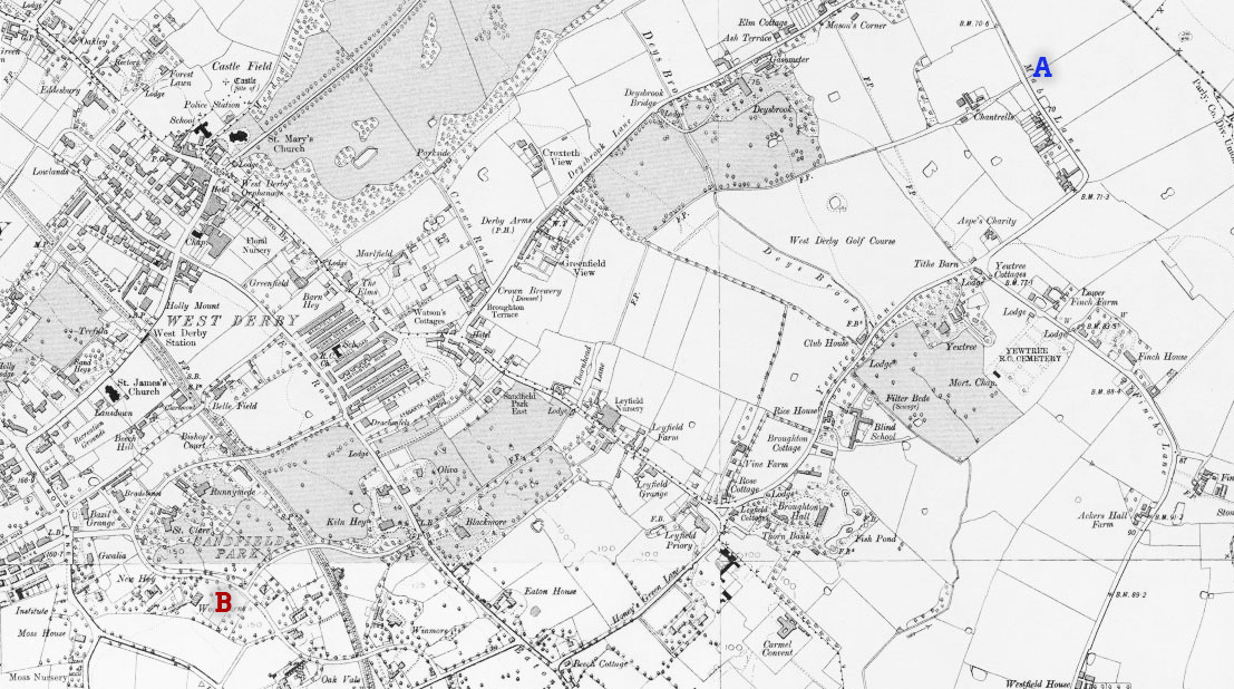
The video is of Blessig’s Style, a footpath running from Leyfield Road to Blackmoor Drive. Now blocked by a gate, it was originally part of a right of way. The path went all the way from Low Hill to Knowsley.
Blessig’s Style in West Derby
It survived as an accessible route well into the 20th century, and anyone who lived in the area up to 1965 will remember being able to use it to cut between the back gardens of the houses either side. Before the path was blocked by magistrates it ran unbroken from where the film was taken (Leyfield Road), straight across Blackmoor Drive and up to Eaton Road.
It’s interesting to see also that it lines up with Thornhead Lane (heading towards Sefton Rugby Club) at one end and Central Drive (part of Sandfield Park) at the other. The old maps shows, as you might be able to predict, that it can be traced to a great extent to the north east.
The route to the south west is not so clear on the Victorian maps. This is partly due to the disruption of the railway line cutting across it, as well as Liverpool’s own expansion.
Blessig’s Style in the 21st century
Of course, what us intrepid archaeological landscape explorers want to see are the clues on the ground! Well, you can still see evidence (beyond the gated route) amongst the 1930s housing of today.
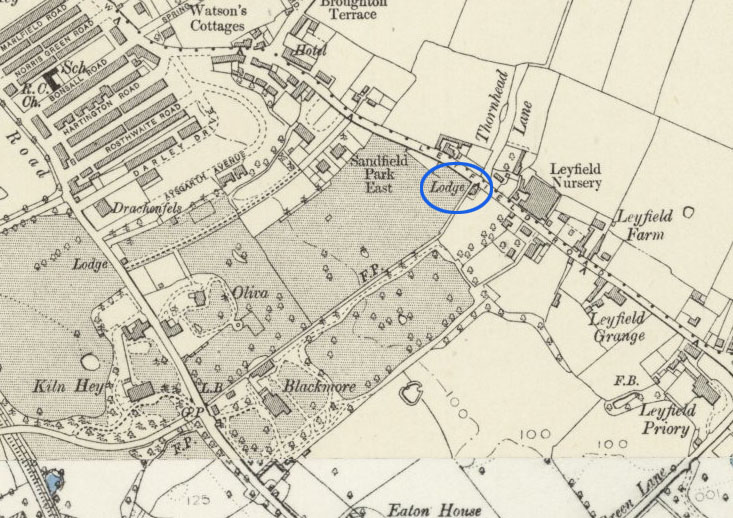
For a start, it’s no coincidence that a house much older than the surrounding ones occupies a plot on Leyfield Road. It’s immediately to the left of the path as you look south. This ‘Lodge’ is clearly marked on the map above (see also extract below). It guarded the entrance to the Blackmoor Estate from the north. It may even have been where deliveries and tradesmen would have entered the grounds of the house.
Moving to Blackmoor Drive and Eaton Road, larger gaps between houses mark the places where the footpath once carved its route through the fields. Indeed, one house on Blackmoor Drive may have a different design to its neighbours purely to adapt to the unusual plot. The wider gaps have now all been filled in, either with house extensions or walls. The gardens which back onto the former path have probably all been extended to cover the extra space.
Finally, on those wider gaps, you can also see an old sandstone wall which pre-dates the suburb itself. The video shows this wall on the left hand side (tragically half whitewashed). If you stand on Eaton Road today you can see the self same wall emerging from between the third and fourth houses.
Philip Jacob Blessig
Blessig’s Style takes its name from P.J. Blessig, a Russian-born merchant. Blessig came to Liverpool in 1845 at the tender age of 24, renting a house on Marine Crescent, Waterloo. He gradually increased his wealth in partnership with one Francis Caesar Braun (who bought Holly Lodge as a residence). By 1863 he was able to build his own house, Peterhof, in West Derby.
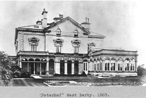
Peterhof was named after the Tsar’s summer residence on the Gulf of Finland(!). Rankin Heap, the house’s next resident, later renamed the house ‘Blackmoor’ (after the original name of the local area). Heap was a member of the Heap rice miller family of Heap’s Rice Mill fame.
Blackmoor was demolished in 1925 in order to build the houses which now cover the area (including my own childhood home!).
Well, I hope you’ve enjoyed this little jaunt through the secrets embedded in the landscape of West Derby. Local road names like Blackmoor, Eaton and Leyfield all have their origins in buildings around here. It’s good to be reminded of this by the likes of Blessig’s Style. Blessig was a Russian consul at one point in his career, but I wonder if he would have predicted that his name would live on for centuries in the minds of the local people!
Sources
A History of the Blessig Family, by Hugh Myddleton Heyder, accessed 28th October 2015
Ordnance Survey map of Lancashire CVI.NE, Revised: 1906, Published: 1909. National Library of Scotland. Accessed 28th October 2015.