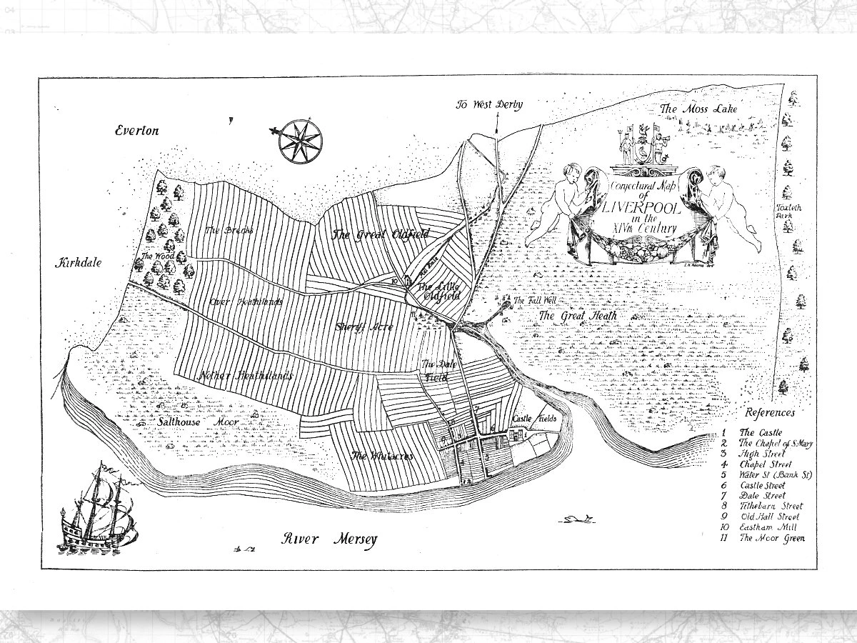
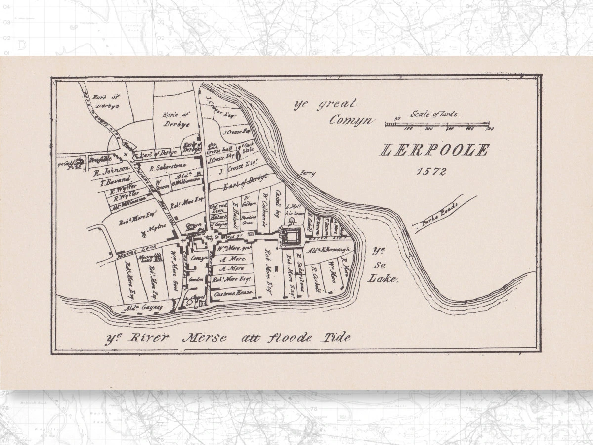
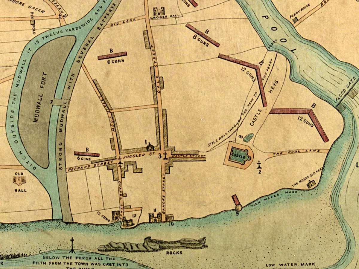
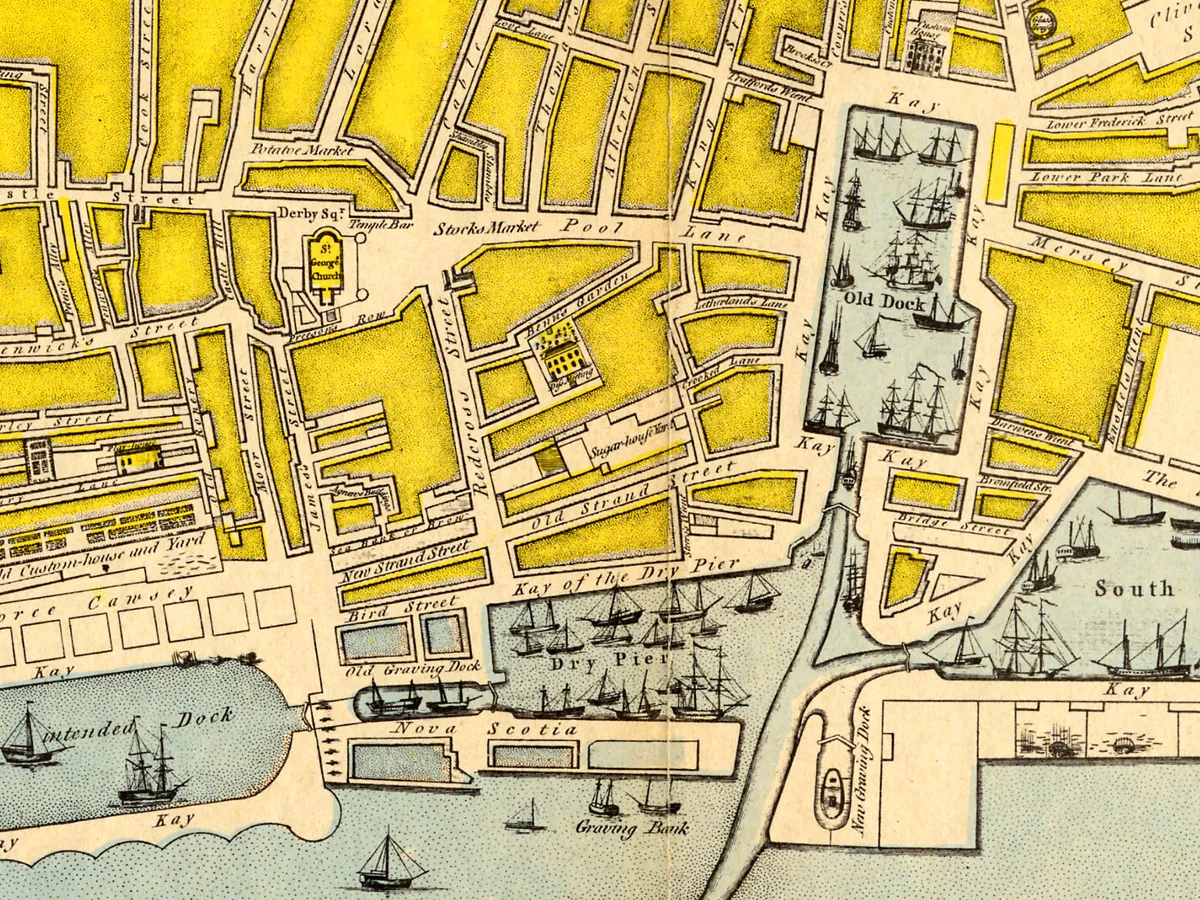
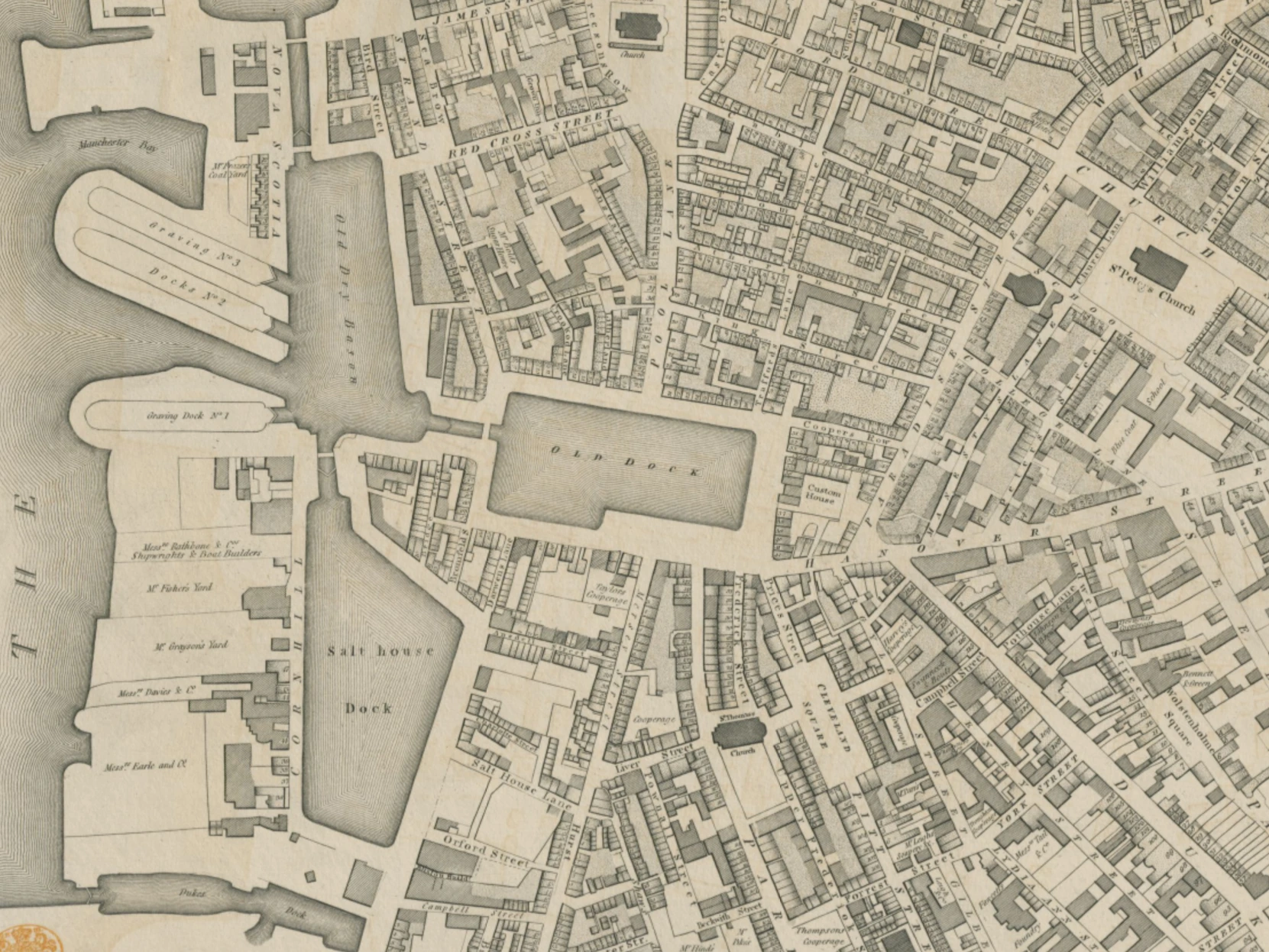
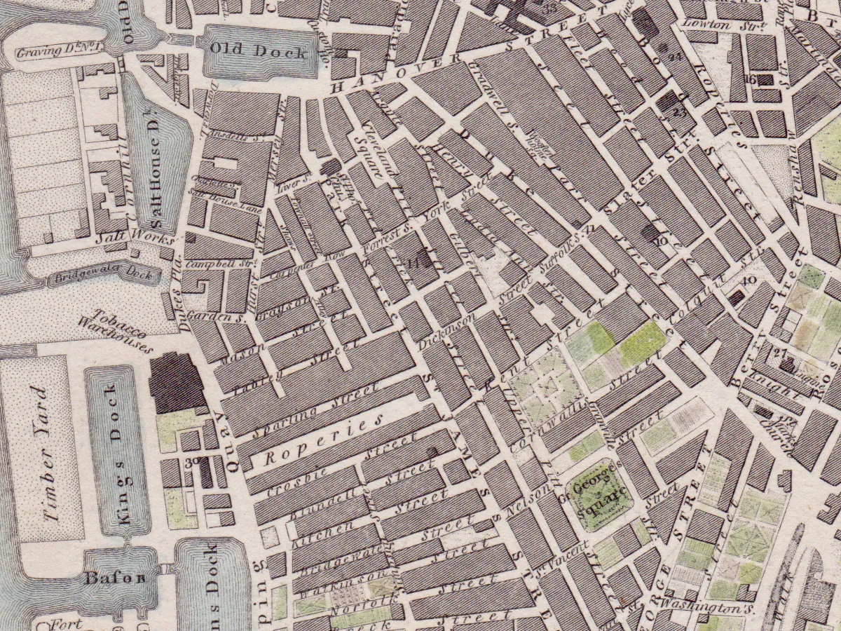
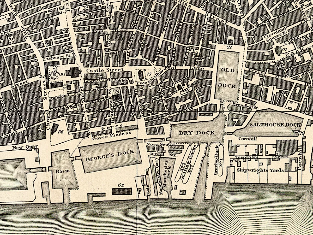
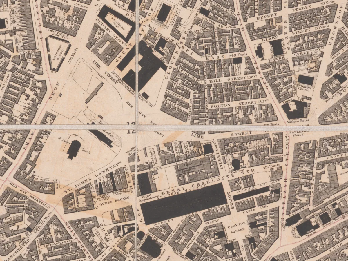
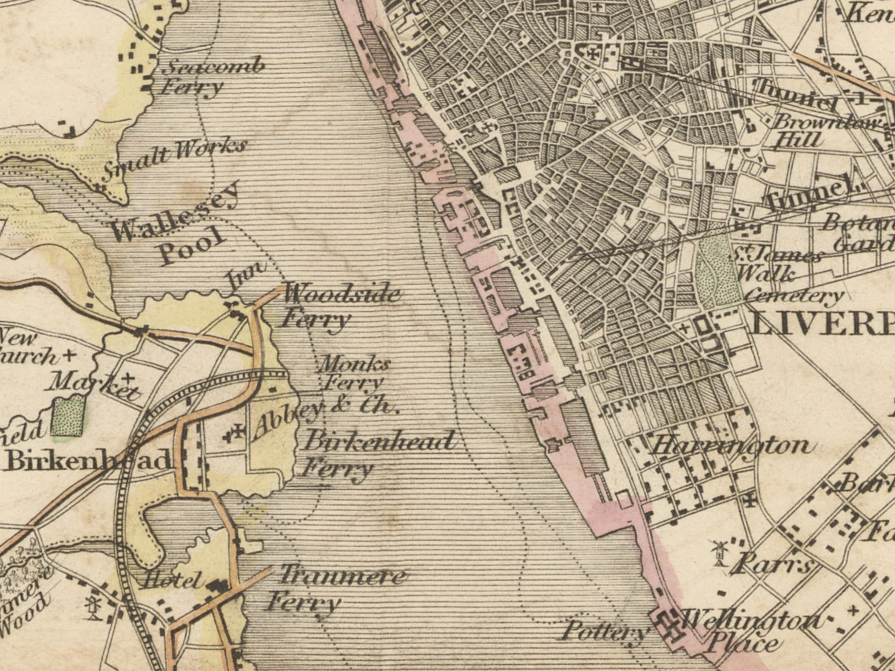
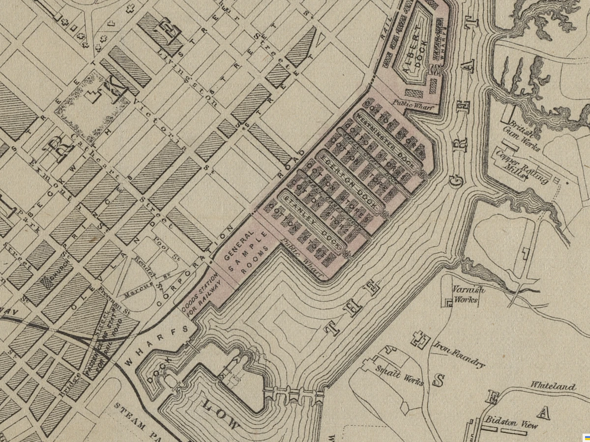
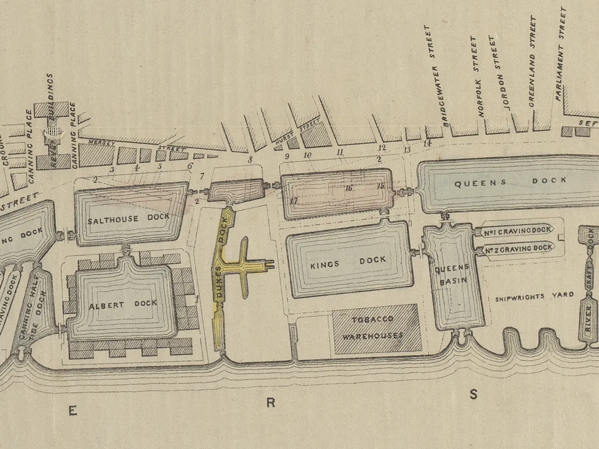
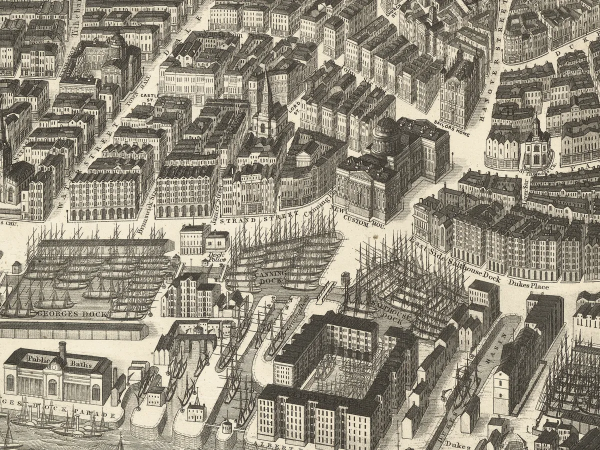
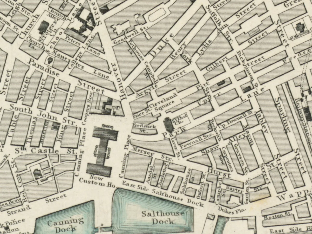
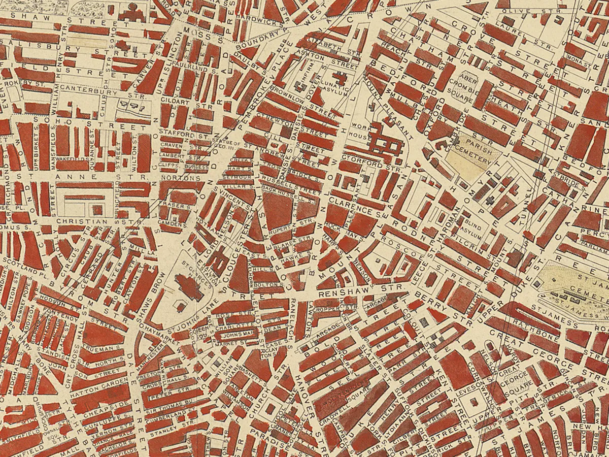
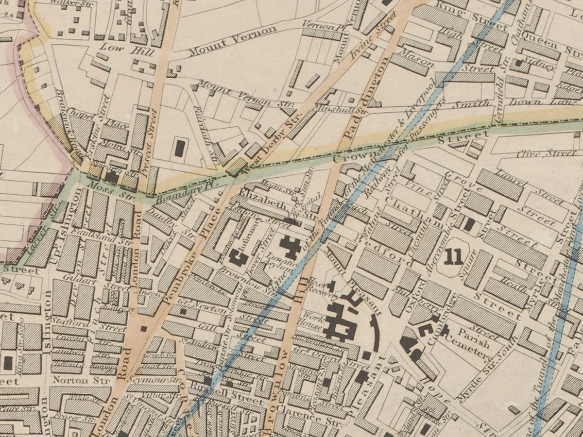
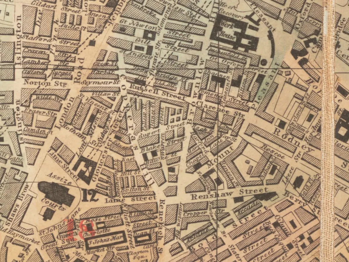
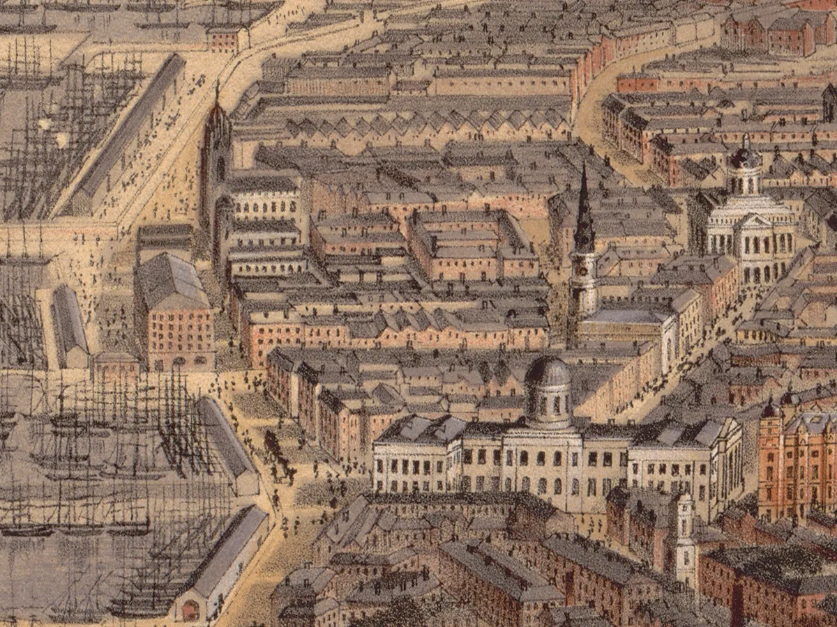
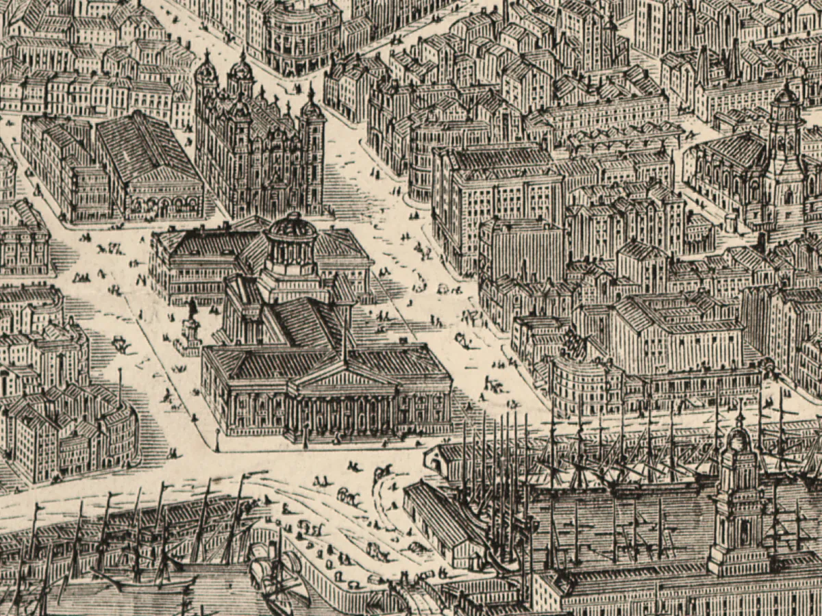
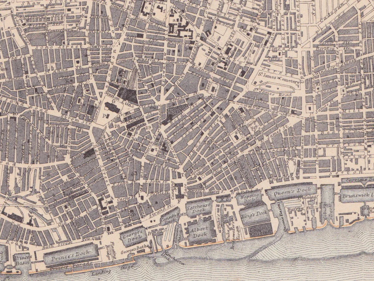
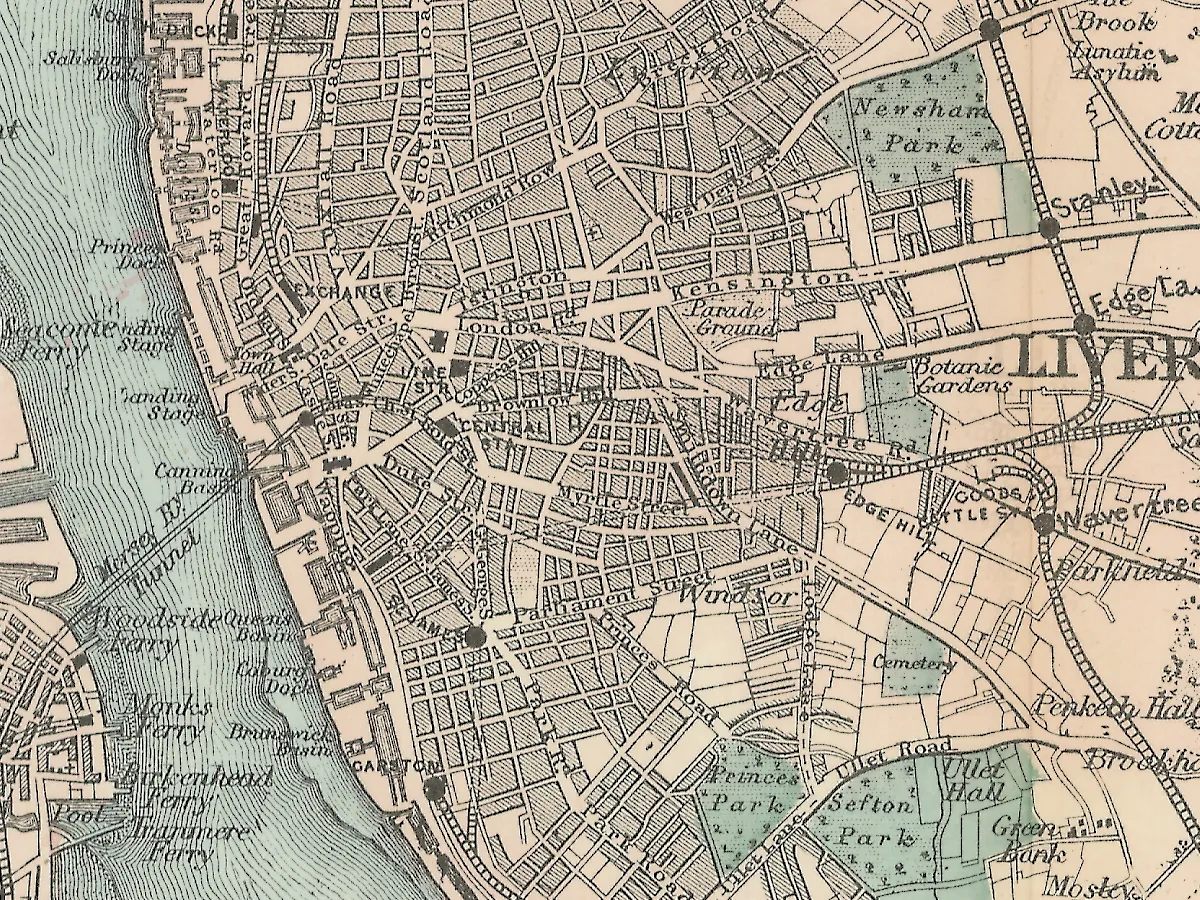
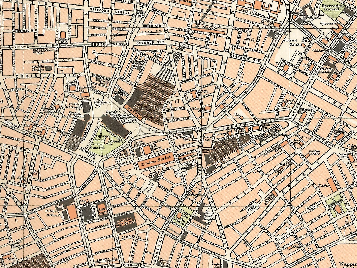
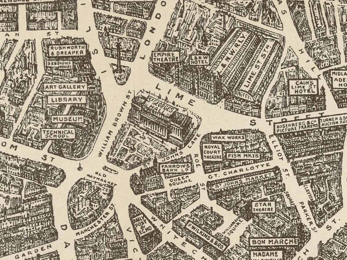
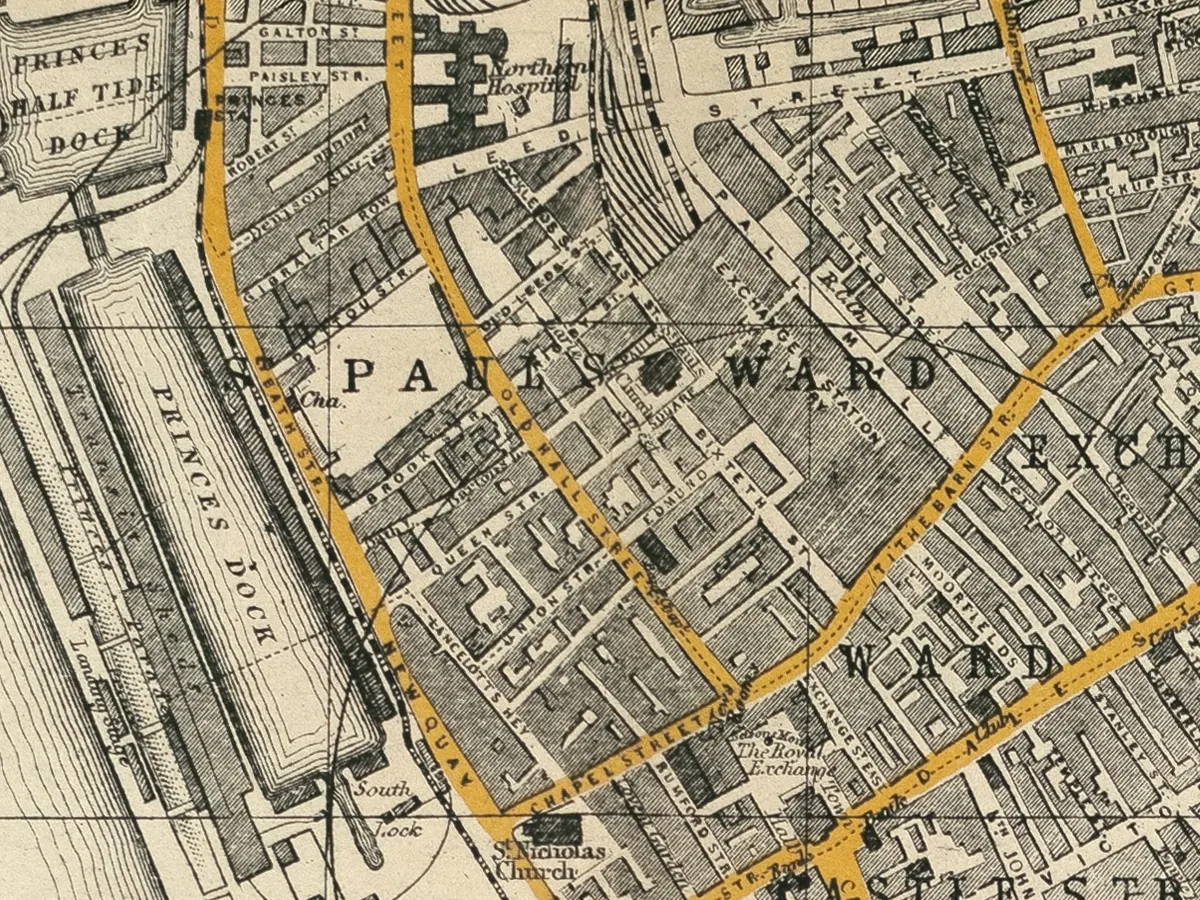
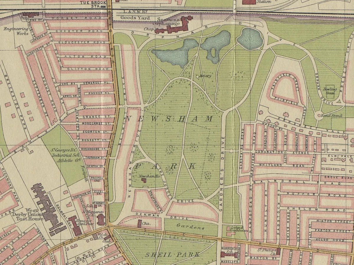
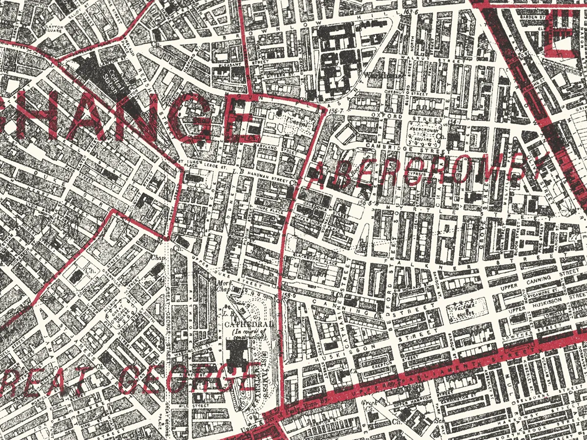
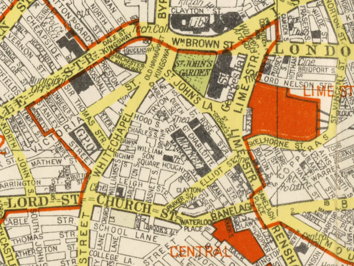
As a large city, Liverpool has seen a great many maps and plans made of it. Some of these maps show the wider area around the city. They may include areas as far afield as North Wales or Manchester, Lancaster or Chester.
Old maps are a great way to research the history of a place. They record changes in the landscape, like long-gone roads or new areas of houses for a growing population. Some show a familiar Liverpool, but look closer and you'll see all kinds of details that you may have missed. I recommend looking at some places you know well, such as the parks and streets you knew as a child. See if you can spot your old haunts!
Don't forget to check out the Interactive Maps, including the History Map which shows the sites that have been written about on this very website. It has a modern basemap with historic features laying out the things you can see in the landscape today.
There are other old maps of Liverpool dotted around the Internet, usually on national archives websites:
- A Plan of Liverpool, with the environs, Bibliothèque Nationale de France, accessed 16th October 2025.
- Map of Liverpool and its Environs (Southampton, 1874-1893), British History Online, accessed 16 October 2025. An excellent, very detailed map.
- 'Sheet 106', in Map of Lancashire (Southampton, 1846-1873), British History Online, accessed October 16, 2025. Not as detailed as the above map, and not as nicely scanned, but still of interest.
- Lancashire Old Maps, Cartophilia, accessed 16th October 2025. A huge list of Lancashire maps, though some of the links are now broken since they went through a redesign a few years back.
You can buy many of these old maps of Liverpool as high quality prints from the Liverpool History Book and Map shop. At the shop you can also buy notebooks, postcards and canvas style prints of some of the old maps.


Comments
Mapping the history of Liverpool
Old maps, interactive maps and the historic landscape of Merseyside.
Buy maps
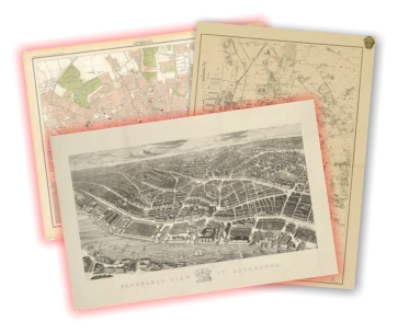
Many of the maps on this site can be bought as high quality prints, either as paper or ready-framed.
You can also buy notebooks, postcards, greetings cards and other map-printed items!
Go to the shop to find out more
The book
Liverpool: a landscape history is a book about Liverpool and Merseyside from the very earliest days to the 21st century.
You’ll learn about everything from the Calderstones to the Capital of Culture.
Signed copies are available direct from me, the author, in the shop.
#ads

A set of three matching Cassini maps from three different periods, designed to appeal to anyone who wants to discover the hidden history of their local landscape.
- Cassini Old Series Maps first published between 1805 and 1874
- Cassini Revised New Series Maps first published between 1896 and 1904
- Cassini Popular Edition Maps first published between 1919 and 1926
Leave a comment
Paul O'Donnell
05/01/2012 00:48:38
Reply to Paul O'Donnell
Martin Greaney
05/01/2012 12:09:31
Thanks for your comments. Yes, the ingenuity, not to mention the work rate, of the Victorians never ceases to amaze me. I think the fact that Edge Hill is around a station just spurred them on even more at the height of the Industrial Revolution, when Liverpool wanted to be the transport hub of Britain.
As to the discrepancy between the date when your road was built, this could either be because my publication date is slightly out, or that the mapmaker knew what was being built in that area, and/or that the record for when your road was built counts the date at which all buildings were complete, increasing the chances that the mapmaker could see the new road plans several years before, perhaps when they're being laid out.
I've seen some history books from the period which take great pleasure in detailing all the soon-to-be-built roads, and mapmakers were keen to be at the cutting edge, sometimes risking looking foolish if building projects didn't come to fruition.
Hope you enjoy the site!
Regards,
Martin
Reply to Martin Greaney
jim
12/26/2015 15:32:44
I have been looking at your site and trying to find out when the street ( Reading St Liverpool 5 ) was first built we left there in the late 1950,s as the street was being demolished many friends and neighbours were moved out to kirkby skelmersdale speke and some stayed local i have saw maps of the area 1885 but would like to know when it was built it was infamous for some trouble makers and the police so it was said walked down the street in twos i am now in my late 60,s but to us growing up there it was the best around
regards
jim byrne
Reply to jim
Martin Greaney
01/05/2016 14:10:12
The map you have of 1885 is one of the first maps which shows the road in existence. On the OS map of 1882 the area is still fields (brick fields) but a couple of roads nearby have been built, south of Lambeth Road, so it's easy to say that the area was being built up at that time. So Reading Street was built between 1882 and 1885.
Martin
Reply to Martin Greaney
joseph Farley
12/31/2016 11:51:01
Paul and Annie Simpson where my grand ma and grandad.
Reply to joseph Farley
Robert
06/02/2017 13:38:44
Reply to Robert
Paul O'Donnell
05/01/2012 00:58:46
Reply to Paul O'Donnell
wilson
07/10/2015 19:14:36
please contact 07407358633
this is along shot as I see the old place is gone
Reply to wilson
Kevin Davies
02/17/2021 12:23:24
Many thanks
Kevin.
Reply to Kevin Davies
Martin Greaney
02/19/2021 12:20:34
I haven’t seen any photos of the street itself, but there’s a great map that shows that your Mum was right in saying that one side of the north half had the walls of the Bedford Street South houses on it. If I come across any photos I’ll post them here.
The map: https://maps.nls.uk/geo/explore/side-by-side/#zoom=17.408816872525154&lat=53.40096&lon=-2.96541&layers=168&right=ESRIWorld
Regards,
Martin
Reply to Martin Greaney
Kevin Davies
02/24/2021 10:29:25
It all just fascinates me over a span of ten/ fifteen years how Myrtle street could change from a thriving high street, to a scene of pure devastation.
I do understand about failed schemes but to abandon such an area of so many fine elegant Georgian terraces and you come to realise the are less than a quarter of what was still there in the early fifties is truly heartbreaking.
One of the worst examples of this is the vandalism shown to Bedford street south/north . The beautiful Georgian terrace chopped in half by that hideous Rathbone building.
How much we had and how much we lost!!!!!!!!!!!!!!!!!!
Reply to Kevin Davies
Tracy Reppion
04/27/2021 19:30:19
Thanks in advance for any information you can give me.
Tracy
Reply to Tracy Reppion
Martin Greaney
05/05/2021 22:06:45
Looking up that address on the current Google map brings up the large junction with an Aldi, and looking up that site on the old maps shows the West Derby Union Workhouse. I don’t know if the addresses are the same, but considering your ancestor’s adoption then perhaps he was born to someone in the workhouse.
There’s loads of information online, one source of which is Historic England: https://historicengland.org.uk/images-books/photos/volume/BF102391
Make sure not to confuse this workhouse with the one which was once on the site of the Catholic Cathedral. :)
Regards,
Martin
Reply to Martin Greaney
David Hojman
12/09/2023 18:33:49
Many thanks for that side-by-side map. As you say, it is really great. Incredibly helpful. Would you happen to know which of those houses which sadly disappeared (I do not know if a result of the blitz or the University planners) was number 74? That is, 74 Bedford Street. That is the address where, according to Wikipedia, the actress Mary Lawson and her husband were staying at the beginning of May 1941, when they were both killed in the bombing. I think it is very sad that there is not even a small sign or notice remembering her.
Many thanks
David
Reply to David Hojman
Lynn
04/02/2021 17:01:06
Just found out my nan and granddad , James and May Henry lived in number 23 Heath street, with my mum and her siblings, Bessie, James, Peggy, Gladys, and Agnes . I wonder if your mum remembers them. They later moved to 154 Chatham street so not to far.
Reply to Lynn
Gaye Schultz
05/27/2012 15:21:21
I am researching my family history. I was wondering if you may be able to help me. My Great Grandparents, Samuel and Mary Anne Dickinson, lived at 109 Medlock Street, Kirkdale. They lived there for a number of years before moving to Wallasey.
can you tell me anything about Medlock Street?
Any information that you may be able to provide will be greatly appreciated.
Kind Regards, Gaye
Reply to Gaye Schultz
Martin Greaney
05/28/2012 11:19:03
Medlock Street is just a tiny stump of road now, leading north west from Westminster Road, but it once ran right through to Rumsey Street before the park was created.
There are two really good pictures looking down the road on the Kirkdale Online website. You can see in the second picture the curved building which still sits on the corner with Westminster Road. The Kirkdale Gaol was the biggest landmark in the area, sitting on land between Garnet Avenue and North Dingle.
The houses on Medlock were slightly bigger than many of the tiny terraces which characterised Kirkdale and Everton in the 19th and early 20th centuries, having bay windows for example. It's quite a shame these were demolished, as they were not at all slum housing, but large areas were given over to the wrecking ball in this part of town without much selectivity on the part of the council.
Do you know what kind of jobs your great grandparents did? These houses were often inhabited by those who worked in city centre offices, or the docks, but were slightly higher than the bottom rung of casual labourers - such as clerks, messengers and the like.
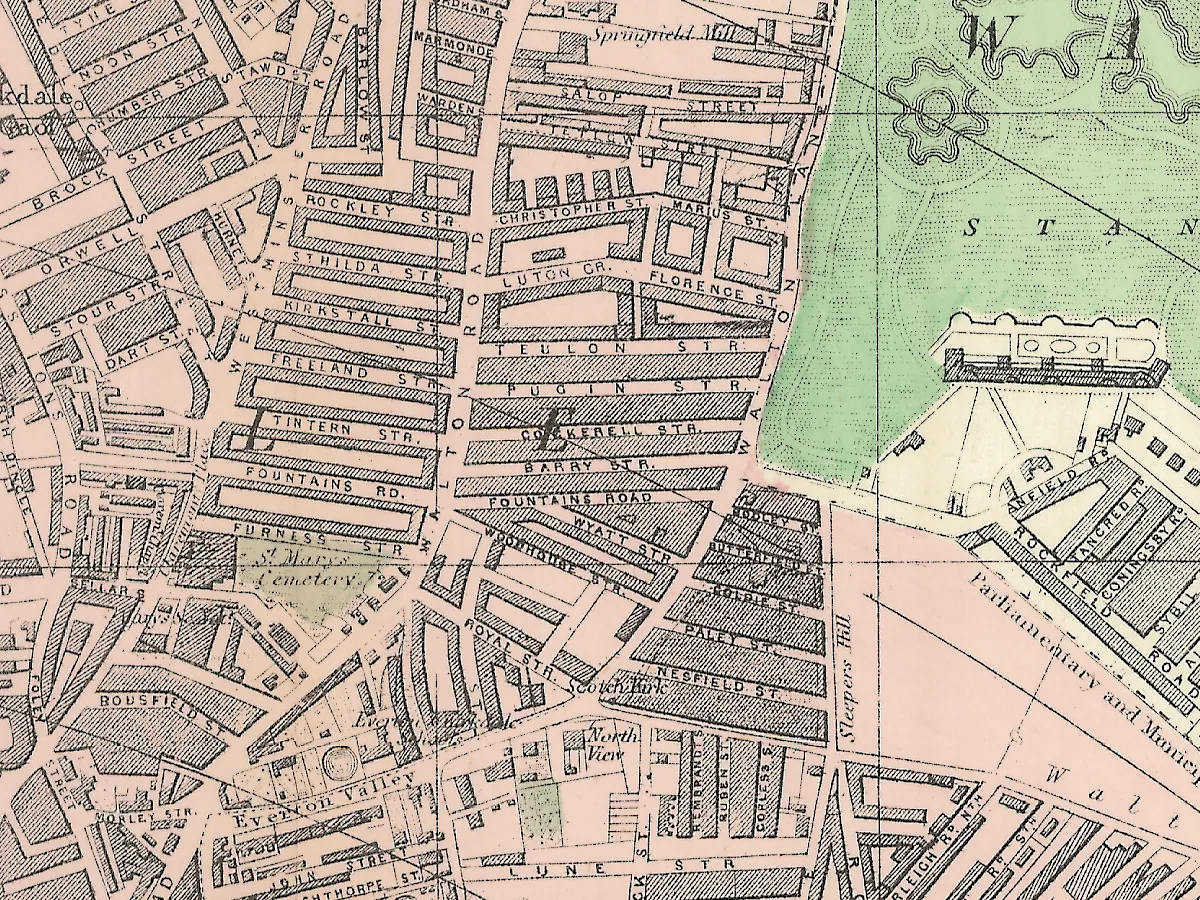
Here's an old map of Kirkdale showing Medlock Street and the Gaol.
Reply to Martin Greaney
Gaye Schultz
06/01/2012 01:56:26
Great to hear from you, and I really appreciate the time that you have taken.
Kind regards, Gaye
Reply to Gaye Schultz
Martin Greaney
06/01/2012 10:50:18
Regards,
Martin
Reply to Martin Greaney
Jennifer
06/29/2012 20:42:48
I am in the process of researching my family history and have discovered that my maternal great grandparents lived for several generations in Liverpool. Based on the 1881 and 1891 census they lived on Jackson Street and Vaughan Street. I can't seem to find either on the maps. Can you point me in the right direction?
Many thanks!
Jennifer
Reply to Jennifer
Martin Greaney
07/03/2012 17:35:16
I've not been able to find the exact place, but the censuses suggest that Vaughan Street is in south west Toxteth. I'll have a look though my maps of the area, but even if I can't find the street at least maybe you have a general idea of the place they were in!
I'll post here if I find anything.
Regards,
Martin
Reply to Martin Greaney
Anthon A
07/05/2013 22:17:11
Reply to Anthon A
David Lindley
09/11/2015 21:04:47
Reply to David Lindley
Dave Wood
01/24/2017 12:57:45
Vaughan St was between Grafton St and Beaufort St and Jackson St was between Upper Warwick St and Upper Hill St. You can view both streets in these cropped images of a 1906 map and I've included the link to the full size map in the "Website" box. Great site Martin.
http://liverpoolpictorial.co.uk/jackson_street.gif
http://liverpoolpictorial.co.uk/jackson_street.gif
Reply to Dave Wood
Dave Wood
01/24/2017 13:00:34
Reply to Dave Wood
Martin
02/05/2017 17:20:08
Martin
Reply to Martin
Carol
07/24/2012 18:38:25
Do you know the name of the pub which used to be on the corner of Netherfield rd and Kirkdale road in the war times?This would solve a longstanding search for my uncle who`s asked everybody already.
Thanks
Carol.
Reply to Carol
Martin Greaney
07/26/2012 21:06:53
I did a bit of research and replied to your previous comment here: http://historic-liverpool.co.uk/kirkdale/#comment-11917. Hope one of the two pubs I mentioned is the one you're looking for, but if not it might start you in the right direction!
Martin
Reply to Martin Greaney
reginal pearson rostock
10/23/2012 19:50:22
Reply to reginal pearson rostock
Martin Greaney
11/14/2012 20:10:27
Martin
Reply to Martin Greaney
chris moore
12/28/2012 14:44:02
Reply to chris moore
Martin Greaney
01/26/2013 20:03:02
Pleasant Street was very much exactly that on the first Ordnance Survey map (1850). Although there was a large timber yard at the western end (on the northern side) the rest of the street was residential. There were two chapels and a school, but the rest were houses with large gardens. The largest houses were actually on Clarence Street, with their side (and back garden) running along Pleasant Street. Some of the gardens are shown in great detail on the map, with paths and flower beds in dotted lines.
The houses that actually fronted onto Pleasant Street were smaller, with yards behind. Your own knowledge of your ancestors' lives may shed more light on what the houses actually looked like.
Cubbin Street is no longer with us, but the name lives on in Cubbin Crescent, which sits on the same site in Kirkdale. The street wasn't built by the time of the first few OS maps, and only appears in 1890. The houses on this street were small terraced houses, slightly smaller than those on Pleasant Street. There are some pictures of Cubbin Street rooms on Liverpool Pictorial. Those photos were taken in 1957, and show the rooms in a shocking state. However, a lot can change in 40 years, so I wouldn't go assuming those are the conditions your ancestors lived in. However, you do get a very rough impression of the room size.
Reply to Martin Greaney
chris moore
10/12/2013 13:31:11
Reply to chris moore
mike woods
04/06/2013 01:25:11
Reply to mike woods
chris moore
06/11/2013 19:33:58
My dads family where called Moore lived in Cubbin Streeet there was a gang of them ha ha my dad was the youngest they must of known your ancestors ,as they liuved next door to each other .
Reply to chris moore
Gloria woodman
02/15/2013 23:55:53
I'm researching my family who lived in the Toxteth area of Liverpool. I am told that my Mother and I lived in a pub called the Alhambra in that area during the war. The landlady, Bessie Hatfield, was my Aunt. I actually remember going to this pub in about 1946/47. Although I have been looking for it via the internet for several years I can now find no trace of it at all. Can you help please?
Many thanks.
Gloria
Reply to Gloria woodman
Martin Greaney
02/20/2013 19:27:30
I've found information about the Royal Alhambra pub on the corner of Esk Street and Derby Road, which is in Kirkdale rather than Toxteth (though similarly near the river). Unfortunately it's no longer there, but was on the vacant plot here at the end of Esk Street. The old 1:2500 maps show it marked 'PH' (public house).
Regards,
Martin
Reply to Martin Greaney
cathy iles
05/18/2015 21:28:08
Reply to cathy iles
Rob S.
03/28/2021 21:22:34
I saw your post. Would it be possible to send me via email the scan of the building that had been the Alhambra pub on Derby Road? I know a lady who lived there in the late 1930s and she would be thrilled to see it. Thanks
Reply to Rob S.
Kevin Davies
02/24/2021 10:32:24
It all just fascinates me over a span of ten/ fifteen years how Myrtle street could change from a thriving high street, to a scene of pure devastation.
I do understand about failed schemes but to abandon such an area of so many fine elegant Georgian terraces and you come to realise the are less than a quarter of what was still there in the early fifties is truly heartbreaking.
One of the worst examples of this is the vandalism shown to Bedford street south/north . The beautiful Georgian terrace chopped in half by that hideous Rathbone building.
How much we had and how much we lost!!!!!!!!!!!!!!!!!!
Reply to Kevin Davies
Patricia Clerkin
02/19/2013 20:11:15
Reply to Patricia Clerkin
Martin Greaney
02/21/2013 16:04:04
The 1891 Ordnance Survey map shows a Victoria Hotel at the top of Compton Road, at the junction with Whitefield Road. It could have changed names before the 1920s, especially if your grandfather took it over from someone else, but that's the most certain evidence about the pub I can find. Hope this helps!
Ad you're right - the amount of deprivation in this part of Liverpool was shocking. Some of the conditions right into the 1960s and beyond still surprise me. Makes me appreciative of how a lot of us live today!
Regards,
Martin
Reply to Martin Greaney
john
03/27/2013 20:55:19
Please
Thank you
Reply to john
Martin Greaney
05/09/2013 17:01:57
I've not been able to find any photos yet, but if you know any more details about where the timber yard was I might be able to have another search.
Martin
Reply to Martin Greaney
James
03/18/2021 00:59:55
Reply to James
Joseph Davison
06/01/2013 10:49:10
Reply to Joseph Davison
Lindsay
06/22/2013 14:28:48
I wonder if you could help-I'm trying to find old maps of the Halewood area.
Do you know where I could obtain a copy of Lancashire Sheet 114 1890-1 and also 1849 printing. They are on display at the Rangers Hut at Pickerings Pasture but a request for a copy fell on deaf ears!
I have some old tythe maps of the area but they are very poor-copied from worn out maps at Central Library.Do you know of any maps that might be better? I was told that one can go to the Lancashire Record Office but that you have to actually photograph them.
Any help would be appreciated!
Lindsay.
June 22, 2013
Lindsay.
Reply to Lindsay
Martin Greaney
06/25/2013 20:20:23
A great source for old maps is (appropriately) Old-Maps.co.uk. You can search for Halewood on their home page, and it then gives a selection of old editions on the right. You can see a fair bit on the site, but to get big high quality copies it costs about £16. They have the 1849 edition at 1:10,560 and 1893 at 1:2500 (very high detail, but small areas covered per sheet).
When you ask whether I know of any maps which would be 'better' than the tithe maps, what is it you'd like to find out? Or are you just after some better copies of the same thing? Lancashire is probably the closest place, as the main other one will be the National Archives in London!
Hope this helps a bit, but do let me know more detail if you have some specific queries and I'll see what I can do.
Regards,
Martin
Reply to Martin Greaney
Mike Keyton
07/31/2013 22:25:38
I used to attend Liverpool City Institute of Further Education 1967. It may have been an annexe but the GCE courses were taught in a pale blue building on the corner of Duke St facing the Anglican Cathedral. This building has now been demolished along with the road and replaced by the Cathedral Gate development. Have you any maps that show the name of this now extinct road?
With no photos and no as yet found record of this building that literally changed my life, I feel a part of me has been amputated. I can feel the ghost limb twitching.
Cheers,
Mike.
Reply to Mike Keyton
HILDA BRESLIN
08/04/2013 15:32:35
Reply to HILDA BRESLIN
Thomas shone
12/12/2013 22:02:26
I was born in 9 leith terrace in 1951 and lived there until the compulsory purchase slum clearance in I think 1969 when they were demolished. They were a row of Seven two up two down terraced houses which do not appear to show up on any early maps I have seen it was situated off forth st situated between Clyde st an Esk st. These last two streets named led on. to a main rd called Dearby rd which was the next main rd up from the Dock Road at Canada Dock
Hello Hilda
I was born in 1951 in Leith terrace and lived there until the compulsory purchase slum clearance in I think 1969 . It was a row of seven , -two up -two down terraced houses with a dead end.. It does not appear to show up on any early maps I have seen.It was off forth st and situated between Clyde st and Esk st both of the last named streets led onto a main rd called Dearby rd which was the next main rd up by about 200 yards parallel to the dock rd at Canada Dock.
hope this helps Tom
Reply to Thomas shone
Niki Timpson
05/20/2021 06:17:39
My Great Grandad was John Weston, married to Elizabeth, and they had 7 children; 6 boys and 1 girl (Ethel)
Don’t suppose you remember them? Would have lived opposite you I think?
Niki
Reply to Niki Timpson
Margaret Cooper
08/16/2013 22:22:10
Can any one help please?
My Gt, Gt, Gt. Grandfather was Living in Gascoigne St (i3 onNorth map) in 1852 and was married from this street. He was married in "St Davids Church" . I have found Gascoigne St on this wonderful map but unable to find a St Davids church in the area! does any one know if their was a Church of that name in the area of Gascoigne St?
Margaret
Reply to Margaret Cooper
Ann Khan
02/09/2014 00:33:50
St David's Church was at the bottom of Brownlow Hill (South Map). My Great Great grandparents were married there. It was known as the Welsh Church I believe. It is the last entry on this web page. http://www.lan-opc.org.uk/Liverpool/Liverpool-Central/home.html
Reply to Ann Khan
Mike Keyton
09/14/2013 16:36:36
I used to attend Liverpool City Institute of Further Education 1967. It may have been an annexe but the GCE courses were taught in a pale blue building on the corner of Duke St facing the Anglican Cathedral. This building has now been demolished along with the road and replaced by the Cathedral Gate development. Have you any maps that show the name of this now extinct road?
With no photos and no as yet found record of this building that literally changed my life, I feel a part of me has been amputated. I can feel the ghost limb twitching.
Cheers,
Mike.
July 31, 2013
Reply
Reply to Mike Keyton
Martin Greaney
10/08/2013 21:27:12
Could you be thinking of Rathbone Street (and Back Rathbone Street)? They were on the site of the current Cathedral Gate, east of Great George Street. I've found a map of the area from the period you're talking about, but can't see the Institute on it. Perhaps you'll be able to spot it! http://www.old-maps.co.uk/maptiles/m100955_335319_389554.png
Reply to Martin Greaney
Mike Keyton
10/28/2013 21:08:48
And thank you. My building was on the corner of Upper Duke St. and St James street (which has now been built over by the cathedral gate development. I found the map really useful because now I have a street name with which to approach Liverpool library/archives - unless I can find something online.
Thanks again
Mike.
Reply to Mike Keyton
pauline
09/24/2013 20:36:24
Reply to pauline
Martin Greaney
10/08/2013 21:46:15
Here's a map of the Strawberry Fields estate. It's not a detailed look at the house, but hopefully it's what you're after.
Regards,
Martin
Reply to Martin Greaney
nancy smith
10/28/2013 00:26:24
thanks,
nancy
Reply to nancy smith
Martin Greaney
10/31/2013 21:54:17
While it's certainly possible that a residence was in the same building as a small business like a drapers (just like today a grocer's or newsagent's might have a flat above or a house behind and above) by the look of the maps of the streets in the area the houses look like standard terraces. It might be that your ancestor worked at home, but there was likely not a shop at that address. If he was not the business owner, then perhaps his place of work address was not associated with his name.
Regards,
Martin
Reply to Martin Greaney
Paul Lynch
11/03/2013 14:07:05
I have seen photos near these locations but never the actual buildings.
Regards
Paul
Reply to Paul Lynch
neil spruce
01/05/2014 21:51:09
Reply to neil spruce
Martin Greaney
01/08/2014 19:32:23
The website Old-Maps.co.uk is your best bet for these maps. They have one from 1955 which marks the Customs House as 'Ruin'. It also names the streets around that area, although they're a little hard to see without buying the map. As far as I know, the landscaping of Chevasse Park, which was removed in the last few years to be replaced with Liverpool One, was that landscaping which was put down in place of the Customs House, though if anyone else knows better I'd be glad to hear from them! Coronation Park was further to the East, at the top of Lord Street.
Regards,
Martin
Reply to Martin Greaney
James Edwards
02/07/2014 20:49:01
Kind Regards
James
Reply to James Edwards
Jessica Nutt
02/21/2014 18:24:29
Thanks
Reply to Jessica Nutt
Derek
06/15/2017 15:19:35
one of my ancestors was born in 5 Baptist street , and i am too desperate for information but cannot find it .
did you find anything at all .
Reply to Derek
Paddy Mahon
04/01/2014 09:20:13
Thank you, Paddy Mahon Sydney Australia
Reply to Paddy Mahon
Lynne Lay
09/28/2014 13:35:47
Reply to Lynne Lay
Lynne Lay
09/29/2014 08:14:12
http://www.bootlehistory.co.uk/forum/viewtopic.php?f=3&t=30197&p=384634#p384634
It was off Balliol Road just by its junction with Breeze Hill just opposite where Balliol Secondary school used to be. Hope the link works and that you find this answer.
regards Lynne
Reply to Lynne Lay
Pat Collins
08/29/2014 16:32:42
Reply to Pat Collins
Paul Robinson
09/25/2014 15:24:56
I am trying to find an image of Cadmus street, Everton. I have tried the Liverpool Records Office but without any success. Any thoughts/help would be most appreciated.
Reply to Paul Robinson
Martin Greaney
09/29/2014 11:31:30
Glad you like the site! Have you got access to the original handwritten census return? I've found that when having trouble locating streets from census records the original is poorly written or transcribed, or the census writer misheard someone else naming the street. Try looking at this list of Liverpool streets beginning with C, and comparing it to what is written on the form, to see if the error is of this type.
Regards,
Martin
Reply to Martin Greaney
Paul Robinson
09/30/2014 13:08:05
Thank you for your speedy reply and helpful comments/suggestions.
I do not have access to the original census return but have seen the name Cadmus Street (adjacent to Dido Street) in an old (~1900) map of the area.
I looked at the Liverpool Streets site but without success.
Many thanks again and may the site go from strength to strength.
Paul
Reply to Paul Robinson
Lynne Lay
09/28/2014 13:39:04
Reply to Lynne Lay
Lynne Lay
09/29/2014 08:15:34
Reply to Lynne Lay
Kath O'Brien Briggs
10/08/2014 17:11:34
Reply to Kath O'Brien Briggs
Peter Murphy
11/01/2014 22:30:43
I've worked at Buckels garden centre in Fazakerley for 20 years it's on the corner of Field lane and Copplehouse lane. We know it's been there a while but we are curious what was there before it or when then Buckels family moved there. Its not owned by the Buckels family now so any information would be appreciated. My boss says they got land off the Molyneux family. Great website and maps by the way.
Reply to Peter Murphy
Martin Greaney
11/05/2014 21:40:31
Glad you like the site! The site of the garden centre seems to have had nothing on it until a number of glasshouses were erected in about 1900, behind the house (belonging to the Buckles?) which stands on the corner of the two roads. So it looks like Buckles Nurseries has a long pedigree! It's definitely possible that they bought land for the house off the Molyneux family, who were the major landowners in the Sefton area for a long time.
Here's another map for you, showing the road junction in 1927, as well as the house and a couple of the glasshouses (with the cross-hatching):
Reply to Martin Greaney
paul simpson
08/05/2017 22:17:10
Love this site, it is addictive.
Thank you.
Reply to paul simpson
Matt
11/30/2022 19:02:26
I'm Chris' son and came across this post and thought since it is a history site and all I'd just have a whinge that now that Buckels Nursery and Garden Centre has been replaced by housing it is a bit rude that the road running through it is Buckles Road, when the name is Buckels! I shall return one day to avenge this lol.
Reply to Matt
Kay2
11/12/2014 22:35:26
I recently read your wonderful book about Liverpool's landscape history. Absolutely fascinating!
Can you help me locate an old street? By the way, your links to old maps don't appear to work - I'm getting the dreaded Error 404 messages. I'm looking for Bennett Street. In my Edwardian A-Z, it's in the index but despite searching I can't find it on the accompanying map.
Any ideas?
Karen in Ontario
Reply to Kay2
Martin Greaney
11/13/2014 12:14:59
Thanks so much! So glad you liked it. And thanks for pointing out the 404 error - should be fixed now! Teething problems from an exciting new angle for Historic Liverpool!
Bennett Street, if I've got the right one, is in Garston, just off St. Mary's Road. You can see it on the 1907 map below, and it is still there, visible on Google Maps. Let me know if this is the right one, and if you can spot it in your Edwardian A-Z.
Reply to Martin Greaney
Phyl ( walton )
05/23/2015 20:18:34
Reply to Phyl ( walton )
Martin Greaney
05/27/2015 08:59:53
Looking at the old maps shows that there was a dairy yard in the area. I've put a map here so hopefully you can see whether this is the area where the lower window was. If it's one of those windows which is half buried then that would match with an industrial use, where perhaps cellars were used (e.g. for keeping dairy products cool).
The map is from 1953, at 1:1250 scale.
Reply to Martin Greaney
Phil D
06/24/2015 16:03:12
Can you please tell me where i could get a copy of the 1953 map showing Kirkdale / Walton. Is it available from the Liverpool Central Library ?
Regards
Phil D
Reply to Phil D
Martin Greaney
06/24/2015 16:21:42
Martin
Reply to Martin Greaney
David Wardle
09/20/2015 21:29:18
Reply to David Wardle
Jimdduggan@icloud.com
11/13/2021 21:51:02
Reply to Jimdduggan@icloud.com
Jo Jenkins
10/16/2015 14:58:10
I wonder if you have any info on the origins of Shaw's alley L1, my nan's great grandfather was brought up there around 1900's
Reply to Jo Jenkins
Martin Greaney
10/19/2015 12:57:41
Looking at the old maps of the time, Shaws Alley (then called Shaw Alley) looks mostly to be large buildings, probably warehouses. There are some smaller buildings at the town end of the street, so presumably that's where your great grandfather was brought up. It may be that the name Shaw comes from Samuel Shaw, an industrial potter who had his works on the aptly name Shaw's Brow, which is now William Brown Street (where the Museum and Library are). Shaw (whether Samuel or another Shaw) may have owned the land that the street was built on, or had his home, office or warehouse here.
Best wishes,
Martin
Reply to Martin Greaney
Jacqueline Lewis
02/10/2016 22:02:46
Can you tell me where exactly Atterbury Terrace was/ is off Grafton Street, Toxteth ? I try to visit where my ancestors lived but can't find this one.
Kind regards.
Reply to Jacqueline Lewis
Tony Heron
02/11/2016 17:24:21
Reply to Tony Heron
Martin
02/17/2016 10:40:14
Courts were usually included on maps, though their small size meant that many weren't named except on the most detailed maps, and perhaps wouldn't be included in indexes. The less detailed maps might not have had them on at all, or marked them in a way which is not recognisable as a court.
Martin
Reply to Martin
Tony Heron
02/14/2016 15:19:30
Reply to Tony Heron
Jane
08/27/2016 10:22:01
Has anyone got any information about the Graves family? We think they lived at 122 St. James Street just before the first world war. Any photos/maps of the area would be brilliant
Reply to Jane
Keith Bowen
09/10/2016 15:55:38
Reply to Keith Bowen
Martin
10/17/2016 20:56:21
I wonder whether this could be a bridge over the Stanley Dock branch of the Leeds Liverpool Canal? There would have been people living in that area at the time, so if there's any evidence that your ancestor was born in north central Liverpool then that might be the case.
Martin
Reply to Martin
Caroline
10/26/2016 10:18:53
Would you know where Oldham Court, Back Renshaw a Street was please? My great grandmother lived there when she was a child. Thank you.
Reply to Caroline
Martin
11/03/2016 22:16:21
If you look at this map of Liverpool in 1898 you'll see Oldham Street in the middle. The road which is un-named but goes across it is Back Renshaw Street. There are several courts in that arrangement of streets, and Oldham Court would have been one of them.
Martin
Reply to Martin
Caroline Fildes
08/28/2020 12:31:51
Reply to Caroline Fildes
cstafford
10/26/2016 17:12:30
As a total Novice could anybody point me in the right direction? I'm looking at my mother's Irish ancestry and as par of this I'm trying to find her birthplace which was Paton Street Kirkdale. The 1901 A-Z does not list Paton Street...any help would be gratefully received Thank you
Reply to cstafford
Martin
11/03/2016 22:20:10
I've not been able to find Paton Street. Could it be Parton Street? There's one in Kensington, which isn't really what I think of as Kirkdale, but the houses are the right age, and it might have fallen in the Kirkdale boundary at one point.
Martin
Reply to Martin
Pauline Evans
01/16/2017 19:26:57
Reply to Pauline Evans
Martin
01/09/2017 18:41:27
I've been sent some great aerial photos of Paton Street by Phil D. I'm including a couple here, while everything's on a separate page at Paton Street, Kirkdale, in aerial photos and maps.
Best wishes,
Martin
Reply to Martin
sandra sugden
11/23/2016 22:43:04
Reply to sandra sugden
Martin
11/30/2016 21:15:49
Broom Street was one of the tiny streets between Denbigh and Athol Street. You can see it on this map here: https://www.old-maps.co.uk/#/Map/333972/392366/13/100765 (zoom out to see the map). Hope this helps!
Also, Phil D has sent this map:
Best wishes,
Martin
Reply to Martin
Vivien Ferris
11/30/2016 11:46:53
My grandfather Walter James Lake is said to have been born in Liverpool between 1868-1872. Depends of which document you look at. He joined the Royal Warwickshire regiment in 1891 and listed his next of kin as his mother Mary Lake, living at 302 Everton Road, Liverpool.
Does/did 302 Everton Road exist. I had been told that the numbers did not go up that high.
Regards
Vivien Ferris
Reply to Vivien Ferris
Martin
11/30/2016 21:19:22
You're right, by the looks of things the numbers only go up to about 150 on Everton Road, before it becomes Heyworth Street. Could it be a mis-transcription of 32? Or something else like that?
Martin
Reply to Martin
cwj
12/24/2016 13:56:39
Thanks.
Colin
Reply to cwj
Martin
12/31/2016 17:16:10
The maps will be for sale very soon. I'm currently moving from my previous print supplier to a new one, so when that is completed in the next week or so they will be available on this site, and perhaps from eBay too.
Regards,
Martin
Reply to Martin
joseph Farley
12/31/2016 11:45:05
Joe F
07798 715432
Reply to joseph Farley
jack mcgee
02/15/2017 17:16:56
i was born in63 cockerell street kirkdale 1946
is there ant way i can get photos or info please
i was broughht up by my gran alice ellis ended up in cottage homes fazakerley w
anyone have any info please
Reply to jack mcgee
Martin
02/27/2017 20:07:43
I've got a bit of info on this website about the Fazakerley Cottage Homes on the History of Fazakerley page. Hopefully you'll find something interesting there.
Also, a regular correspondent Phil D has passed on a photo of 61-63 Cockerell Street, which I've pasted below.
Martin
Reply to Martin
Wayne
03/03/2017 19:26:52
I am trying to find William Terrace Ann Street in 1911, Could anyone offer any pointers.
Many Thanks
Reply to Wayne
Martin
03/31/2017 22:13:44
The only Ann Street I can think of is St Anne's Street, which is a major road north into Everton. William Terrace was probably a row of terraced houses on a longer street.
Martin
Reply to Martin
Edward Dawbarn
02/16/2024 22:39:07
Reply to Edward Dawbarn
Christine
03/21/2017 22:31:04
We are trying to find old maps of Harthill & Calderstones Park, preferably showing Harthill as being part of Calderstones Park.
Can you help.
Thank you
Reply to Christine
Martin
03/31/2017 22:46:21
Old-Maps.co.uk is your best source for this. Go here and zoom out a couple of times: https://www.old-maps.co.uk/#/Map/340417/387707/10/101393
Martin
Reply to Martin
Mclake
03/22/2017 00:00:50
In doing some family research for my husband's family I have found that his great grandmother lived at 53 Denbigh street in bootle. When I went on Google maps it appears that there are no homes there. Are there any pictures around that might show what the houses looked like. It looks like a very short street. Was it at one time longer?
Reply to Mclake
Martin
03/31/2017 22:50:19
This spot on the Old Maps website shows that there were once a lot of residences on that street, including court housing: https://www.old-maps.co.uk/#/Map/333975/392342/13/100871
Martin
Reply to Martin
David Owen
05/13/2017 14:01:46
Reply to David Owen
Juno
07/07/2017 14:52:49
Reply to Juno
Martin
07/28/2017 12:17:26
Swan Street was in a position which is now opposite Crown Street Park. You can see a detailed map of the area here: https://www.old-maps.co.uk/#/Map/336567/389640/13/100871. The modern position is roughly here: https://www.google.co.uk/maps/@53.3994786,-2.9550315,18.21z?hl=en
Regards,
Martin
Reply to Martin
Bob Keen
08/02/2017 14:59:25
I love the site - really fascinating. Thank you.
I have an ancestor, one Charles Fairclough who died in 1815. I have a newspaper clipping which states that his house in West Derby - Mill House - was up for sale with 10 acres of land. I can't find any reference to it now, although there us a modern day Mill Lane, and it would have been no surprise to have had a mill or mills in the area. Do you have any record of the Mill House on a map from that time please?
As an Evertonian I have a mild apprehension that it could now be under the Bill Shankly recreation fields - any ideas?!
many thanks
Bob
Reply to Bob Keen
Martin
08/08/2017 13:25:49
I'm glad you like the site!
Yes, the Mill Lane in West Derby was once the site of a windmill somewhere around the junction with Queens Drive (I think on the opposite side of Mill Lane to the Jolly Miller, but I can't be certain). The mill house would have been nearby, though again I can't pinpoint it exactly. The other potential problem is that 'West Derby' can refer to a large area of Liverpool, with a lot of mills, so it could refer to another location altogether. Darn those generic placenames!
I think you can rest assured that it wasn't on the Bill Shankly Playing Fields as it would have been at the top of the (slight) slope where the wind was stronger. :)
In all this I'd welcome any comments from people with more details.
Regards,
Martin
Reply to Martin
George
10/12/2021 11:34:04
Reply to George
Dave Heesom
11/14/2017 15:21:43
Do you have any maps of the pre-fab estates at Gatacre from the 1950’s?
I wa born in Whinhurst Road in 1948. I have been trying to find the name of the school that I attended for just a short time before moving to Huyton.
The school was not far from where I lived if my memory is correct.
Reply to Dave Heesom
Martin
11/15/2017 13:21:44
Could you point me to a specific road? There are good maps for the 1950s at https://www.old-maps.co.uk/#/Map/342500/387500/13/101329 (just click on the date in the left hand column). I can look for more specific info if you know the road.
Best wishes,
Martin
Reply to Martin
H.Potter
10/22/2020 22:08:46
Reply to H.Potter
Dave Headey
01/29/2021 17:25:20
Reply to Dave Headey
samuel cottrell
12/19/2017 22:36:42
hi martin,did tariff st L5 have a small court or houses in it, my mam was born in that st.but i can't find no record, can you help.
Reply to samuel cottrell
Martin
12/20/2017 11:01:02
Tariff Street had some courts nearby, but the street itself looks like it was mostly industrial, with a few terraced houses nearby. Those houses, from the maps, look like they fronted onto other streets, only backing on to Tariff. Some of them might have used Tariff Street as the address anyway. Here are two maps, one from 1891 and one from the 1950s:
Reply to Martin
Jack Eaton
12/26/2017 11:12:44
Reply to Jack Eaton
Anne
05/28/2021 23:05:40
Reply to Anne
SueP
12/31/2017 10:35:28
I am trying to find any information about Malta Road, Bootle, where my father's family lived. Can you help?
Thanks, Sue
Reply to SueP
Martin
01/04/2018 19:00:38
What kind of information are you looking for? I've done a little research and found that the road once sat where North Park now is, directly opposite the entrance to Delaware Road. The houses on the road were terraced, and of a decent if modest size. The area was a victim of the Blitz, and a Welsh chapel and Malta Road were badly damaged.
Regards,
Martin
Reply to Martin
John Meaker
09/18/2021 12:05:04
Reply to John Meaker
James Kemp
01/20/2018 17:43:07
I am researching a man who was born in March 1887 in Ballington Street which I believe was in the Toxteth Park area. I can't see it on the index on your 1890 map. Can you identify where it was please
Jim K
Reply to James Kemp
Martin
01/25/2018 17:37:23
I haven't found a Ballington Street yet. There was a Burlington Street (G4 on the 1890 North Sheet), but that was just north of the city centre, in Kirkdale/Vauxhall, so it doesn't fall into the Toxteth Park area as far as I can tell.
Martin
Reply to Martin
Kas
03/02/2018 20:41:14
Reply to Kas
Martin
08/02/2018 18:15:09
It's been a while since you asked, but (since someone else was recently on here and asked about Ballington Street) I've been able to locate the road you're after. When looking at my map, Ballington Street is the middle of three unnamed roads north of Harlow Street, and south of Grain Street. Hope this helps you or someone else just visiting this site!
Martin
Reply to Martin
Jenny Flack
01/23/2018 08:22:40
I have been researching my family history and found that my Great Grandfather Andrew Lewin was a Grocer in Kirkdale in 1886. He and his wife Mary Lewin (Rossiter) from Ireland lived at 7 Becket St Kirkdale and had 3 children Mary, Mabel and Andrew. I believe Mabel worked in the Grocer store when she was 11 years old. Does anyone have any info to share ?
Jenny
Reply to Jenny Flack
Stuart
04/19/2018 00:08:01
Reply to Stuart
Martin
04/19/2018 12:32:39
That's really great info about the place you lived and grew up in! So interesting, and I hope it helps other readers.
Best wishes,
Martin
Reply to Martin
Trish
05/02/2018 19:37:17
Reply to Trish
Bill Chandler
05/28/2018 04:28:15
Brownlow Hill, Mont Pleasant and Clarence). I am doing some research on a
watchmaker "J. Bramwell" (or could be Joseph Bramwell, 1826 to 1880).
I have a Pocket watch engraved with his name & City 'J. Bramwell, Liverpool'.
Records located at the National Museum Liverpool http://www.liverpoolmuseums.org.uk
Shows a Joseph Bramwell, 16 years old, an Apprentice watchmaker on Mary Ann St.
(who he was an apprentice under, I do not know. The watch I have was made in 1879 (indicated by
the hall mark stamps in the case) 1 year before his death at 54.
A google map of modern Liverpool shows this street (Mary Ann) no longer exists.
If heard of a large and productive watchmaking community in Liverpool in the 1800's.
are there any pictures or information on this? was there a specific 'district' or 'area'
where the watchmakers took up business?
thank you
Bill (LPFC Fan, here in the States)
Reply to Bill Chandler
Martin
06/19/2018 21:59:21
Great to hear from you. Sounds like you have an interesting ancestor to look into!
Liverpool did have a busy little watchmaking trade at one point, with a few workshops dotted around the town centre and just to the south (so your own apprentice is in the right place). It might be of interest to know that Prescot was actually a bit of a centre for horology. See this page for Watchmaking in Victorian Prescot: https://www.harrison-associates.co.uk/prescot/watchmaking.html.
Were the archives you've looked at on this page? http://www.liverpoolmuseums.org.uk/wml/collections/horology/results.aspx?&name=bramwell&startyear=1810&endyear=1900&town=liverpool&trade=&page=0 I see J Bramwell is in the census in Everton.
To answer your question, I don't think there was a specific district for Liverpool watchmakers, except to say it was central.
There is an interesting article on the Liverpool Echo website, though it might be biased towards the high end of watches that are now deemed collectable: https://www.liverpoolecho.co.uk/news/liverpool-news/mike-litherland-looks-famous-liverpool-3404486
There's also a refurbished former watchmakers on Seel Street, which again is central but not that close (by Victorian standards) to the other horologists: https://www.liverpoolexpress.co.uk/timely-completion-of-heritage-initiative/
Best of luck with your research, and come back here if you find out more.
Martin
Reply to Martin
Angela Eaton
06/27/2018 20:04:44
Grandfather, John (known as Jack) owned/managed a dairy in Liverpool but not known where exactly. His first wife was Mary Abinnet (who died relatively young) and then married an Elizabeth Brown who had two sons from a previous marriage. Believe a son was born to them both - Alex Eaton who eventually married and moved to Islington in London.
Reply to Angela Eaton
Dave Headey
01/29/2021 17:31:02
Reply to Dave Headey
Richard Pearson
07/23/2018 02:37:04
Reply to Richard Pearson
Martin
08/02/2018 18:23:48
You're right, the houses have gone from that road, and the road itself too. There are a lot of new houses around there, and new street layouts. The site of Ballington Street now has industrial units, including a gym, on it. See it on Google Maps.
I also responded to another question on Ballington Street here: https://historic-liverpool.co.uk/old-maps-of-liverpool/#comment-207145
Best wishes,
Martin
Reply to Martin
David Wardle
08/09/2018 22:01:03
I've just discovered this wonderful site. My maternal grandmother cam from Liverpool, with ancestors from Ireland, Cumbria and Scotland. The main family I am researching is the Duggan family. I have a record of John Duggan living at 22 Compton Street, West Derby in 1911, and also his father (also John), who emigrated from Ireland. I wondered if you have any information on the Duggans and of Compton Street. My grandmother used to tell us stories, but she is long passed and I would like to rekindle those memories. I seem to recall that there was a family member who played for Liverpool (or possibly Everton), and also I recall something to do with either the Titanic or the Lusitania. Any information would be very gratefully received. Many thanks, David Wardle
Reply to David Wardle
Martin
08/14/2018 17:00:49
I'm not a great source for family history, but maybe someone else on here can help with that. However, if you're interested in seeing Compton Street around the turn of the century then it can be seen on the Plan of Liverpool (North Sheet) here: https://historic-liverpool.co.uk/old-maps-of-liverpool/plan-of-liverpool-north-sheet-1890/#5/46.529/12.041
Martin
Reply to Martin
Pauline Harrison
08/18/2018 10:09:14
I would be grateful for any help.
Reply to Pauline Harrison
Josie smith
08/19/2018 18:18:48
Reply to Josie smith
Martin
08/22/2018 21:56:06
I'm not much of a family historian, unfortunately, but I wondered whether you'd found his death certificate? That seems to be the best first move, and might help you find a way into Ancestry (or similar) records. FreeBMD might help: https://www.freebmd.org.uk/
Martin
Reply to Martin
Bill mccaldon
08/29/2018 12:22:39
Reply to Bill mccaldon
Vivienne James
09/17/2018 12:57:16
Reply to Vivienne James
Martin
09/20/2018 12:12:23
Liverpool had a large number of suburban dairies in the early to mid 20th century. These were embedded in suburban streets which allowed milk to be delivered fresh to the nearby houses. The buildings were known affectionately as 'cow houses'. Do you think your ancestors would have had one of these? There's a couple of good pages here: https://asenseofplace.com/2014/05/12/the-cowhouses-of-liverpool/ and here: http://www.mrseelsgarden.org/cowkeeping-in-liverpool/
If you're not sure this is the type of dairy, then do let me know (especially if you know anything specific about the location) and I can have another look around.
Martin
Reply to Martin
Greg Lynch
10/01/2018 14:52:04
Reply to Greg Lynch
Martin
10/02/2018 21:12:05
The maps I have on here have a lot of church (and other public building) names printed on them. Some also have some individual buildings like pubs and large residences. This Plan of Liverpool North Sheet is centred on an area with many things labelled: https://historic-liverpool.co.uk/old-maps-of-liverpool/plan-of-liverpool-north-sheet-1890/#5/82.109/-111.489
Is that the kind of thing you're after? There are more detailed maps on the old-maps.co.uk website if you're looking for even more detail. Try the 1:500 city plans, though they have very limited coverage.
Martin
Reply to Martin
Vivienne James
10/03/2018 02:31:46
Reply to Vivienne James
Martin
10/04/2018 17:04:01
https://www.old-maps.co.uk/#/Map/338152/390877/13/101329
Martin
Reply to Martin
Kenneth Berry
10/21/2018 10:27:21
Reply to Kenneth Berry
Martin
10/31/2018 20:37:27
You can see Arley Street on two of my maps (Plan of Liverpool - North Sheet and Weekly Dispatch Atlas) but they don't mark the foundry on there. Was it on Arley Street itself? You might be better able to find it yourself if you explore those maps.
I've found a couple of pages with photos of Arley Street on (use your browser's Find... tool to get to the specific photos):
http://www.scottiepress.org/projects/remember.htm
https://municipaldreams.wordpress.com/2013/10/08/liverpool-first-council-houses-in-europe/
Best wishes,
Martin
Reply to Martin
Alfie Mumford
11/06/2018 19:47:12
in the 1930's i'm looking for a photo of the Houses & the Stables i have every where i would be grateful if you could help me, Alfie mumford
Reply to Alfie Mumford
Martin
11/06/2018 22:05:48
I can't find any photos of this area myself. I'm putting a map here in case anyone else might come across it and need to know where the street it. It was just north of Boundary Street, and looked like this in 1851:
Regards,
Martin
Reply to Martin
Jenny Flack
12/16/2018 06:06:14
I am searching for any information or photos regarding my Great Grandparents, Andrew and Mary Lewin who ran a Grocer Store on the Cnr of Easby Road & Tillard Street Kirkdale in 1886
Reply to Jenny Flack
Walt
12/29/2018 10:27:56
I have recently bought an apartment in Merchants Court, Mystery Close, L15 0AB. I am very interesting in the background and history of the place. Looking at these maps I can see there was once a Wavertree Station at the end of the road. The apartment block and surrounding houses back onto the railway. Behind the car park for the apartments is a rather large archway, no longer used and fenced off that passes underneath the embankment. I am intrigued as the why the archway existed. There are older terraced houses on the north side of the railway that would have blocked any though traffic such as lorries that may have serviced any 'Merchant' activities. Therefore the previous use of the area remains a 'Mystery' to me.
In the map 1-1 million, Great Britain, 1933 I can see a large black square indicating there was once a large building on the area. A warehouse or factory perhaps? A merchant of some sort? Many thanks, Walt.
Reply to Walt
Martin
02/04/2019 12:45:33
If you're talking about the large arch that I think you are, this was built before the houses in that area, and the old maps show that it provided access between the land next to Bank House (a large house on Picton Road) and the land where your apartments are. The railway seems to cut this land in two, so perhaps whoever owned it demanded access as a condition of the railway coming through.
Best wishes,
Martin
Reply to Martin
Christine Harris
01/14/2019 12:47:37
Reply to Christine Harris
Martin
02/04/2019 12:56:52
There is an old map showing the old house Oakfield, which was possibly converted into the school: https://www.old-maps.co.uk/#/Map/342410/387929/12/101394. I've also spotted that the National Archives has some records on this school, which you'd need to get in touch with them to look at: http://discovery.nationalarchives.gov.uk/details/r/C3767672 I hope this is of some help.
Best wishes,
Martin
Reply to Martin
Les Rafferty
01/16/2019 16:24:20
Reply to Les Rafferty
S L Rice
01/03/2022 20:20:28
Reply to S L Rice
Yvonne Mclarney
01/17/2019 09:38:19
I don’t know much about them really , except my mother’s nickname was dolly her mother was called Lillian maiden name Walsh she had brothers and sisters but don’t know any names
My father was youngest of family was called Joe throughout his life and joined Canadian army in ww2
Reply to Yvonne Mclarney
Jane
05/20/2020 18:14:21
I haven't been on the site for ages - but Martin can attest to my credentials that I have assisted with finding out information regarding family research.
Within minutes I have found Francis J. parents, where he was born etc.
If you would like me to assist you or if you already have all the information please accept my apologies for the intrusion.
Look forward to hearing from you
Kind regards Jane
Reply to Jane
Timothy Biddle
06/13/2019 10:40:02
Thank you
Tim
Reply to Timothy Biddle
Martin
06/26/2019 16:50:36
Carter Street can be seen on this map: https://historic-liverpool.co.uk/old-maps-of-liverpool/weekly-dispatch-atlas-1860/#5/-65.884/-35.068, which can be bought in the shop here: https://historic-liverpool.co.uk/product/weekly-dispatch-atlas-1860-print-of-old-map-of-liverpool/
Best wishes,
Martin
Reply to Martin
Enid Briggs
07/31/2019 19:55:54
Haddon Street? Family there in 1886.
Reply to Enid Briggs
Martin
08/08/2019 19:31:34
Haddon Street was a very tiny street, so it's not labelled on many maps. However, I've found that it was ajoining Carson Street near Roscommon Street in Everton. To find it on this 1890 map, look for Roscommon Street here: https://historic-liverpool.co.uk/old-maps-of-liverpool/plan-of-liverpool-north-sheet-1890/#5/45.460/-44.319. Carson Street is the one running south from the second 'O' in Roscommon, and I think Haddon Street is the one running east of that, north of the U-shaped buildings.
Best wishes,
Martin
Reply to Martin
Paul Evans
08/10/2019 19:08:36
Reply to Paul Evans
Daniel Garner
09/18/2019 11:09:41
Reply to Daniel Garner
Martin
09/23/2019 17:34:48
Do you know which years the timber yard would have been in each location? I've looked at a few old maps in Gloucester Street and Gascoyne Street over the course of the 20th century and can't see it marked. It would just be labelled 'Timber Yard' or whatever trade they were working under. Try looking at old-maps.co.uk, which has some very detailed maps of those streets: https://www.old-maps.co.uk/#/Map/334224/391227/13/100871
Best wishes,
Martin
Reply to Martin
Daniel Garner
08/17/2020 22:16:58
Reply to Daniel Garner
David Garner
11/02/2020 18:38:18
I have been meaning to follow up our family history for a long time. My son Andy just picked up your question.
My father, born early 1900's was Robert Garner, son of Robert Garner timber merchant. He told stories of delivering planks of wood on his bike as a lad. A family separation (x2) and 1930's crash left my dad joining the army at the age of 18 and never seeing that side of the family again. I belive the business continued in the hands of cousins.
I do remember seeing a large sign painted on a wall somewhere central on my way home to Edge Hill in 1977.
I am ashamed I did not record it. Probably the result of excessive Guinness intake.
Would be interested to know if you think this is the same family.
Reply to David Garner
Daniel Garner
02/08/2021 22:41:12
Reply to Daniel Garner
Pat
09/03/2021 07:40:10
Reply to Pat
Pat
09/03/2021 08:01:06
Reply to Pat
David Garner
06/23/2021 19:07:37
I am delighted to hear from you.
I have little info on the family. Even trying Ancestry searches.
Would be delighted to fill the void in our history.
Regards
David
Reply to David Garner
Pat (Mums family name Garner)
09/03/2021 07:54:26
Reply to Pat (Mums family name Garner)
Pat - Elsie Garner my Mum
09/03/2021 08:04:16
Reply to Pat - Elsie Garner my Mum
David Garner
09/11/2021 17:50:47
Only just picked up this message.
I seem to have problems spotting news from this site.
What a long time ago it was we meet.
Try emailing address below and we could catch up on a rather long gap in history!
Did you get a reply from Daniel?
Reply to David Garner
Pat (Mother’s name Garner)
09/03/2021 07:30:43
Reply to Pat (Mother’s name Garner)
Marie Palmer
01/27/2020 17:56:55
My great-grandparents lived at 10 St. Anne's Terrace, St. Anne Street, Liverpool in 1915. This was the equivalent of 10 House 3 Court St. Anne Street. I found an image of a model of court housing at St. Anne's street at the Museum of Liverpool (https://www.liverpoolmuseums.org.uk/mol/collections/social-history/item-267835.aspx) which says they were demolished after the 1907 Housing Act. I'm presuming they weren't demolished right away and am wondering when exactly they were demolished and if my great-grandparents were living in the original court housing or the new tenements that were built there afterwards.
Thanks very much!
Marie
Reply to Marie Palmer
Martin
01/29/2020 11:58:27
Yes, you're right, they weren't demolished straight away. I've looked at the old maps of the area and it looks like the courts on St Anne Street were gradually demolished from the 1920s onwards. There aren't maps for many years between 1920 and 1950, but the 1951 map shows all the courts gone as far as I can see.
The 1908 map shows most of the courts still there, but there's Victoria Square which looks like it could be a tenement, and that was in existence as far back as 1891. If you know where 3 Court was you could look it up on this website: https://www.old-maps.co.uk/#/Map/334907/391565/12/100674
Best wishes,
Martin
Reply to Martin
Marie Palmer
02/05/2020 17:57:27
Again, many thanks - you are a wealth of information!
Marie
Reply to Marie Palmer
John Turner
04/15/2020 18:32:14
I'm on the search for 'Spring Place'. Said to be in the Islington area of Liverpool in about 1875. I've exhausted my resources and my eyes trying to find it on old maps, to no avail. Would you be able to help me find the Lat and Lon of Spring Place? It would really help in the my late Uncle's family history.
Thank You
Reply to John Turner
Martin
04/20/2020 18:57:20
I did a bit of digging and found it here on the 1936 map: https://historic-liverpool.co.uk/old-maps-of-liverpool/1836-ma-gages-trigonometrical-plan-of-liverpool/#7/77.390/-85.397
The site looks like it's probably now under the large junction of Hunter Street and New Islington: https://goo.gl/maps/hvaohniMp6TcJ1s97
Best wishes,
Martin
Reply to Martin
Sara Brown
05/09/2020 21:32:39
Some guy who has his own YT channel is making a claim that Bold St Liverpool has a reputation for a timeshifting. -
Some people are also claiming that when theyve walked down Bold St theyve witnessed a very quick timeshift -to the extent that theyre saying that theyre claiming theyve seen flickers of a scene from Bold St in the era 1800s & then a return to normal
Personally I dont believe in time travel/teleportation or anything that it impossible scientifically. & I saw a tv programme where a woman in a pub claimed that she looked outside the door of her pub & experienced it & some people who have walked down the street itself & claiming they also experienced it
Would you happen to know is there any truth in that -(that Bold St has a reputation for timeshifting)-
Can some one reply/make a comment so I can set the record straight-Is there any evidence
Reply to Sara Brown
Martin
05/10/2020 21:49:45
I can confirm that Bold Street does have a reputation for time shifts! And I say that independent of whether I believe it’s true or not. People claim to have found themselves in a Victorian version (and I think a 1950s version) while walking up there. If you google about it you get a lot of peoples’ opinions. I’ll see if I can find anything that talks about the myth and its history. Tom Slemen’s probably a name you’ll see coming up again and again. He loves stuff like that!
Reply to Martin
Gavin Cliffe
06/12/2020 22:31:56
Can anyone help me with a query about a location on Shaw Street, an area now dominated by Liverpool Hope University?
In 1945, I had a relative who appeared on a electoral register at 43 Shaw Street. Nothing unusual about that until I read the full entry and discovered he was one of 206 people registered under that one single address! I’d really like to know what institution/organisation/business was based there, especially something that warranted so many people.
Thanking you kindly in advance.
Gavin
Reply to Gavin Cliffe
Martin
06/17/2020 12:08:27
That's an interesting one! I can't find any information about what was there at the moment (I haven't got access to recent enough directories) but I wonder whether it was an admin office either for a forerunner of the university or a boarding school (was the Collegiate ever a boarding school?). It might be worth contacting the offices there now to see if they have any knowledge of who used the buildings before them. They are Georgian houses so I don't think 206 people would ever have lived at that address, though they could have been registered there for electoral purposes, like a modern halls of residence.
Best wishes,
Martin
Reply to Martin
Gavin Cliffe
06/26/2020 18:15:08
Cheers, Gavin
Reply to Gavin Cliffe
Rob Neilson
06/30/2020 19:46:16
My family research has identified a relative, Benjamin William Feltus,showing on the 1911 census as aged 59 and living at a Registered Lodging Hose, 66-70 Oxford Street East, Liverpool. I know the street , off Smithdown Lane still exists but cant find any information about what this place was. He is down as married but as there are 100 male lodgers registered there obviously is wife isn't there.
Any information would be very useful
Thanks
Reply to Rob Neilson
Peter Clarke
08/04/2020 02:27:24
I was born in Cazneau St ( Denbigh Castle pub )
Which was the street of the old markets.
The pub became a solicitors but was actually knocked down recently to make way for the new Police Station.
My mums family were Melody’s but have been trying to find out when they arrived in England from Mayo. Ireland.
Great place to grow up just off the city centre with fabulous memories of the docks, the markets and Scotland Road.
Reply to Peter Clarke
Elissa Scotland
11/24/2020 00:36:59
Did your mum's family, the Melodys, live on Cazneau street for a long time? My mum's family also lived there, and I am trying to find out when they arrived from Ireland. Their name was Rourke/O'Rourke and they were in the 1861 Census.
Reply to Elissa Scotland
Colin Morley
09/12/2020 21:09:50
Reply to Colin Morley
Martin Greaney
09/14/2020 18:01:46
Looking at the 1950 map (I know it's later but the numbers seem to remain consistent) 79 and 90 would have been right on top of where the extended platforms are, while 121 would have been way up the hill past Seymour Street. It was already gone by 1950, probably as a result of bombing.
Regards,
Martin
Reply to Martin Greaney
Catherine
03/22/2025 00:05:54
Reply to Catherine
Colin Morley
09/18/2020 05:02:39
Rgds
Colin
Reply to Colin Morley
Victoria
09/20/2020 12:46:03
Thank you.
Victoria
Reply to Victoria
Neil Jones
10/27/2020 23:57:51
Any ideas?
Thanks,
Neil
Reply to Neil Jones
Martin Greaney
10/28/2020 11:11:47
There are three Willow Groves on an old map of mine: one off Christopher Street (https://historic-liverpool.co.uk/interactive-maps/old-streets-liverpool/#18/53.43538/-2.97180), one off York Street (https://historic-liverpool.co.uk/interactive-maps/old-streets-liverpool/#18/53.41768/-2.95165) and a third in Seaforth (not on my online maps).
Martin
Reply to Martin Greaney
John Pierce
10/30/2020 22:13:43
Reply to John Pierce
Kattie M
01/26/2021 09:08:09
Reply to Kattie M
Martin Greaney
02/01/2021 18:27:48
Would this be the hotel attached to Exchange Station? There's a decent overall view here: http://www.disused-stations.org.uk/l/liverpool_exchange/ (search for 'hotel' on that page to go straight to it), and a close-up of the entrance on Flickr: https://www.flickr.com/photos/54996985@N00/5199619974/
Best wishes,
Martin
Reply to Martin Greaney
Lydia Thompson
02/01/2021 00:40:52
Reply to Lydia Thompson
Martin Greaney
02/01/2021 18:35:40
There are a few references to Adlington Street that I've found. It seems there was municipal housing on there, with a sketch here: https://municipaldreams.wordpress.com/2013/10/08/liverpool-first-council-houses-in-europe/, and some coverage of (sadly) bombing on this page, with a photo of what appears to be an interior of an Adlington Street house (search for 'adlington' with your browser on that page): http://liverpoolremembrance.weebly.com/adlingtonlace-st.html
Regards,
Martin
Reply to Martin Greaney
Conrad Stonier
02/06/2021 19:57:03
Should have said date on the photo is 1913.
Would you know what area of Liverpool this is.
Reply to Conrad Stonier
Martin Greaney
02/08/2021 20:30:12
This is Bootle, and you can see Leith Terrace marked on this map: https://historic-liverpool.co.uk/interactive-maps/old-streets-liverpool/#17/53.43778/-2.99426 The street is no longer there.
Regards,
Martin
Reply to Martin Greaney
Daniel Garner
02/08/2021 22:45:57
Reply to Daniel Garner
Neil
08/17/2021 14:10:51
Neil
Reply to Neil
Daniel Garner
02/09/2025 20:51:16
Reply to Daniel Garner
Brooke robinson
03/31/2021 05:02:48
Brooke
Reply to Brooke robinson
Martin Greaney
04/13/2021 20:29:54
Melville Place is an interesting street. Most of the numbers on that street were terraced houses. I don't know if No. 54 was one of these, but there's a high chance it was, and if so then I'd say that it was a domestic address, and therefore possibly where her biological mother lived. However, there was an orphanage marked across the street from the houses on the 1914 map. It's gone by the time of the 1951 map, but it could have been there in 1948, and raises the possibility that this is where your nana was brought to. See this map: https://maps.nls.uk/geo/explore/side-by-side/#zoom=18.24333333333333&lat=53.40194&lon=-2.96138&layers=168&right=ESRIWorld
Best wishes,
Martin
Reply to Martin Greaney
Paul Furlong
03/31/2021 23:00:52
Firstly I would like to compliment the site itself and all the people on here it's such a great thing to see such a wide community getting together to establish family histories.
I would like to Request some help myself my grandfather Peter Furlong grew up on Hankin Street, Kirkdale. On the corner of Scotland/Stanley Road. Which has no significantly been cut In half And there are no no homes on it at all.
I was wondering if anybody could point me in the right direction to try and locate some old photographs of the street?
Thank you very much in advance.
Reply to Paul Furlong
Robert Shearman
06/21/2021 17:00:26
Thanks
Robert
Reply to Robert Shearman
June Mnasser (nee Myers)
08/05/2021 21:36:07
Reply to June Mnasser (nee Myers)
Simon Winter
09/27/2021 08:38:42
I wonder if anyone can help me. My grandad was baptised at St John's Priory in Liverpool, but I can't find any info on Google. Does anyone know where it was situated? I assume that it was run by the Jesuits or a Catholic order like the Benedictines.
Any info would be greatly appreciated.
Reply to Simon Winter
Chris Morley
08/15/2024 01:29:59
Do you have his baptism certificate? What exactly does that tell you? Start from those facts.
If you know his grandad's full name, and year of birth, use that to search for his birth certificate. Obtain a copy of that. This will give you useful details. Use these to help your search.
If you google St John's Priory, most results are in fact Church of England, not Catholic.
St John's church in Liverpool (Tuebrook) is also Anglican
https://en.wikipedia.org/wiki/Church_of_Saint_John_the_Baptist,_Liverpool
You could search the Catholic directory for Liverpool archdiocese
https://www.liverpoolcatholic.org.uk/directory
and use the Liverpool Church of England diocese website
https://www.liverpool.anglican.org/about-us/
Reply to Chris Morley
Jon
12/08/2021 13:53:53
Unfortunately I cannot find Procter Street, West Derby, from 1871, or Cross Street, Wavertree, from 1876. They are not in the North or South indexes. Also Green Lane, West Derby, from 1851.
Any help would be much appreciated.
Many thanks
Reply to Jon
Martin Greaney
12/12/2021 20:54:25
Thanks, I'm glad you like them!
You can use my Old Streets of Liverpool map to search for these streets.
Proctor Street (with an 'o' before the last 'r') is here: https://historic-liverpool.co.uk/interactive-maps/old-streets-liverpool/#17/53.41743/-2.94927
Cross Street, Wavertree was here: https://historic-liverpool.co.uk/interactive-maps/old-streets-liverpool/#17/53.40132/-2.93796
Best wishes,
Martin
Reply to Martin Greaney
Carys Millican
12/12/2021 20:11:38
Reply to Carys Millican
pam
12/13/2021 15:13:19
thanks
Pam
Reply to pam
Jo
01/06/2022 23:40:15
Anyone have photos of Dwerryhouse Street, Toxteth?
My Grandad, born in 1917, lived there as a child, and I have never seen a picture. It no longer exists!
Thanks,
Jo
Reply to Jo
Michael Keyton
02/13/2022 15:09:34
And also, do you know when they were built? I've struck a dead end so far.
Best wishes,
Mike
Reply to Michael Keyton
Martin Greaney
02/15/2022 20:43:59
I'm afraid I don't know much about that builder, but I'm very interested if anyone can shed some light on them. I'm especially interested in the fact that they built roads with intials from their name, as I know that's happened elsewhere in Liverpool.
The age of the houses is close to the turn of the 20th century, as the 25" OS map from 1888-1913 shows the streets having been laid out, but not all the houses built yet: https://maps.nls.uk/geo/explore/side-by-side/#zoom=17.105&lat=53.47009&lon=-2.95334&layers=168&right=osm
Best wishes,
Martin
Reply to Martin Greaney
Michael Keyton
02/18/2022 22:02:47
Best wishes,
Mike
Reply to Michael Keyton
Martin Greaney
03/01/2022 21:01:08
Martin
Reply to Martin Greaney
Jo
04/04/2023 19:06:44
It seems that nobody has any photos of Dwerryhouse Street, as per my previous enquiry, but does anybody have any memories of the area?
I would really appreciate any info.
Thanks,
Jo
Reply to Jo
Phil D
07/03/2023 13:46:25
Have tried to add some photos but i can't
seem to attach photos on this site.
Reply to Phil D
Jo
07/19/2025 09:55:31
Sorry for delayed response - not been on here for some time! Is there any other way I can access them?
Regards,
Jo
Reply to Jo
iain Taylor
01/21/2024 20:29:15
I live in Canada now but visit Liverpool regularly.
Regards,
PS I wrote the first modern guidebook of Liverpool for Fritz Spiegl's Scouse Press in 1972! Look forward to hearing from you or your readers.
Reply to iain Taylor
Peter Halsall
03/26/2025 22:36:13
That sounds fascinating and very generous of you. I hope something comes of your kind offer. Have you tried the Town Hall?
Pete
Reply to Peter Halsall
Stephanie Partington
04/27/2025 21:57:40
Reply to Stephanie Partington