History of Toxteth: parks, politics and looking at the stars
Toxteth has a very long history of its own. Entering history as two manors, the area became a hunting forest, and a Royal Park. For almost 400 years this prevented the area from changing or developing to any great extent. The amount of agriculture that was allowed in the forest was very small.
In the 17th century, however, Toxteth's park status was removed. First farmers, then industrialists, moved in to take advantage of the newly available land. With industry came residential areas, and soon Toxteth was filling with the terraces it is still largely known for today. Many of these terraces were unfit for habitation, and slum clearance began before the 19th century was over. In the late 20th century, more clearances took place. This area of land next to the Mersey began to enter a new age of redevelopment, although this was not also without its critics.
In this Article
- The Landscape
- Otterspool
- Dingle
- The Prehistoric and Roman Eras
- The Medieval Period
- The End of the Park and the Rise of Agriculture
- The Rise of Industry
- New Liverpool
- Toxteth Terraces
- Residential Expansion (18th - 19th Century)
- 19th Century Growth and Expansion
- 20th Century Slum Clearance
Alternative explanations claim the name to be a derivation of Toki's Staith, meaning the landing place of a man named Toki. This version of the definition is less favoured than the other, however.
Recommended sources
Website: I don't know of a good website about general Toxteth (township) history. Could you recommend one? Please leave a comment below!
Book: Park of Toxteth, by Robert Griffiths. This is a reprint of a book originally from 1907, and so is an interesting artefact in its own right. It includes (some speculative!) history from the earliest times until Victoria's era.
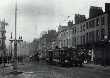
Toxteth c.1900
Use the slider in the top left to change the transparency of the old map.
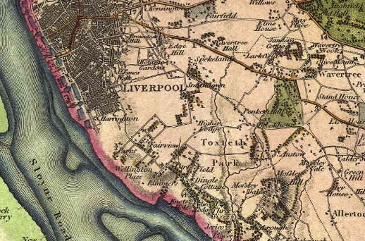
The Landscape of Toxteth Park
The landscape of Toxteth is undulating, rising to a peak at the north east, and there are three miles of waterfront. Toxteth lies to the south of Liverpool city centre. Before the Pool was filled in for the Old Dock travellers had to cross the Townsend Bridge, across the Moss Lake Brook, and past the Fall Well to get to the Park.
The flat areas between Parliament Street and Brownlow Hill are all that remains of the Moss Lake. The overflow from this lake, which powered a mill in the area, fed into a stream that flowed into the old Pool.
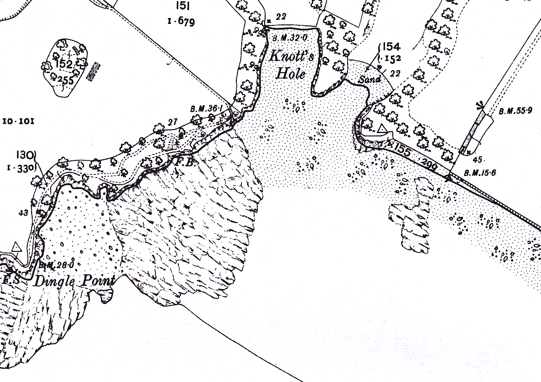
An important landmark in the area was the stream which flowed from the north east. It divided into two and flowed into the Mersey in the form of the Dingle, at an inlet called Knott's Hole, and the Otterspool, or Oskelbrook, a short distance further south.
Historically, the boundary of Toxteth Park ran from Queen's Dock on the Mersey, down Parliament and Upper Parliament Streets, across the junction with Smithdown Road and Lodge Lane to Penny Lane, then Queen's Drive and Aigburth Vale, before coming back to the Mersey at Otterspool.
Otterspool
Known as Osklebrok during the reign of King John, the Otterspool springs in Wavertree, and actually consists of two brooks. Otterspool was once quite a violent stream, falling 35 metres (120 feet) in just over 1km (1100 yards) many years ago. It was widened in the 19th Century for the lakes in Greenbank and Sefton Parks, and now runs under Aigburth Road at Vale and can be seen at gates of Otterspool Park.
Otterspool promenade was opened in 1950 using 30 million tonnes of rubbish and spoil from the Queensway Tunnel excavations. It was extended in 1984 with the 250 acre Garden Festival site, and is now part of the Sustrans cycle route.
Dingle
The Dingle, once known as Dickenson's Dingle, was a stream which flowed through St Michael's Hamlet, and the area nearby keeps the name of the old stream.
The Prehistoric and Roman Eras
Prehistory
As with the majority of Merseyside, very little is known of the Toxteth area before the Medieval period.
The Calder Stones are the oldest relics of human activity, and once formed a Neolithic burial mound in the vicinity of Calderstones Park, in the nearby township of Allerton. Another possible prehistoric monument is the Robin Hood Stone. Although its mythical connections are clear, this may be a standing stone, possibly existing in isolation or once part of the prehistoric landscape also occupied by the Calder Stones.
The Roman Occupation
The remains of a Roman road were uncovered in the 19th century near St Mary's in Grassendale, with the route also picked up close to the river in Otterspool some time later. However, very little Roman activity is known from the area west of the road running from Chester up through Warrington and towards Carlisle. The discovery of a small number of Roman coins attests to contact between Roman and local people, but more than that we cannot say.
The Medieval Period
The Early Medieval Period (Domesday Book)
By the time of the 10th Century AD, the township of Toxteth was divided into two manors, owned by the Saxon thegnes Bernulf and Stainulf. Toxteth was recorded in Domesday as just one of a handful of coastal settlements on the banks of the Mersey, along with the manor of Smithdown (Smeedon) inland, and Garston (Gerstun) to the south. The area was part of the Hundred of West Derby, given to Roger of Poictou by William the Conqueror for his loyalty in the invasion of 1066.
King John, increasing his holdings in the area after founding the borough of Liverpool, decided to take Toxteth back into Crown hands, and by 1212 we find that Richard, son of Thurstan, had been given Thingwall in an exchange with the King, who took Toxteth and incorporated it into his hunting forest, alongside Croxteth and Simonswood. It was John who enlarged Toxteth by adding Smithdown manor to it.
The Later Medieval Period (14th Century)
By the 14th century the park was fenced around as a Royal Park. The Park had two lodges - Upper and Lower - the first of which sat at what is now the junction between Sefton Park Road and Ullet Road (the entrance to Sefton Park). The Lower Lodge may have survived, in small pieces, near Jericho Farm, Fulwood Park, into the 20th century, and may have stood on the site of Otterspool Station.
The main entrance way to the park from the north, and Liverpool, was Park Road.
The land remained as a Royal hunting forest for around 300 years.
In 1316 the land was offered to Whalley Abbey, in order that they build a monastery there. The offer was never taken up, however, and the land is recorded as being in the possession of Liverpool Castle in 1327, and in the hands of the Molyneux family by 1346.
Early Modern Toxteth (16th Century - 18th Century)
The End of the Park and the Rise of Agriculture
At the end of the 16th century, actions were taken with the aim of dis-parking Toxteth. This would have allowed the locals to graze their animals on the land, a practise which already took place to some extent. Eventually, in 1604, Toxteth was indeed disparked by James I, although the bounding wall was still in existence as late as 1671. The disparking began the first major change in the landscape since the hunting forest was created in the 14th century. The conversion to arable and pasture land progressed rapidly.

The 17th century saw a number of settlers being attracted to the area to take advantage of the new farmland, from both Liverpool itself and beyond. The land was broken up into farms, and one of the most notable communities moved into the area: the Puritans. They settled in the area around Otterspool, dubbing the stream the 'Little Jordan', and the area the 'Holy Land', a name which is still often used. The Puritans built the Ancient Chapel of Toxteth (right) in the 1610s, appointing the 15 year old Richard Mather as the master of the attached school in 1611, and preacher in 1618.
By 1800 there were four farms on land leased from Lord Molyneux: Jericho and the Three Sixes in Fulwood Park, Parr's on Mill Street, and Rimmer's in Dingle Lane. As exploitation of the old Park went on, this number increased and the landscape took on a much more agricultural appearance.
The Rise of Industry
Small scale industry was also a growing feature by the 17th Century.
Mather's Dam was originally the site of a water mill on the east side of Warwick Street. This reservoir formed from a stream at the top of Upper Warwick Street, which ran across the road and down the slope to the River Mersey. The whole area here was laid out for houses once the stream ran dry in the 18th century, although the water remained standing for some years afterwards. The land between Warwick Street and Northill Street remained on a lease with the mill, but when this burned down in 1866, speculative builders moved in to develop the area.
Jackson's Dam, sited on the shore line on what is now Sefton Street, occupied the area from the bottom of Warwick Street, across Northumberland Street. The complex included a tide mill and reservoirs. By the second half of the 18th century, industry had become the dominant feature of the landscape.
At the end of the 19th Century, the stream feeding the mill at Otterspool was beginning to run dry. Around 1772 Charles Roe leased land nearby from the Earl of Sefton and built a small copper works. At this time there were only a few scattered residences on the road from Liverpool to Aigburth. A year later Yates and Perry's map shows seven large villas at the junction of Lodge Lane and Ullet Lane, as well as a large barn and a number of outbuildings associated with Lodge Farm. By the end of the decade requests were being made for a timber yard on Lord Sefton's land, a sign of the future importance of the timber trade in this part of the city.
Even in the following decade the former Toxteth Park itself was still exclusively rural, although the creeping urbanisation in the north was catching up with the boundary. Even by 1775 Old Park Road, Smithdown Lane, Lodge Lane and the eastern extent of Ullet Road were the only streets in the area.
New Liverpool
In 1771 the farm of Thomas Turner was laid out for streets by the Earl of Sefton, and an Act of Parliament was obtained by the Earl for the granting out of building leases. This made it possible for a Liverpool-born builder, Cuthbert Bisbrown, who lived in Paradise Street to plan 'New Liverpool', a town to be built on Sefton's lands to the south of the city.
This ambitious scheme was in competition with the cities of Bath and Edinburgh, which were both creating impressive Georgian landscapes at this time. The end result was the area known as Harrington, named after Isabella, the first Countess Sefton, and daughter of the 2nd Earl of Harrington. Unfortunately, finance at the time of the American War of Independence was scarce, and Bisbrown was bankrupt by February 1776.
Toxteth Terraces
The main streets created in the area were well built and wide, but Cuthbert's plans never addressed the infilling of the area, which was packed with poorly built and dense blocks of dingy courts and back-to-backs. As many people as possible were crammed into the space, with no thought beyond the profit of the builders, and some of the buildings had walls of half a brick thickness.
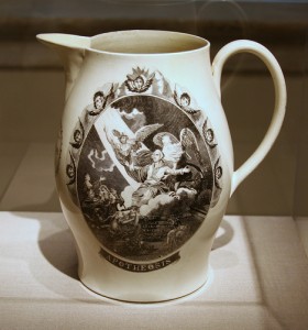
In 1794 the land occupied by Charles Roe's copper works was bought and converted into a pottery. In another two years this had become the Herculaneum Pottery Company of Worthington, Humble, Holland and others.
Although the pottery industry had declined in Liverpool at this time, the landscape around Toxteth provided water transport for the raw materials and products, as well as a market for the goods, and the factory did well. The surrounding district was developed to the advantage of the factory, including workshops surrounding the main site and a hamlet for the workers. The employees themselves were transported en masse from Staffordshire, well known for its expertise in the craft. The incomers were escorted into the area in November 1796, to the sound of band music and great celebration.
By 1811 there was still little further south than Northumberland Road, although the most rapid expansion in the wider region occurred in Toxteth Park, and Everton to the north, while other areas were losing population. The growing areas were Welsh heartlands in the city, attesting to the importance of this group to the growing Merseyside, and Toxteth was also becoming known as a 'Sailortown'.
Industrial expansion kept pace with the development of Toxteth, and in 1810 the Mersey Forge was founded on Grafton Street, near flour mills standing further inland. The forge later expanded into the Mersey Steel and Iron Company, and stood near the present Toxteth docklands. Brooke and Owen's brewery in Blair Street, only built in 1794, was dismantled in 1826 and the area covered with further terraces and courts.
The Toxteth docklands themselves were expanding in the area. Queen's Dock was constructed in 1796. Brunswick in 1811 and Coburg Docks were built in 1840, both for the expanding timber trade. Toxteth, Harrington and Herculaneum Docks were built on or near the site of the former Herculaneum Pottery, which was dismantled in 1833. Also on the riverside were shipbuilding yards, and a ferry terminal. From 1825-35 ropewalks were established in Lodge Lane.
The timber trade was certainly beginning to dominate the area, with large timber yards along Grafton and Caryl Street. Up to 1823 few buildings could be found south of Hill Street, but the construction of Brunswick Dock (1830), changed all this. By 1835 buildings had spring up as far as Northumberland Street, with few gaps left. By the end of the next decade the street had been extended as far as Wellington Road, and Mill Street was also lined with buildings. Park Road south of the Peacock Tavern (1812), Chester Street (1815) and Windsor Street (1823) were all created in this period. The population was by now growing rapidly and more densely, fuelled by the expanding timber trade and dock expansion.
Residential Expansion (18th - 19th Century)
New Roads and More Terraces
What Picton termed "pioneer cottages" had been built on the west side of Park Road by 1803; otherwise the area had consisted of green fields and stone walls.
Larger Georgian and Victorian houses were built along Princes Road, Princes Avenue (the Boulevard) and the Georgian Quarter in Canning over the coming decades. As William Leece mentions in a comment on this site: "the expansion of the city to the south of Upper Parliament Street and east of Mill Street seems to have paused for for several years before resuming in the 1850s and 60s. The road from what is now the Rialto to Princes Park (ie Princes Avenue etc) was laid out in the 1840s, but its character looks to have been semi-rural in the early days" (see comment on the Liverpool History Map page). Mill Street is first mentioned in the Directory of this year. Parliament Street, which got its name from an Act of Parliament granted to the Earl of Sefton for its laying out, had only four houses on it in 1790, and 21 residents. Up until 1807 the street terminated at a quarry on St. James Walk, where a windmill stood. In this year it was extended until it reached boundary with West Derby. However, growth in this area remained slow, and little more was built on it until the first years of the nineteenth century.
In 1822 the area of Windsor was laid out: the area enclosed by Parliament Street, Lodge Lane, Crown Street, and Upper Stanhope Street (now Beaumont Street) began to be developed. Lands west of this, known as the Parliament Fields and belonging to the Earl of Sefton, had demanded high prices and so avoided development as late as 1875.
Park Hill Road was opened up in 1824, and South Hill Road soon afterwards. In the beginning, these were lined with the large villas of wealthy residents, but later these were replaced with rows of smaller terraces. In 1826 Upper Stanhope Street, Upper Hill Street, Chester Street and Windsor Street were purchased from Lord Sefton by the Wesleyans, and laid out Wesley, Fletcher, Clarke and Newton Streets, and a Wesleyan Chapel was built in 1827. Park Street was laid out for houses in 1826, and John Hughes purchased yet more land from Lord Sefton, before laying it out for residential streets. Land between Princes Road and Warwick Street was first built on in 1830, and nearly covered as far as Upper Hill Street within twenty years. From Upper Hill Street to Upper Warwick Street followed between 1864 to 1868.
Population increase and Migration
During the 1840s dense housing communities expanded at an incredible rate. Back-to-back terraces accounted for 65-70% of the total housing in Liverpool in the 1840s. The population never increased by less than 60% in each census between 1801 and 1851: in 1844 Irish migrants arrived in great numbers, fleeing the Potato Famine, and the building of the Greek Church on the corner of Princes Road in 1870 attested to the growing importance of the Greek community in Liverpool.
Toxteth Becomes Part of Liverpool
This massive growth in Toxteth was by no means an unusual trend. Liverpool itself was expanding as a city, and the municipal boundary took in the northern portion of the Park in 1835, along with Kirkdale, Everton and parts of West Derby. In 1895 the remaining portion became part of the city. All in all the landscape of Toxteth's slums reflected that of any maritime town of this time concerned with commerce.
Former industrial areas were soon also given over to residential areas. Between 1849 and 1865, land south of the Welsh Congregational Church (land bought by Hughes) was converted from quarries to terraces. In 1860, land adjacent to the Liverpool and Harrington Waterworks (built in 1846) was laid out for housing, although land was slow to be built upon here. The roads were appropriately named after rivers.
19th Century Growth and Expansion
Toxteth continued to grow rapidly in the middle of the nineteenth century. Princes Road was laid out around 1846, soon after Princes Park, with Croxteth Road at around the same time. Green Heys Road was constructed in 1850, Grove Park commenced as a cul-de-sac in 1852, and Bentley Road appeared in 1862. Snowdon, Danube and Avon Street had appeared a year earlier. Northumberland and Park Street were built up around 1850, and Haslow Street in 1866 (then known as Egerton Street). The area from Park Street to Wellington Road was gradually built upon from 1850-70, close to one of the last windmills to stand in the area. To cope with the expanding population, 30 acres were set aside for Toxteth Cemetery in 1856, later enlarged to 40 acres.
However, not all the areas in Toxteth were crowding as fast as others. By 1875, from the bottom of Wellington Street and west of Grafton Street only ten cottages could be seen, and these the remnants of the Herculaneum Pottery hamlet. The area between South Hill Street and Dingle Lane were not yet built on densely: a scattering of large villas occupied the land, their gardens opening onto South Hill Grove, at the time a "verdant pasture". The western part of this tract of land was in fact still occupied by the estate of Park Hill House. The house at this time lay on the boundary between Liverpool and Toxteth, between the rural and the commercial. Dingle was known to be "one of the most lovely bits of scenery in the neighbourhood".
North Street (now Northill Street), High Park Street and South Street were only finally filling in by 1875 after standing empty for a time. Apart from a small number of good houses at the bottom of Upper Parliament Street, the area here was still vacant. In fact, towards the end of the nineteenth century, Toxteth, along with Everton and parts of West Derby, was losing population to other areas of Liverpool.
Parks
The cemetery was not the only open space in this part of the town. From 1864, over the next eight years, Liverpool Corporation created almost 500 acres of parkland for public use. Princes Park, laid out in 1843, was soon encircled by the large villas of the wealthy, first built on the east side. The Dingle was widened for the lake, and a red granite obelisk was erected to Richard Vaughan Yates, who had purchased the land for the park, in 1858. Otterspool was widened for the boating lakes in Sefton Park (created 1865) and Greenbank Park. Today the brook can be seen as it emerges from under Aigburth Road at the gates of Otterspool Park.
Transport
Transport became an issue for many cities in England while the inner city areas were growing with the Industrial Revolution. In 1869 the first horse-drawn tramway took passengers from the Dingle to Liverpool Town Hall. The Liverpool Overhead Railway had its southern terminus at Dingle. There were railway stations at St. James, St. Michael's and Sefton Park.
A ferry had been proposed as early as 1775, at around the time Bisbrown was planning New Liverpool, and a tavern and landing stage were built. The tavern was known as the Tall House, due to its loftiness and isolation in this undeveloped part of the region. Unfortunately, the scheme was before its time, and was eventually abandoned. The ferry station was used as a 'Ladies' School', later a tavern itself, and was demolished in 1844. In later years a ferry service began between the shore near the Tall House, taking passengers towards New Ferry.
20th Century Slum Clearance
The rapid expansion of Liverpool took its toll on the urban landscape. In 1955 the Medical Officer of Health estimated that there were 88,000 unfit dwellings in the city (45% of the total housing stock). Ten years later little had been done to tackle the problem, and the number was still 78,000. 33,000 of these houses were in Toxteth, Abercromby and Everton, and a massive programme of slum clearance was initiated. Rows and rows of uniform terraces were demolished, and replaced with high and low rise flats, new houses and maisonettes. Many people moved or were forced away from the area. 42 square miles of Liverpool were affected by the clearances, and 88 action areas were identified across Toxteth, Abercromby, Everton and Kirkdale.
Other regeneration projects began in the post-War era. Otterspool promenade was opened to the public in July 1950, constructed of 30 million tonnes of landfill and upcast from the Queensway tunnel.
However, unemployment had been increasing in the area due to containerisation of the docks. Tension existed between the black community and the local police force, and following a similar period of civil unrest in Brixton earlier that year, the Toxteth Riots broke out in July 1981.
In the wake of the violence, the Merseyside Development Corporation was formed in 1981 challenged with building the Garden Festival site: "a test of the continental model as a vehicle for the investment in resources targeting inner city development". A certain amount of optimism gripped those in Liverpool, but many were sceptical of the new developments. 180 new homes were built on the Garden Festival site, but the New Heartlands Project, a scheme set up to administer the urban regeneration, soon became a "euphemism for ripping the heart out of the city".
Nevertheless, in the quarter century up to 2000 a strategy based on tourism, leisure, housing and tertiary sector employment meant that the landscape along the shore, and indeed inland, was altering in a way never seen in this part of the city since the massive expansion in terraces, parkland and factories in the eighteenth and nineteenth centuries.
Further Reading
Many of the best resources for Toxteth history are the usual suspects:
- Toxteth on Wikipedia - brings together the history with the politics, geography and regeneration of the area. Also includes a list of 'Notable Residents'.
- Township of Toxteth Park - part of the Victoria County History of Lancashire (1907) is available in full on the British History website.
- The History of the Royal and Ancient Park of Toxteth - a reprint of a Victorian history from 'ancient times' up to about 1905. Enjoyable mostly for the romanticism of its approach to medieval history, and loose standards when declaring bits of old stone as 'doubtless the remains of King John's hunting lodge'.
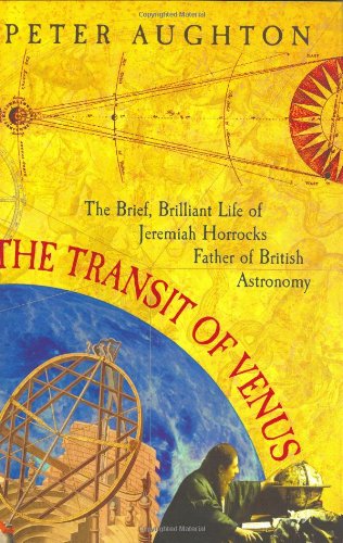
- The Transit of Venus (left) - a biography of Jeremiah Horrocks's short life. Horrocks was the first to predict the transit of Venus across the Sun, and although little known, made great progress in the field of astronomy.
Mapping the history of Liverpool
Old maps, interactive maps and the historic landscape of Merseyside.
Buy maps
Many of the maps on this site can be bought as high quality prints, either as paper or ready-framed.
You can also buy notebooks, postcards, greetings cards and other map-printed items!
Go to the shop to find out more
The book
Liverpool: a landscape history is a book about Liverpool and Merseyside from the very earliest days to the 21st century.
You’ll learn about everything from the Calderstones to the Capital of Culture.
Signed copies are available direct from me, the author, in the shop.
#ads

A set of three matching Cassini maps from three different periods, designed to appeal to anyone who wants to discover the hidden history of their local landscape.
- Cassini Old Series Maps first published between 1805 and 1874
- Cassini Revised New Series Maps first published between 1896 and 1904
- Cassini Popular Edition Maps first published between 1919 and 1926
Leave a comment
Derek Tunnington
08/25/2011 09:59:01
Reply to Derek Tunnington
Wendy Lagden
10/08/2011 22:03:15
I'm currently looking into my family history, my Grandfather worked at the Gold Seal Knitting Mill in Woolton betwen 1922-1927. I'm trying to find out anything about the place but so far have had no luck what so ever. Do you remember it at all? Any info would be bonus!
Kind Regards
Wendy
Reply to Wendy Lagden
Martin
10/19/2011 20:30:54
Thanks for your comment. I've forwarded it on to him hopefully he'll be able to respond to you. If you're a Facebook user you could also ask questions on the Historic Liverpool Facebook page.
Reply to Martin
Derek Tunnington
10/20/2011 09:12:58
Reply to Derek Tunnington
Nick Darracott
09/29/2012 01:53:57
My father George Darracott (Born 1912) lived in Ashcroft Street and his father was a Quay Carter on the docks.
I would be very interested in your memories of the area you describe I am not sure how far you are from the area of the docks, Ashcroft Street etc but any information of the area in 1927 -33 would be very interesting.
Many thanks
Kind regards
Nick
Reply to Nick Darracott
ann hory
10/23/2012 08:09:59
Ann
Reply to ann hory
Nick Darracott
12/16/2012 02:46:58
Profuse apologies for the delay in getting back to you,
I only check this site occasionally (shame on me!) and can only apologise even more.
I have relations in Canada, having said that, they were in contact in the 60's, Harriman, Vanstone, etc.
I have extensive Darracott family trees so maybe I could find your link somewhere.
You can contact me by email nickdarr1@btinternet.com or just Google Nick Darracott Cornwall and you will find my website (Pest Control) www.kilex.co.uk
Thank you very much for contacting me and I do hope we can share some information on the Liverpool you knew back then.
I look forward to your reply.
Kind regards
Nick Darracott
Reply to Nick Darracott
Nick Darracott
10/22/2021 22:28:11
Regards
Nick
Reply to Nick Darracott
Jenna darracott
10/07/2024 00:38:01
Reply to Jenna darracott
Jenna darracott
10/07/2024 00:42:19
Reply to Jenna darracott
Jenna
06/18/2025 19:40:17
Reply to Jenna
Pauline Griffiths
07/08/2020 12:28:26
Reply to Pauline Griffiths
Derek Tunnington
08/25/2011 10:06:11
Reply to Derek Tunnington
Nick Darracott
12/16/2012 02:55:11
Please excuse the very long delay, I completely forgot to re-check my comments.
Unfortunately I did not receive your reply, you may contact me on nickdarr1@btinternet.com at your convenience.
Many thanks
Regards
Nick Darracott
Reply to Nick Darracott
Martin Greaney
12/17/2012 11:39:08
Martin
Reply to Martin Greaney
MICHAEL QUIGLEY
10/02/2011 18:17:23
I RECENTLY PURCHASED FROM A CURIO SHOP IN LARK LANE A SEALED
STONEWARE FLAGON DATED 1935 WITH THE SAID NAME ON IT.
REGARDS
MJ QUIGLEY.
Reply to MICHAEL QUIGLEY
Martin
10/04/2011 20:58:14
This is quite a tough one. Is this similar to the kind of flagon you have? http://www.belowstairs.co.uk/acatalog/Online_Catalogue_Bottles___Stoneware_Flagons_57.html
I've found a reference to Perry the brewer in Pengwern Street near Princes Park in Toxteth, from Gore's Directory for 1900. This may be the company that made the bottle you have.
[It's on page 1128 of the 1900 Directory; search www.historicaldirectories.org.uk
Dock workers took flagons of beer with them to work - to keep them going! - as well as other manual workers. The docks, and the area of land just behind the docks were heavily industrialised parts of Liverpool right up until the Second World War. Many of these places still are.
What you have is one of the interesting little details that show what objects people were using every day. These flagons may have remained unchanged over decades - it's an interesting part of Liverpool's manual dock labour.
If anyone else reading this has any ideas, do add them below!
Reply to Martin
Andrea Ku
11/17/2011 17:53:54
I am researching into the population numbers of Toxteth from around 1850 to the late 1980s. Can you help with this? I understand they would be rough estimatins but anything is better than nothing. I am working with Growing Granby on Kingsley Road and we are having local workshops starting with the history of the area. Regards
Andrea
Reply to Andrea Ku
Martin
11/19/2011 13:46:44
There's a really useful population table on Visions of Britain for Toxteth here: http://www.visionofbritain.org.uk/data_cube_page.jsp?data_theme=T_POP&data_cube=N_TOT_POP&u_id=10583664&c_id=&add=N although it only goes from 1801 up to 1901. I've not been able to find more recent statistics.
The Vision of Britain site has a lot of statistics, but make sure you're looking at comparable figures, as this page http://www.visionofbritain.org.uk/place/place_units.jsp?p_id=1292 has a lot of different definitions of 'Toxtheth Park'!
Good luck with your research,
Martin
Reply to Martin
Andrea Ku
03/19/2012 18:10:15
Apologies for the delay response!
Regards
Andrea
Reply to Andrea Ku
Sue
12/24/2011 16:35:05
Reply to Sue
Martin
01/12/2012 11:50:55
I've posted a link to your question on the Historic Liverpool Facebook page to see if anyone there can shed any light on the area.
If you're after maps, have you tried http://old-maps.co.uk? Type in the co-ords boxes: 336784 and 389190 respectively, and press go. Click on the small maps in the right hand column to choose your dates. The fourth one down (1891 Town Plan) gives good coverage and detail of your area. Click on the main map once to zoom in.
For photographs, it might be best to try Googling for photos of Lodge Lane, as this is the closest main route to your area of interest. However, the Toxteth riots of 1981 mean there are a lot of images from that period. There's one evocative image of children in Lodge Lane on the Echo website: http://bit.ly/yu4pVQ.
Hope this info helps you get started.
Regards,
Martin
Reply to Martin
Linda Davies
07/11/2021 00:22:37
I was born a Davies. My nan and grandad (Davies) lived at 26 Twiss Street Dingle Liverpool 8. They had 7 children names George, Alexander, James, Pauline, Beryl, and Linda, and Robert was the youngest. They lived in Twiss Street in the 1930's i think. My nan died in 1969. My grandad died in 1974. They were named George Davies and Lilian Davies (nee Moore).
Reply to Linda Davies
Denise Jones
02/04/2012 12:53:53
Join us for a free* local history course
A community without equal:
the origins of Toxteth
Have you ever considered studying history? Why not give it a go with this 6-week course which explores the history of Toxteth, from its medieval origins to its development as a vibrant community over the centuries that followed. Paul Booth, a Liverpool University historian, will lead friendly, informal sessions which may include optional field trips to examine the landscape of Toxteth itself and to see key documents in the archives.
* Cost of fares for optional visit to Lancashire Record Office in Preston not included.
When: 2-4pm, Wednesdays, Feb 22 – March 28
Where: Toxteth Library, Windsor Street, L8
All welcome!
If you can, please register your intention to join us by calling into the Library in person or by telephoning 0151-233- 5428. If this is not possible, just come along to our first session. We look
forward to meeting you.
Continuing Education at the
Centre for Lifelong Learning,
University of Liverpool
www.liv.ac.uk/conted
Interesting fact
Henry VIII ordered a deer to be sent from Toxteth to the earl of Devon (The document with the king's signature on it is in Lancashire Record Office).
Reply to Denise Jones
Denise Jones
02/04/2012 12:56:50
Free to all
Reply to Denise Jones
terry eagles
04/24/2012 14:21:55
as arranged by Paul Booth re History of Toxtethe
Reply to terry eagles
Martin Greaney
04/24/2012 16:48:19
I'm not sure Paul Booth's talks (Wednesday, 2-4pm) are still running. This page seems to suggest they finished at the end of March.
I might be mistaken, so if there are other talks by him do let me know.
Martin
Reply to Martin Greaney
Lucy
06/30/2012 01:35:59
Would anyone happen to know where I might find some nice historic photos of Toxteth streets? Googling seems to get me nowhere so far! I'm looking to see where my Grandparents and Great Grandparents grew up - places like Windsor Street, Fletcher Street, South Chester/Chester Street, Clarke Street, Dexter Street, Warwick Street (they moved a heck of a lot!). I have no idea what kind of homes they might have lived in (slums or otherwise). The period 1890-1920 is of particular interest. Many thanks for any help you might be able to offer!
Kind regards, Lucy
Reply to Lucy
Martin Greaney
07/04/2012 17:37:53
There are a couple of maps on this site which cover the area, such as the Royal Atlas of England and Wales. That link takes you to the map centred around Windsor Street, with some of the other roads you mentioned visible nearby.
As usual, I can also recommend www.old-maps.co.uk, where you can search for your road. It has a detailed (1:1056) Ordnance Survey map of the area, showing that the houses were terraces, but don't look at all slum-like. They were modest, but perhaps the low end of middle class, perhaps upper end of working (so, clerks or other people in regular work).
There are photos of Windsor Street from 1962 here. They're much later than you were looking for, I know, but as with much of Liverpool in the 1960s, shockingly little has changed so you get a good impression (cobbled streets and all!). Hope this gets you on your way.
Regards,
Martin
Reply to Martin Greaney
ann hory
01/15/2013 06:48:53
Reply to ann hory
Matt O'Brien
11/14/2014 19:16:26
How well I knew your mothers little Shop on Hill Street Just around the corner from Tennyson Street what happy Memories.
If you can , please contact me at my email Address above
I live in Oshawa Ontario Canada, Best regards to all your family
Matt
Reply to Matt O'Brien
Maureen Womack
10/10/2020 03:13:35
Reply to Maureen Womack
Matt O'Brien
11/14/2014 19:23:18
Warm smiles I hope you get this
Matt
Reply to Matt O'Brien
Jayne Jones
07/18/2012 21:06:55
Can anyone help me with information about The Potteries area of Toxteth between 1851 - 1871. Researching my grandmothers family " Booths" .
Look forward to hearing from anyone.
Thank you
Reply to Jayne Jones
Martin Greaney
07/23/2012 21:47:34
I'm guessing you're referring to the site of the former 'Herculaneum Pottery', which was a factory where Ellerman Road now stands. This closed in 1841, and on the 1850 map the area is labelled with 'Pottery Beach' and 'Pottery Shore' which may be your Potteries.
The Herculaneum Dock was built on the shore there in 1864, and the houses nearby (homes to many of the dockers working at Herculaneum) were small terraces.
If you want to find out any more about the Pottery, then there's no shortage of stuff online, plus this great book, The Herculaneum Pottery: Liverpool's Forgotten Glory.
Hope this is something to get you started, but in any case the Potteries were typical of much of Toxteth in the Victorian period.
Regards,
Martin
Reply to Martin Greaney
Jean Sharpley
05/05/2022 13:35:42
Reply to Jean Sharpley
Carole Parkes
12/29/2022 19:45:59
I would love to know which Booth family you are researching.
Reply to Carole Parkes
Joe McLoughlin
11/10/2012 13:30:21
Reply to Joe McLoughlin
nora cole
03/25/2014 16:32:11
Reply to nora cole
Joe McLoughlin
08/04/2014 14:09:14
Reply to Joe McLoughlin
Peter Johnson
12/08/2016 19:52:50
Thank you,
Peter Johnson
Phoenix, Arizona
Reply to Peter Johnson
jimmy lloyd
12/08/2012 22:12:50
Reply to jimmy lloyd
Martin Greaney
12/25/2012 13:00:31
Kent Gardens was one of the many schemes built across Liverpool in the 1930s to deal with the housing problem of the times. Sir Lancelot Keay was the Director of Housing, so you could say it was he who built them, as part of the Council's schemes.
I'm not sure about how many people lived there, but there's a photo and a lot of memories on the Streets of Liverpool article about 'How the 1970s changed Liverpool' (as this was when many of these housing schemes began to be demolished).
Reply to Martin Greaney
ray greer
04/08/2014 14:17:07
Reply to ray greer
Margaret McHale
01/25/2013 19:44:49
Reply to Margaret McHale
Martin Greaney
01/27/2013 18:35:55
Lovely to see visitors to this site from all over the world!
I've not been able to track down a Baker Cottage, but there were certainly a lot of small houses in the vicinity, not marked with a name on the maps I have. Similarly with the brick fields. There were a lot of small-scale quarrying activities all over the area, taking clay, stone or sand out of the ground for building. There may well have been some in the area of Jericho Farm, but again the pits marked on the map are not labelled.
You're correct, this area of Liverpool is now Otterspool - if you have any more specific info on the location you're looking for then I'll explore further! :)
Regards,
Martin
Reply to Martin Greaney
Meg Ainsworth nee Bateman
02/16/2013 13:17:46
Reply to Meg Ainsworth nee Bateman
Craig Sharkey
03/04/2013 13:54:27
i am currently looking into St Patricks school on Park Place, i believe there is a large theatre in there which i think would be great to reopen, do you happen to have any information on the building or photographs at all?
thank you
Craig
Reply to Craig Sharkey
Martin Greaney
03/17/2013 13:27:43
Unfortunately I've not been able to find any old photos of the building, and it doesn't seem to be listed at all. Looking at old maps shows that the site was originally occupied by the Park Lane Brewery. It's difficult to tell on the small scale of the maps, but the building, labelled as 'Hall' in 1908 and 'Schools' in 1927, may or may not have been rebuilt. In any case, it looks like the school was first on the site in the 1920s. If I come across any information on the theatre inside (or anyone else has info on it) then I'll let you know.
Martin
Reply to Martin Greaney
@Liverpool1207
01/30/2014 22:37:27
Reply to @Liverpool1207
Martin Greaney
02/03/2014 16:55:25
Martin
Reply to Martin Greaney
Becky griffiths
07/16/2022 00:55:59
Was wondering if you could help me.
My grandad lived in 39 beloe st in dingle and im looking for old photos. I was told it was a small farm with chickens.
He served in the raf but come back to live with his parents who owned the farm before meeting my nan and them getting married then moving on to halewood.
I dont know much about my grandparents mother and father but i know they had a big family. This would of been during ww2. I know he left the farm in 1950 to move in with my nan. Would love to see where he came from and what it was like.
Thanks x
Reply to Becky griffiths
Martin Greaney
07/31/2022 09:25:01
Looking at old maps of the area I can see that there were some industrial-looking buildings behind the terraces of Beloe Street in the Victorian period. I don't know whether these were used as farm buildings (or were used for that later), but it's possible, as there's room. Then again, maybe the animals were kept somewhere else, maybe not far away?
The map can be seen here: https://maps.nls.uk/geo/explore/side-by-side/#zoom=19&lat=53.38128&lon=-2.96419&layers=117746211&right=ESRIWorld
Best wishes,
Martin
Reply to Martin Greaney
Lyndel Helm
03/13/2013 05:22:23
Reply to Lyndel Helm
Martin Greaney
03/17/2013 14:20:12
Beresford Road still exists in Toxteth, and can be seen on Google Maps. Liverpool had a lot of problems associated with overcrowding and disease, especially in places like Toxteth and Kirkdale (the latter in the north of the city). Rather than unemployment, the problem was of casual employment.
Men would go down to the docks every day, in the hopes that one of the dock masters would choose them for a day's work. Those not chosen would earn nothing that day. If you were strong, tall and healthy-looking, you had more chance of work. If you didn't fit this description, you might find it very difficult.
It may be that your ancestors grew tired of the daily trials, and saved up for the passage Down Under. You'll probably know better than me whether they found a better life in Sydney, though I suspect they did.
Housing quality varied, but the terraces still standing in the area look fairly good. Many perfectly decent houses were demolished by over-zealous 'slum' clearance projects in the 20th century, so it was likely your family lived in better conditions than many.
The 'Marmion Terrace' you mention was probably a name given to a row of houses on Beresford Road. It's a fairly long street, and even today you can see short stretches of buildings given their own name to make finding them a bit easier. Unfortunately these names are not on the map. The area all around Beresford Road was terraced houses, and the famous (and still standing) Florence Institute was close by.
Hope this gives you some extra detail for your research.
Regards,
Martin
Reply to Martin Greaney
Lyndel Helm
04/11/2013 07:41:29
Reply to Lyndel Helm
Colin Holland
05/27/2013 18:32:37
Reply to Colin Holland
Martin Greaney
05/28/2013 11:52:17
So true what you say about migration. Good to hear your memories of Marmion Terrace too.
Cheers,
Martin
Reply to Martin Greaney
Lyndel
04/06/2014 02:01:43
Reply to Lyndel
Chris simon
10/13/2013 15:12:44
Reply to Chris simon
Lyndel
04/06/2014 01:59:41
Reply to Lyndel
Maureen Wickham
10/05/2013 15:55:10
Reply to Maureen Wickham
Lyndel
04/06/2014 02:05:29
Reply to Lyndel
Fiona
03/31/2013 09:19:08
Reply to Fiona
Martin Greaney
04/08/2013 11:50:47
There are burial records for St. Peter's Church on the Lancashire Parish Clerks website. The same site, and map evidence, suggests there might not have been any burials at St. Cleopas. Looking at the map of St. Silas's Church High Park Street, Toxteth, suggests there were no burials there either.
Regards,
Martin
Reply to Martin Greaney
Maureen Wickham
10/05/2013 15:56:42
Reply to Maureen Wickham
donna carder
09/15/2013 22:23:50
Reply to donna carder
chris leckie
04/27/2016 17:46:47
chris
Reply to chris leckie
Ruth Thomas
04/01/2013 15:02:05
Thanks for any help.
Reply to Ruth Thomas
Martin Greaney
04/08/2013 11:58:59
Try this blog post which has some photos of The Beatles playing in Rosebery Street. Some of the non-Beatles photos don't show the street in its heyday, but might be of interest. Some of the photos from Paul Trevor's exhibition Like You've Never Been Away show Mozart Street, again in the years close to redevelopment.
Regards,
Martin
Reply to Martin Greaney
Ruth Thomas
04/09/2013 15:05:44
I had already found the photos you suggested but I will keep looking for others.
Best wishes
Ruth
Reply to Ruth Thomas
Sue
04/16/2013 04:48:49
Reply to Sue
Martin Greaney
04/17/2013 18:37:56
Thanks for telling us about your father's memories! Oriel Road used to be in the middle of a tangle of railway lines that took goods and passengers to the dockland areas of North Liverpool, so I'm not surprised that trains were such a landmark in the area. You can see some of the area on the Plan of South Liverpool, 1890 in square A4. Oriel Road is the street where you can just see 'Road' coming in from the top left.
Martin
Reply to Martin Greaney
Caroline
05/06/2013 11:47:52
I am researching my family tree 'McCartney' from Liverpool (no not Paul). I have managed to obtain an address from my Grandfather's military documents but have been unable to find it - 5 Sedan Street, Toxteth Park. I can't find it on any map that I have looked at, yet can see lots of references to it in other historical records). I am just wondering if you have any idea of where it may be located.
Many thanks, Caroline
Reply to Caroline
Martin Greaney
05/09/2013 17:46:23
I'm as stumped as you! I've found lots of references on cemetery records and on discussion forums, but few clues as to where Sedan Street is! Putting the clues together, we might be able to tell a few things about the road. As people often lived close to their parents in the Victorian era (I know - not your grandfather's time, but bear with me!), looking at those cemetery records would suggest that the road is somewhere around the north west of Princes Park, near Harlow Street. Also, looking at this record of a Thomas Brown who at one time lived in Sedan Street, and seeing that he moved in the 1960s to Kirkby, it can be suggested with some confidence that Sedan was demolished in the middle of the last century and the residents moved to new council estates. Although a lot of decent quality housing was demolished, the Princes Park area I mentioned has a lot of unmarked back lanes and streets, which would have had very small dwellings on them.
I wonder if Sedan Street was amongst these unnamed roads here, or perhaps this group of roads a little further from Princes Park.
Sorry I can't be more helpful, but hopefully it gives an idea of the kind of place your grandfather lived in.
Regards,
Martin
Reply to Martin Greaney
Caroline
07/10/2015 10:49:09
I am so sorry for the late reply, I lost track of where I had posted my message and have only just found it again. It's good to know that the street existed on other records and it looks like Colin has pinpointed the spot. Great timing as my Mum is heading home to Liverpool for a visit in September.
Thank you so much for your help,
Caroline
Reply to Caroline
Martin Greaney
05/09/2013 20:48:31
My partner, Sue, more of an expert on censuses and enumeration districts, found a census page which covers an area bounded "on the north by the middle of Upper Park Street and ?Waller Street, on the east by the middle of Windsor Street, on the south by the middle of North Hill Street and Harlow Street, and on the west by the middle of Mill Street." (Census reference RG13/3432, Toxteth Park, 1903, ennumeration district 44).
So I think Sedan Street is one of the group of unnamed roads off the south side of Rhyl Street. Hope this helps!
Regards,
Martin
Reply to Martin Greaney
Colin Holland
05/27/2013 19:09:23
Reply to Colin Holland
Caroline
07/10/2015 10:55:50
Better late than never but thank you so much for this information. I had spent many hours on this and had given up. That location makes sense as most of the family seemed to be located around Park Road and ended up in Beresford Road.
Cheers,
Caroline
Reply to Caroline
Cathy Star
05/15/2013 14:45:48
Reply to Cathy Star
kenneth redfern
08/08/2013 18:28:04
Reply to kenneth redfern
Martin Greaney
08/21/2013 17:54:17
Thanks for your question. I've not found any photos of Stanhope Cottages myself, but perhaps someone on the Historic Liverpool Facebook page can help. They folks on there are usually a great source for photos.
Regards,
Martin
Reply to Martin Greaney
Jayne M
08/09/2013 22:18:41
I'm trying to find any information about Cotter Street, Toxteth. My great grand parents lived there... Joseph and Mary Kelly (Kirkham)
From what I can gather it isn't there anymore and I've tried for months to find a picture. I checked a map posted fuher up this page and found the street (if the right one) is very small so even a longer shot than I first thought!! Any info or help would be brilliant.
Thanks
Jayne.
Reply to Jayne M
Martin Greaney
08/21/2013 19:53:02
You're right, this was a very small road! The place where it once stood is now a park between Mill Street and St James Place. Old Maps show that the houses were very small on that street, and the area was gradually demolished in the 1960s and 1970s. I've put a map of Cotter Street up here (click for a larger version).
Regards,
Martin
Reply to Martin Greaney
Julie
05/28/2022 01:15:10
I know this is probably a long shot but I saw your reply a few years ago now to Jayne about Cotter Street. My ancestors also lived in Cotter Street in the 1860's their address being 4 Court, Cotton Street. I've looked everywhere for a map which shows 4 Court and wondered if you still had access to the map to see if it's on there? I'd be most grateful for your help if you still have the map.
Kindest regards
Julie
Reply to Julie
Martin Greaney
06/17/2022 11:36:06
I've found this map on the National Library of Scotland. It doesn't number every court unfortunately, but might be a start in your research. I wonder whether Court 4 is the large area in the centre: https://maps.nls.uk/geo/explore/side-by-side/#zoom=20&lat=53.39263&lon=-2.97402&layers=117746211&right=ESRIWorld
Best wishes,
Martin
Reply to Martin Greaney
Sue Colley
08/14/2013 05:05:26
I have given my dad a printout of this, not sure how much he has read but he has recounted an incident he witnessed at Potter's Barn involving a plane shot down on 10th September 1939. Do you know of anything of it. I havent been able to find anything on the internet.
Cheers
Sue
Reply to Sue Colley
Martin Greaney
08/21/2013 19:59:05
No, I've not been able to find out anything about this incident, and haven't heard of it before. I'd love to hear from someone else who might remember it, if they're reading this!
Regards,
Martin
Reply to Martin Greaney
Martin Greaney
08/22/2013 10:28:10
Could your dad be mixing up Potter's Barn with Potter's Bar? http://www.brookmans.com/history/features/zeppelin/
Martin
Reply to Martin Greaney
Ron Jones
08/19/2013 13:04:31
Reply to Ron Jones
Jenny Booth
07/10/2016 22:39:05
My family are too looking into finding more about Nicholas and Mary Baker. My great grandfather was Joseph Baker! Please get in touch if you can,
Jenny
Reply to Jenny Booth
Johnny Mac
08/28/2013 11:08:44
I have been tracing my father s education and there was no mention of his secondary school and assumed St Malachyes was from age 5- to 15. but unsure...
thank you
Reply to Johnny Mac
Martin Greaney
09/01/2013 15:03:41
From what I can tell, St. Malachy's was just a primary school. All references to it seem to only mention Primary.
Regards,
Martin
Reply to Martin Greaney
Johnny Mac
09/09/2013 12:32:28
thank you for the note.
regards
Johnny
Reply to Johnny Mac
Marie
03/12/2014 11:58:10
Re your query about your Dad's schooling, St. Malachy's was in Beaufort Street and also Robertson Street (Boys) Liverpool 8. My parents were educated there (1930's/1940's so now aged 80+) until the age of 15, but when I attended (1960's now aged late 50's) it was up to age 11, when boys went to the "new" secondary school St. George's in Mill Street (and girls to St. Winefride's in Park Street) now demolished. The other local secondary school was St. Martin's which took children from St. Patrick's Park Road. Hope this helps!
Regards
Marie
Reply to Marie
Lorraine Edison
01/05/2014 20:47:48
Reply to Lorraine Edison
arthur robinson
10/09/2013 22:52:16
Reply to arthur robinson
Gaynor
10/13/2013 17:26:25
Reply to Gaynor
Norma Rimington
10/17/2013 14:01:57
Just a note to say I have found this site fascinating!
My mother was a Perry and my dad a Ward. We lived in Sefton Square, off High Park Street, in the 50s and 60s. Notable landmarks were: St Peter's Methodist Church, the Town Hall (I think) which I recall as being the National Assistance Office, Toxteth Reservoir on the corner of Letitia Street, Mount Camel RC Church, Princes Park, the Gaumont picture house, Wellington Road Secondary Modern, the pub on Park Road opposite Wellington Road which locally was known as Knob 'ill - I never knew it's real name!
I have a reasonably good knowledge and memories of the area so if I can help anyone else in filling in the odd blank, I'd be happy to try.
Once again, love the site!
Reply to Norma Rimington
Martin Greaney
10/17/2013 14:35:29
Martin
Reply to Martin Greaney
John Shaw
05/26/2014 20:47:18
Reply to John Shaw
Norma Rimington
07/22/2014 23:15:00
Sorry for the late reply but, like many others, I'm not a very regular internetter! I'm sorry I'm not able to help you with your mate but do hope that somebody else recognises the names you mention and helps you out.
Good luck with the search.
Norma Rimington (nee Ward)
Reply to Norma Rimington
Catherine McCullough
03/16/2016 14:25:53
Reply to Catherine McCullough
Alexandra Nuttall
08/09/2014 14:16:37
I would be very grateful if you could contact me
Alexandra
Reply to Alexandra Nuttall
john fisher
12/28/2016 14:10:52
Reply to john fisher
Eileen Wood nee Bache
10/03/2017 17:30:33
Reply to Eileen Wood nee Bache
Norma Rimington
11/06/2021 22:59:35
Yes, George was my mum Joan's younger brother. George died in the late '90s.
Reply to Norma Rimington
Eileen Wood nee Bache
10/03/2017 17:27:48
Reply to Eileen Wood nee Bache
LYNDON THOMAS
06/27/2021 12:24:33
I'm reading a biography of Billy Fury which states the first home he lived in when he was born in 1940 was in Sefton Square. I guess it's long gone, but where exactly was Sefton Square located i.e. what's there now?
Thanks
Reply to LYNDON THOMAS
Martin Greaney
07/06/2021 18:21:51
Sefton Square joined onto Roper Street (which is still there) - you can search for it on this page, and this link goes straight to Sefton Square: https://historic-liverpool.co.uk/interactive-maps/old-streets-liverpool/#17/53.38590/-2.96551
Best wishes,
Martin
Reply to Martin Greaney
Norma Rimington
11/06/2021 23:18:31
I know that Ronnie Wycherley / Billy Fury lived in Haliburton Street but for some reason lived for some time as a baby in 2 Sefton Square, where my grandparents lived (Joe and Ethel Perry). His mum (not sure about his dad) had reason to live in the parlour for a while. The parlour window looked out onto High Park Street and you could see straight down Digby Street opposite. The first street crossing Digby Street was Collins Street, and the next one down was Haliburton Street.
There was - and I think still is now - a Job Centre built over the footprint of our old house/Sefton Square.
Precise location of Sefton Square AS WAS: if you turned onto High Park Street from Park Road, pass St Peter's Methodist church on the left (which I think has now been converted to apartments), then there were two terraced houses, then Sefton Square. Further on, another two or three terraced houses, then what I knew then to be the National Assistance office but I think is a town hall.
Reply to Norma Rimington
Norma Rimington
11/06/2021 23:37:49
I had mistakenly thought that "Billy Fury" was actually born in our front parlour - at least that's what my mum told me. However, somebody on another site (can't remember where) told me that they had obtained a copy birth certificate for him which showed that he was born in hospital. Was it the Southern?
Reply to Norma Rimington
Norma Rimington
11/06/2021 22:54:07
Better late than never I hope.
Mrs Perry at No. 2 would have been my grandmother, Ethel, married to Joseph "Joe". Their children were: John, Joan (my mum), and George, the youngest. My nan Ethel died of a heart attack in around 1954 - she was only in her mid-forties. My mum had married Chris Ward (from Park Hill Road) in 1953 and moved to a flat over a pub on Kirkdale Road. Their first daughter, Christine, was born in 1954 but died at 2-months old. I was born in 1956 and when I was 5 in 1961 they moved back to 2 Sefton Square where my granddad still lived. We stayed there until 1969.
If you lived up by the wall you might remember Billy and Brenda (Mallon or Mahon) who had a daughter, Jean. If I'm not mistaken, they would have been your next-door-neighbours or next-door-but-one. They had relatives just across the street, the Reids. Tommy and Kenny Reid were Jean's cousins and I'm almost certain their mum was a Brenda too. (I recall my mum and their mum running the street's tontine for a while.)
Half-way down on the 0dd-numbered side was a couple named George and Annie Roughley. They had a little girl and named her Joan after my mum. My mum and Annie used to go the bingo on the corner of Beresford Road - when they could afford it.
At number 1 Sefton Square, opposite us, was a very nice couple named Mr & Mrs Graves. They had two sons, Richard and Kenneth. As far as I remember, they were the only family in the street who had a car - for a long time anyway. (My dad eventually got a motorbike and sidecar, then a Reliant three-wheeler while we were there.) Mrs Graves used to give me a threepenny bit to scrub her front step and polish the brassware.
Yes, there are very few mentions of Sefton Square. I know our house had many failings - freezing cold, damp, constantly leaky roof, etc - and we had next to nothing but it was a good, solid upbringing. I wouldn't change it for the world. I like to remember and mention Sefton Square whenever I can and as often as I can.
Reply to Norma Rimington
Mrs Patricia Allerton (nee Kelly)
07/16/2020 15:32:06
I know you post was a long time ago but just a long shot . You say that your family lived around Letitia St in 1950's , I am trying to find anyone who may have known my Grandmother Mary Kelly who lived with her sister Sarah McGinley in number 50 Letitia St in the 1950's .
Any help would be really welcome
Thank you
Reply to Mrs Patricia Allerton (nee Kelly)
Norma Rimington
11/06/2021 23:32:21
I'm sorry I'm unable to help you. Even though we lived very near to Letitia Street my recollections of it are few. I walked up and down it to and from school (Upper Park Street). I remember in the early '60s some new houses being built on the left-hand side walking down from the reservoir. A schoolfriend's (Edith Livingstone) family moved into on of them from Combermere Street.
I hope you can find the information you need.
Reply to Norma Rimington
Mrs P Allerton
01/16/2022 16:38:14
Thanks so much for your reply !
Pat
Reply to Mrs P Allerton
Andrew Carr
12/11/2013 12:17:49
My uncle Peter Hogg say there was a plaque about honor.. ? Do you have any traces of the Hogg family there?
Reply to Andrew Carr
Martin Greaney
12/12/2013 18:57:57
I'm afraid I'm not much of a family history expert; I know more about the built history of Liverpool. However, if anyone else reading this knows of the family history of the farm, then do add a comment below!
Martin
Reply to Martin Greaney
roy rogers
02/13/2014 17:16:42
Reply to roy rogers
Susan
04/28/2014 17:40:32
I am trying to find out about my grandmother who died when my mother was small and my mom has passed too and I have no info other than her name, Jean Hogg born April 10, 1892. Have been trying to track down family members on that side. She was from the Liverpool area as well. If you have any info or maybe if she may possibly be related, please let me know! Thanks! Susan
htownprop@gmail.com
Reply to Susan
Ann Robinson Ahlgren
06/02/2014 21:23:12
Quite by chance I saw your letter here. I lived in the next street to Mr Hogg's dairy. I lived in Rosslyn St and his dairy was in Alwyn St on the corner of Bryanston Road. When I was big enough to carry a jug I was sent to the dairy to fetch a pint or a quart of milk. I had to be careful not to spill it. There was often a cloth to put on the jug to keep any dirt out. The family was very pleasant. They remembered names and always smiled pleasantly. They had 2 children Angela and ? June. Angela had red hair!
At the back of the shop there was a place for some cows which I think were brought from Jericho Lane to give milk on the spot so to say. Then they were replaced. When I went to school there was a kind of wall grid allowing one to see into the cow shed. I specially remember the smell from this and also the wonderful clean smell of the shop, which was mainly white and attractive.
My mother took me to Jericho farm when I was little ... it was close to the river Mersey. I do not know anything about a plaque however. It was fun to relive my memories! sincerely Ann Robinson Ahlgren
Reply to Ann Robinson Ahlgren
Jan
08/10/2017 09:10:02
Reply to Jan
Louise
07/10/2020 00:21:33
Reply to Louise
Caroline Jackson
04/25/2016 01:51:44
Reply to Caroline Jackson
Martin
04/25/2016 16:44:52
The red cow at Otterspool is a Brahman Bull, and came originally from the Garden Festival site. It was designed by Dhruva Mistry
Martin
Reply to Martin
Ruth Punshon
11/13/2017 21:58:14
My grandmother Ellen Hogg, was born in 1883 at 16 Aigburth View, Toxteth Park and her father John Hogg was the cousin of John Hogg of 3 Little Parkfield Rd & Jericho Farm.
We have traced this Hogg line [including your Robert] back to Tristram Hogg [1738-1832] & Eleanor Falshaw [1754-1840]
If this is of interest & you would like any further details please get back to us.
Regards
Ruth.
Reply to Ruth Punshon
Lyndel Helm
04/06/2014 02:10:07
Reply to Lyndel Helm
arthur robinson
05/08/2014 01:25:35
Reply to arthur robinson
Maria O'Rourke
05/10/2014 00:00:37
Reply to Maria O'Rourke
R.M.Healey
06/23/2014 15:18:03
I would be delighted to hear from anyone with special knowledge of the social history of this part of Toxteth in the period specified.
University of Liverpool
Reply to R.M.Healey
Melanie
07/14/2014 10:29:04
Reply to Melanie
Dave O'Brien
08/04/2014 23:56:44
I was a paper boy for Lenny Jones who had a newsagent on High Park Street., Liverpool 8. It was around 1961. I'm trying to find a picture of the shop and also of anybody who worked there at the same time. Cheers Dave OB
Reply to Dave O'Brien
June Francis
08/26/2014 14:42:26
I've just read all the mails and your input on this site with great interest. I'm a Liverpool novelist and grew up in the West Derby Road area and now live near Crosby. Like many of the mailers I've spent some time tracing my family tree and discovered that a number of my Victorian ancestors settled in Toxteth as carters, builders, porters and mariners. Some brought their women with them and many married Liverpool lasses. I can relate with so many of those writing in, fascinating. I am planning on writing a book called And They Came To Liverpool about my own ancestry and family life growing up in the city and how it's impinged on my writing, so really appreciate sites such as this one. Keep up the good work.
Reply to June Francis
Martin Greaney
08/29/2014 12:04:16
Thanks so much for your comments - it's always nice to hear people enjoy the site! As a writer myself, I can empathise with how the city can be inspirational, especially the varied landscapes here - suburbia, city centre, Victorian slums and modern towers. I'd certainly be interested in reading a novel about Liverpool migration (though I've never had a look at the popular Helen Forrester novels), so good luck with that!
Martin
Reply to Martin Greaney
Graham Thomas
09/04/2014 17:55:42
Reply to Graham Thomas
Martin Greaney
09/08/2014 14:08:32
That's great! A lot of work's gone into that article. Shame the history ends in demolition but it's lucky you've got a good photo to illustrate it.
Martin
Reply to Martin Greaney
Graham Thomas
09/19/2014 17:08:35
Graham
Reply to Graham Thomas
Mary Ludden
10/30/2014 14:17:11
Your website is fascinating - I never knew about the little Toxteth chapel - did the stone come from the quarry where St James Cemetery was laid out? Regards Mary Ludden
P.S. don't worry if you haven't got time to reply, you must get swamped by your website whereas I have nothing better to do with my time!
Reply to Mary Ludden
Martin Greaney
11/05/2014 20:06:53
I've not heard the reference to Hope Farm, though I've seen a lot of varied ideas about many place names and road names in Liverpool, so it wouldn't surprise me if it was in a Victorian history somewhere. It's now said that it was named after William Hope, whose house stood on the site now occupied by the Philharmonic Hall. I can't find a map showing the house, however, so I'm not sure what the source for this info is.
Glad you like the website! The Toxteth chapel may have got its stone from a quarry closer than the one at the cathedral as there were several around the city.
Martin
Reply to Martin Greaney
Evan Jones
11/10/2014 02:33:57
They were married in November 1820 at St Anne Richmond. They had (it appears) 7 children.
Reece is listed as a shipwright (as was Mary's father). They lived variously on Norfolk Street, Lawton St, Pownall St (where Mary was born), Lower Harrington St, then finally on Wellington Road.
A correspondent has found a reference on Lancat to Reece's death in 1851, and in the Liverpool Mercury on 8 January 1879 to the death of Mary, 3 January, aged 81, residing at 70 Wellington Road, Toxteth Park.
Of the children, Joseph Reece Jones (my greater grandfather) migrated to Melbourne (as did John and one of the Marys), and Hannah migrated to New Zealand.
I'm trying to track down the birth details of Reece Jones, but nothing is available on the web or on ancestry.com.
Ironically, I live on Toxteth Road, in a inner suburb of Sydney called Glebe. An emigrant, George Allen, soon (with his children) to become colonial grandees, was granted the area and built an imposing mansion in an estate that he called Toxteth Park. Hence the street (and later a pub, so named, in spite of the Allens' extreme methodism).
Reply to Evan Jones
Martin Greaney
11/10/2014 10:43:08
Thanks for your information, and good luck in tracking down those final details about Reese. I was really interested in looking up Toxteth Road, Sydney - it looks so English except for the odd whitewashed villa and the intense sunshine! I'm always fascinated to spot Liverpool names in former colonies, and see how the links work.
Regards,
Martin
Reply to Martin Greaney
Lynda McCarthy
04/02/2016 23:31:55
Reply to Lynda McCarthy
John Penton
01/13/2017 18:43:20
My grandfather worked in the engine room for Cunard and sailed on the Queen Mary, but at the outbreak of war, as he was in the RNVR, he was called up by the Royal Navy - he was killed in the North Atlantic in 1941. My father was nine years old.
My father, Charlie, went to Beaufort Street school, the Florence Institute and was in the Boys Brigade, I think St Gabriels.
He moved to Sydney with my mother in 1990 and died there in 2005. My Mother, nee Josie Slocombe, also died in Sydney in 2016.
Reply to John Penton
A Bates
03/28/2017 23:11:26
Reply to A Bates
Martin
05/19/2017 16:32:45
I can't find any Hythe in the area, but I wonder whether it could have been a bad transcription of Hyde in Manchester?
Martin
Reply to Martin
christopher caryl
05/25/2017 16:53:15
thank you
chris caryl
Reply to christopher caryl
Martin
05/30/2017 16:27:45
Caryl Molyneux was the 3rd Viscount Molyneux (1623/1624–1700, of the family that later became Earls of Sefton at Croxteth Hall), and who owned the land in Toxteth. Caryl Street is named after him, and this street was where they built Caryl Gardens. The street was much older, though.
Martin
Reply to Martin
Dave Hodges
03/25/2025 23:03:40
My Mum lived at 9 Brassey Street and I visited there as a kid in the earlier 1970’s. Her Granddad had stables around the corner or near by. I’m looking for any info and pics as I remember playing at the concrete boat. I have find a pic of that but a pic of the whole area would be a treasure find . Mum is 89 now and the stories are amazing. Thanks Dave
Reply to Dave Hodges
david richard fitzgibbon
10/28/2017 06:38:10
Reply to david richard fitzgibbon
lesley saunders
02/26/2018 18:46:02
Reply to lesley saunders
Meme man
04/05/2018 19:03:16
Reply to Meme man
John Shaw
06/08/2018 21:51:11
Reply to John Shaw
Adrian Boerstra
12/09/2021 02:29:22
Reply to Adrian Boerstra
John Shaw
12/11/2021 11:59:38
Reply to John Shaw
Linda Corbett
09/25/2018 21:02:57
Does anybody have any memories or photos of Twiss Street Dingle, Liverpool. My nan and grandad lived there, and there names were Davies. They brought 7 children up there. My nan and grandad were Lilian and George Davies they lived at number 26 Twiss Street. I think they were there from about 1930 ish maybe before. They were living there in 1969. Then my nan died and it was demolished. Please if anyone remembers them could you let me have any memories you may have.
There was a pub on the end of the road, i do not know what it was called. It was an old pub, does anybody remember it? It was at the end of Twiss Street, Dingle.
Reply to Linda Corbett
Dee Cole
12/30/2021 19:43:03
My best friend Susan Murray lived in twiss Street just backing on to us, they kept rabbits, her Mum's name was Eileen !, there was also a Mr Omo living at the far end of twiss Street !, not many cars about back then we had one in our street, so us kids could play out ! .
We had a pub at the top of our street called the Old Stingo !, Monaghans the paper shop on the other corner top of High Park Street.
Oh & everyone had a tin bath hanging in the yard !.
Our house or the back of it fell down one night about 1966 & we moved out, loved my childhood there Xx
Reply to Dee Cole
Linda Corbett
12/30/2021 20:00:22
Firstly, what a lovely message, yes, that is all what i remember about the inside of the house. A lovely marble fireplace with a coal fire. Only heating in the house, it was freezing, and a tiny kitchen and a back yard with outside toilet like you said. Lovely friendly people lived there, my nan and grandad loved that house, and brought 7 kids up there. How did they do that?
Also, the pub on the end of Twiss Street, did you say it was called The Stingo? I remember it. The other side of the street was a sweet shop, nana used to give us pennies, and we would go and get sweets there. She would buy us chips as well, but can not remember the chip shop, where it was. Good happy memories, nobody had much, but all happy and content with what they had.
My nan died in 1969 and then my grandad left to live with a family member. So they never moved together anywhere else, i do not think they would have liked it anywhere else though, they just loved Twiss Street.
In the blitz my grandad lost his father named William Davies who lived in Greta Street, i think my dad said it was number 10. He died on way to air raid shelter, he went back in for his daughter Violet Davies, and a bomb hit the house, before they could get to safety. My dad said my grandad was heartbroken. They died together, my great grandad, and his daughter Violet. So i have heard of Greta Street through my dad. I have lost my mum and dad now, aged 75 and 67. You never stop missing them, but it was a different life back then, such happy times.Always a pot of tea on, and something to eat. Any other memories will you tell me about them.
Thanks for the info...........Love Linda xx My mum was from 125 High Park Street, Dingle. They both grew up in the Dingle............thanks for letting me know this....keep safe......happy new year Dee x
Reply to Linda Corbett
Suzanne Watson
07/23/2023 17:24:32
My dads family the Wilson’s lives in 24 Greta street. Do you remember them at all ?
Reply to Suzanne Watson
Louise
07/10/2020 00:40:00
Reply to Louise
MAUREEN GINER
08/07/2020 15:03:28
Reply to MAUREEN GINER
Martin
08/10/2020 11:16:41
Geraint Street and the block from the corner of Windsor Street and North Hill Street up to Princes Road shows as fields on the 1850-1 OS map. The streets are present on the 1890-3 map. There's a good jumping-off place for resources to research houses here: https://historicengland.org.uk/advice/your-home/your-homes-history/how-to-find-out/
Regards,
Martin
Reply to Martin
Eric Smith
01/08/2021 01:12:45
Reply to Eric Smith
Jonathan Connor
03/20/2021 15:07:51
My dads family lived in Liverpool. I have only been able to trace to my granny (she died before I was born). My dad was a Connor (Francis). Born 1917. He was one of 5 children born to Florence (my grannies name). She was married to a Henry Lightfoot, her maiden name was Howell. All my dads siblings had the surname Lightfoot, he was the only Connor. I assume my granny married twice. Henry was a shipwright. Luke Street was the family address in the 1911 census.
My dads sibling names were; Jessie, George, Marjorie and Dorothy (Dolly). I believe he had another brother who unfortunately died when very young, I don’t know his name.
If anyone knows anything about the Lightfoot or Connors of this era and area of Liverpool I’d love to find out more. I am struggling to find out very much about my family. I’d really appreciate any information that anybody may have.
Reply to Jonathan Connor
John Gore
05/18/2021 10:28:43
Just stumbled across this site, very interesting, I remember as a child in the 60's my Dad worked for A.S Jones Ltd , a Tanker company who transported Hazardous chemicals amongst other things, their depot was in South hill Road L8, Dad used to take me to work with him on Saturday mornings when the depot was quiet, he was an HGV mechanic. The depot in South hill road was surrounded by houses and large tenements, it is hard to imagine these dangerous chemicals being in such close proximity to housing. My question is, does anyone know of a site which has photographs of South Hill road at this time, and or the premises of A.S Jones Ltd.
Kind Regards
John
Reply to John Gore
Anthea O’Dea
02/20/2022 02:30:12
Have got a lot of information.and putting it together but my brick wall is , Jonathan Potter, born 1885 , married Jessie Abernathy in 1908 and had 6 children, the last one born in 1925. Jonathan was the son of Joseph Potter, born 1846 and Elizabeth Threlfall born 1856.
I have a birth certificate of one of Jonathan’s children, Thomas Henry, born 1920 in Egremont Cheshire. In 1920 Jonathan was listed as being a “ flatman”, as his occupation on the birth certificate of Thomas. I have searched almost every available web site for genealogy to try to find a date of death, place of death for Jonathan Potter, …no luck. Hoping someone reading this may know, may be able to help.
Reply to Anthea O’Dea
Saskia Steinhorst
12/17/2022 21:24:52
Reply to Saskia Steinhorst
Zara Lloyd
03/24/2023 11:04:20
Reply to Zara Lloyd
Steve O'Donnell
01/24/2024 14:45:41
Reply to Steve O'Donnell
DAVID GREGGS
03/27/2024 21:26:29
Reply to DAVID GREGGS
Janet Foulds
02/21/2025 18:18:19
I have been doing my family tree for a while as my mother and her father were both born in Toxteth. My grandfather, Thomas Lawson Thorburn was born in 1882 in a pub at 123 Upper Warwick Street. It was called 'Warwick House'. Thomas's father, also called Thomas Thorburn , was the landlord.
I have visited Liverpool to see if the public house is still there but no sign of it and I cannot find any photos.
I would be grateful if anyone has any information or photos relating to the pub or of the street at the relevant time. Thomas (junior) joined the Merchant navy. He then went to work with his brother, Charles Thorburn, who ran some coffee houses/ catering establishments. I understand he was involved in running a football club. Charles lived at Dingle Lane.
Thanks for your help.
Reply to Janet Foulds
Frederick Johnson
05/11/2025 20:18:55
I lived in Beaumont Street from about 1950 to 1958, then in Cam Street around the corner.
I think it was number 26? An old Victorian 3 story with a basement. There was a coal manhole on the pavement outside. I have found only one photo of the street, about 1960, taken from the north side looking at an angle to the south west. I think my childhood place is just visible. Has anyone memories of the street they could share? I recall the cobbled street which meant that the bike my dad gave me a cross bar ride on, shook violently as the wheels hit the uneven cobbles.
My dad (Frederick Henry Johnson) was born in 52 Stanhope Street in 1925. Baptised in Holy Trinity COE around the corner to the east side of the Brewery. Any photos of the far south end of that street available?
Sincerely,
Frederick Johnson
Reply to Frederick Johnson