History of Allerton: Calderstones, Mansions and Parks
Allerton is a green and pleasant land of parks, mansions and 'neatly-kept hedges'. Early maps show that it remained entirely rural until the middle of the 19th Century. The history of Allerton stretches all the way from Liverpool's oldest prehistoric remains to Victorian merchant palaces.
From that time, the area became dotted with the homes of wealthy merchants. These have survived into today's landscape, with the the houses gardens under new use. Even as Liverpool, Garston and Woolton encroached on all sides, Allerton kept its acres of open greenery. Now the area is home to some of Liverpool's most evocative landmarks - the Calderstones, Strawberry Field, and Robin Hood's Stone.
- A Tidy Township
- Earliest Days on Merseyside
- Merchant Palaces
- Public Parklands
- Expanding Suburbia
- Allerton as a Suburb
- Bibliography
Recommended sources
Website: https://web.archive.org/web/20200126020415/http://www.allertonoak.net:80/AMH/AMHHome.html The parish council's own website has loads of large images and a wealth of information on the history of Aintree.
Book: The Calderstones: a prehistoric tomb in Liverpool, by Liz Stewart, George Nash & Ron Cowell, Merseyside Archaeological Society (2008). A great introduction to the monument. Includes plenty of illustrations and details of the tomb's links with other prehistoric monuments beyond Mersyeside.
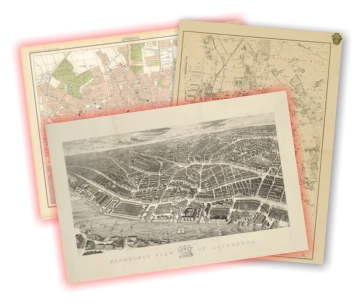
Allerton c.1900
Use the slider in the top left to change the transparency of the old map.
A Tidy Township
Allerton lies on the gentle slopes of a ridge that rises up from Garston. At the beginning of the 20th Century it still had a view overlooking the Mersey. The Victoria County History noted "An air of tidiness reigns over what remains of the natural features, with neatly-kept hedges and railed-in paddocks, and shrubs grown to rule and measure". The soil was good, and useful for growing anything from root vegetables to tree plantations.
Earliest Days on Merseyside
Although a handful of prehistoric objects are known from Liverpool, Allerton has both of the most spectacular ancient monuments in the city: the Calderstones and Robin Hood's Stone. Little is known about these monuments. Robin Hood's Stone is most likely a Bronze Age standing stone (perhaps even part of the Calderstones). The Calderstones themselves are the remains of a Neolithic or Bronze Age burial chamber.
These monuments, lying close together, were part of a larger prehistoric landscape. A Bronze Age cemetery once existed in Wavertree, and in Allerton itself the Pikeloo Hill and Rodgerstone are two more ancient monuments which have vanished from the landscape.
Merchant Palaces
As the VCH suggested, Allerton was an attractive area for those wealthy enough to live here.
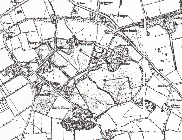
The 1st Edition OS map shows a scatter of farms and small houses (e.g. Booker's Cottages, Beech Farm, Calder Cottage, Vale Cottages, Fletcher's Farm - now Fletcher's Barn). Larger homes include The Hall, Calderstones, Quarry Bank, Hay Hill, Greenhill and Allerton Hall. This map also shows the house known simply as 'Allerton', built right in the centre of the township, between Dowse House and Allerton Priory.
Allerton Hall is perhaps the most significant of the large houses in the area. It was owned in it's time by two very different men. William Roscoe, famed abolitionist, moved in during 1799. Later, Richard Wright, a cotton trader, flew the Confederate Flag from Allerton Hall during his time there.
Streets of Allerton
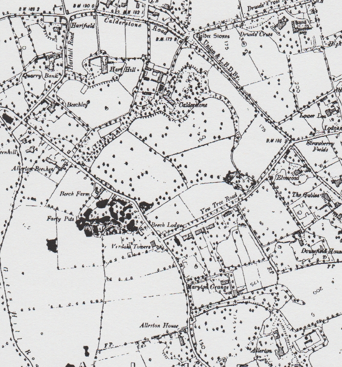
The other main feature on the 1850 map is Allerton Road, winding north to south down the centre of the township. Folly Vale Lane (later Menlove Avenue and Vale Road) runs to the east, between Allerton and Woolton. Greenhill Road (later Mather Avenue) runs to the west, next to Garston. It crosses under the Edge Hill and Garston branch of the London and North Western Railway at Allerton Station (now Liverpool South Parkway).
The building of these merchants' palaces continued to the end of the century; the 1891 edition shows the appearance of Strawberry Field and Allerton Tower.
The merchants' wealth depended on the increase in trade and industry as part of the industrial revolution. The railways were expanding, and Speke Junction (where the London and North Western Railway met the Cheshire Lines Railway) grew to include Allerton Engine Shed and a group of new sidings (now all part of Allerton Traction Maintenance Depot).
Allerton's Parklands
Liverpool Corporation bought the area now known as Calderstones Park in 1902 from Henry & Charles MacIver, who had owned it since 1875. It is first marked as a park on the 1904 map, with the Allerton Oak shown within its boundaries.
The house known as 'Forty Pits' is shown opposite the junction of Allerton Road and Yew Tree Road. The area was wooded, and it was certainly an attractive cove of woodland and ponds until the 1970s. One of the ponds still exists behind the houses.
It is hard to know whether the pits were originally a quarry for sandstone or sand. It may have been a natural feature that the local house owner exploited to enhance his own lands.
Expanding the Suburbs
The pace of change increased as the 20th Century reached the half way point. Areas like West Derby, Childwall and Woolton transformed into semi-detached suburbia, but Allerton remained a very green place. The biggest change on the 1939 map is the creation of Mather Avenue, leading from the Greenhill Nursery to the housing estates of Garston.
Other changes show the city encroaching: Short Butts Farm is now surrounded by Allerton Cemetery. Menlove Avenue grew from the widened and straightened Folly Vale Road. That now snakes off to the north just before it reaches Mendips, a kind of fossil of the former road.
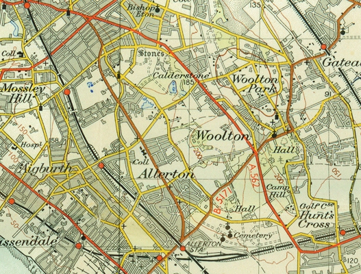
By 1947 the edge of built-up Liverpool sits on the north boundary of the old township. By 1952 the metropolis had all but encompassed the parklands.
Hunt's Cross
This is an area adjacent to Allerton, and paired with it as the Allerton and Hunts Cross city council ward. There is a cross in the centre of the suburb. Tradition says that the Liverpool Hunt used to meet in this area, but there was an area of land, now part of Liverpool John Lennon Airport, called Hunt's Tenement (shown on a map of 1855). A closer link may be found here.
Allerton as a suburb
Since the late 20th Century little has changed in Allerton. It is this feeling of history which gives Allerton its distinctive character. Although no remnants of the 'natural' landscape have survived, a huge proportion of the area has never been built on. The parks allow all of today's Liverpudlians to enjoy something only the wealthiest could before they gave their estates to the city.
Bibliography
- https://web.archive.org/web/20120205091629/http://www.mersey-gateway.org/pastliverpool/housing/mansions/mansions.htm - details of Forty Pits under Mansions, PASTLIVErpool, retrieved 23rd January 2010 (archived from the original at http://www.mersey-gateway.org/pastliverpool/housing/mansions/mansions.htm)
- Cowell, R., 2008, The Calderstones: a prehistoric tomb in Liverpool, Merseyside Archaeological Society, Liverpool.
- Farrer, W., & Brownbill, J., 1907, 'Townships: Allerton', A History of the County of Lancaster: Volume 3, pp. 128-131.
Mapping the history of Liverpool
Old maps, interactive maps and the historic landscape of Merseyside.
Buy maps
Many of the maps on this site can be bought as high quality prints, either as paper or ready-framed.
You can also buy notebooks, postcards, greetings cards and other map-printed items!
Go to the shop to find out more
The book
Liverpool: a landscape history is a book about Liverpool and Merseyside from the very earliest days to the 21st century.
You’ll learn about everything from the Calderstones to the Capital of Culture.
Signed copies are available direct from me, the author, in the shop.
#ads

A set of three matching Cassini maps from three different periods, designed to appeal to anyone who wants to discover the hidden history of their local landscape.
- Cassini Old Series Maps first published between 1805 and 1874
- Cassini Revised New Series Maps first published between 1896 and 1904
- Cassini Popular Edition Maps first published between 1919 and 1926
Leave a comment
Francis Kenny
09/30/2012 18:01:41
Do you have any information on Gladstone Hall, next to John Lennon's house?
Thanks,
Francis
Reply to Francis Kenny
Martin Greaney
10/14/2012 12:24:17
Do you mean the University Halls of Residence? This was established as a school - the Gladstone Mission Hall - in the 19th century, by the Gladstone Family who owned property in the area.
Martin
Reply to Martin Greaney
Julie Chapman
12/30/2012 23:14:50
Many thanks
Julie Chapman
Reply to Julie Chapman
Martin Greaney
01/26/2013 20:18:22
The only extra information I've been able to find that might be of interest is a Notice in The London Gazette for 1904 (PDF) regarding the death of Margaret Ashcroft, 'late of Short Butts Farm'. It's just asking that anyone who thinks they have a stake in her Will to get in touch!
The farm was very near the railway, which meant that Brunt Lane had to be diverted when the line was laid. This is mentioned (along with Short Butts Farm) in another London Gazette, from 1876 (PDF). That helps to date the railway a little more closely! If John Cumming Jephson was an engineer, perhaps he had a close working relationship with the railway and the sidings which once existed in this area of Garston.
Regards,
Martin
Reply to Martin Greaney
Nick Ashcroft
10/03/2016 20:56:36
Reply to Nick Ashcroft
Julie Chapman
02/04/2021 15:31:17
I am really sorry but I have only just come across your message!
By all means contact me via my email address. I have also researched the Ashcroft side of the family on Ancestry.
Kind regards
Julie
Reply to Julie Chapman
Nick Ashcroft
09/09/2025 22:54:34
Reply to Nick Ashcroft
Peta O'Connor
11/06/2013 11:54:41
Peta
Reply to Peta O'Connor
John Richards
09/07/2015 04:35:16
Reply to John Richards
Martin Greaney
09/09/2015 21:01:11
Thanks so much for all that information! I'm trying to build this site into an encyclopaedia of such knowledge, so that's a great start! I might get around to putting it on the History Map.
If anyone else has any information like this, please feel free to contribute!
Thanks again,
Martin
Reply to Martin Greaney
Matt Evans
09/05/2016 10:34:44
Reply to Matt Evans
john paul
09/05/2016 19:05:33
Fully agree with you mate as do so many of the locals. It is imperative with so little time to submit objections that as many people or even a committee submit their opposition to this plan asap. Please keep me in the loop regarding the support for refusing this application. Are you aware that the application is actually for a FOUR STORY block not a 3 story as can be seen from the plans but not the application text!
Reply to john paul
john paul
09/05/2016 19:10:59
Reply to john paul
paul .s.brown
01/21/2017 20:08:08
Reply to paul .s.brown
Janet Hughes
03/19/2017 16:35:33
Reply to Janet Hughes
Nick Ashcroft
09/09/2025 22:56:57
Reply to Nick Ashcroft
Grace
11/26/2017 03:00:17
Reply to Grace
Martin
12/05/2017 16:07:38
I've not been able to find much about Allerton Hall in the 1500s. The manor was owned by the Lathom family, one of the large and important families in this part of Lancashire. The current hall wasn't built until about 1736, though there would have been earlier halls on the same site. By that time the estate had already changed hands, to Richard Percival at first, and then John and James Hardman. It was under the Hardman's ownership that the Hall was built.
Regards,
Martin
Reply to Martin
Rob Jones
05/02/2018 13:15:07
Reply to Rob Jones
Martin
06/19/2018 18:41:46
Reply to Martin
T O'Rourke
06/11/2018 11:48:09
Reply to T O'Rourke
Martin
06/20/2018 22:06:42
There's not much to say about those allotments, except that they've been allotments for quite a while! They're marked as such on the 1927 map, and apart from the encroachment of houses around the edges, have changed very little in the mean time!
Best wishes,
Martin
Reply to Martin
Lorna Hampton-Bowes
11/05/2018 12:38:51
Reply to Lorna Hampton-Bowes
Martin
11/06/2018 21:51:50
What an exciting project! I've put out your message to my social media followers so hopefully someone will have something to hand. I don't have many photos to hand but if I find something I'll be sure to be in touch!
Martin
Reply to Martin
Allie
01/20/2019 18:36:21
We have a conveyancer report from 1954 still referencing the gatehouse as 'Rockfields' but not much else.
Thanks very much,
Allie
Reply to Allie
Martin
02/04/2019 13:11:46
I'm afraid I can't be of much help with details, but I can see from the old maps that Rockfield, the large house, still existed up until at least the 1961 Ordnance Survey map. Therefore there might be records (detailed plans, maybe photographs) in the local Liverpool Record Office.
Martin
Reply to Martin
Berni Bailes
11/28/2020 17:57:27
Is that the corner of Cinder Lane and Cromptons Lane??
We lived in CL from 1965
Let me know
Reply to Berni Bailes
Allie
12/02/2023 22:48:09
Sorry I just saw your comment when I was checking something else!
No we're further towards Menlove AVE then Cinder Lane but I walk down that street often.
Sorry for the 3 year gap in reply!
Reply to Allie
Nancy Lindsay
02/02/2019 01:05:33
Reply to Nancy Lindsay
Martin
02/04/2019 14:14:19
I'm afraid I can't find out much about the land at Allerton Priory, though there are a couple of snippets about the owners when it was built, and just before: http://wooltonvillageuk.tripod.com/allerton_priory.htm
Best wishes,
Martin
Reply to Martin
John Jones
06/02/2022 16:38:19
Have you, or can you point me in the direction of, any information regardiing West Allerton raiilway station. I am coming up very soon to do a video on the lest used stations in Merseyside, but cannot find any information about West Allerton.
Many thanks
John
Reply to John Jones
Martin Greaney
06/17/2022 11:46:49
A very interesting website project you have! I'm not having much luck finding out any historical information apart from what's on the West Allerton Railway Station Wikipedia article. It looks like it's always been a minor station, close to others.
Best wishes,
Martin
Reply to Martin Greaney
Nick T
08/26/2022 23:53:29
Are The Good Old Days
Nick T
Reply to Nick T
Amanda Jane Donaldson
08/29/2023 09:41:59
Wm W was a few things in his occupations, in 1881 he was a retired farm baliff he was age 78 at that time, in Woolton Road. He had a son Thomas age 33 in in 1871, he was an Ag labourer there.
Reply to Amanda Jane Donaldson
John. Hussey
12/02/2023 19:28:44
Many thanks John Hussey
Reply to John. Hussey
David crosbie
07/20/2024 20:16:03
Do you have any information about springwood cottages on brocklebank Rd?. My great grandparents lived there in around 1890's and my great grandmother died there in 1896.
Many thanks
Mr David Crosbie.
Reply to David crosbie
Emma N
08/08/2024 13:21:24
Reply to Emma N
Martin Greaney
08/27/2024 17:00:05
Here's a map showing Booker's Cottages (1830s-1880s): https://maps.nls.uk/geo/explore/#zoom=16.6&lat=53.37044&lon=-2.90477&layers=257&b=1&o=100
Best wishes,
Martin
Reply to Martin Greaney
Danny
12/23/2024 13:55:14
obviously written by something who has never visited or lived in the area .
Mather Avenue for example does not go anywhere near a Garston council estate.
Robin hood stone is a considerable distance from Calderstones Park.
Most of the places mentioned either border Allerton or outside of Allerton.
fourty pits was never open to the public.
It was built on early 70s.
Not much real.detail about the large private estates or the owners such as Lord Brocklebank Baronetcy, of Springwood in the County Palatine of Lancaster.
Also part of Allerton.
Reply to Danny
Martin Greaney
01/01/2025 12:24:40
Thanks for your concerns about my accuracy, but I think you're worrying unnecessarily, as you've misread the article in parts (and possibly missed the photo of Allerton Towers, which I took myself, on a visit! ;) ). I'll admit that some wording could be ambiguous, so to clear up some things for the benefits of future visitors to this page:
So, of course, not every history website will include everything that every visitor thinks should be included. Therefore I just put in what I find interesting.
I hope that clears things up.
Best wishes,
Martin
Reply to Martin Greaney