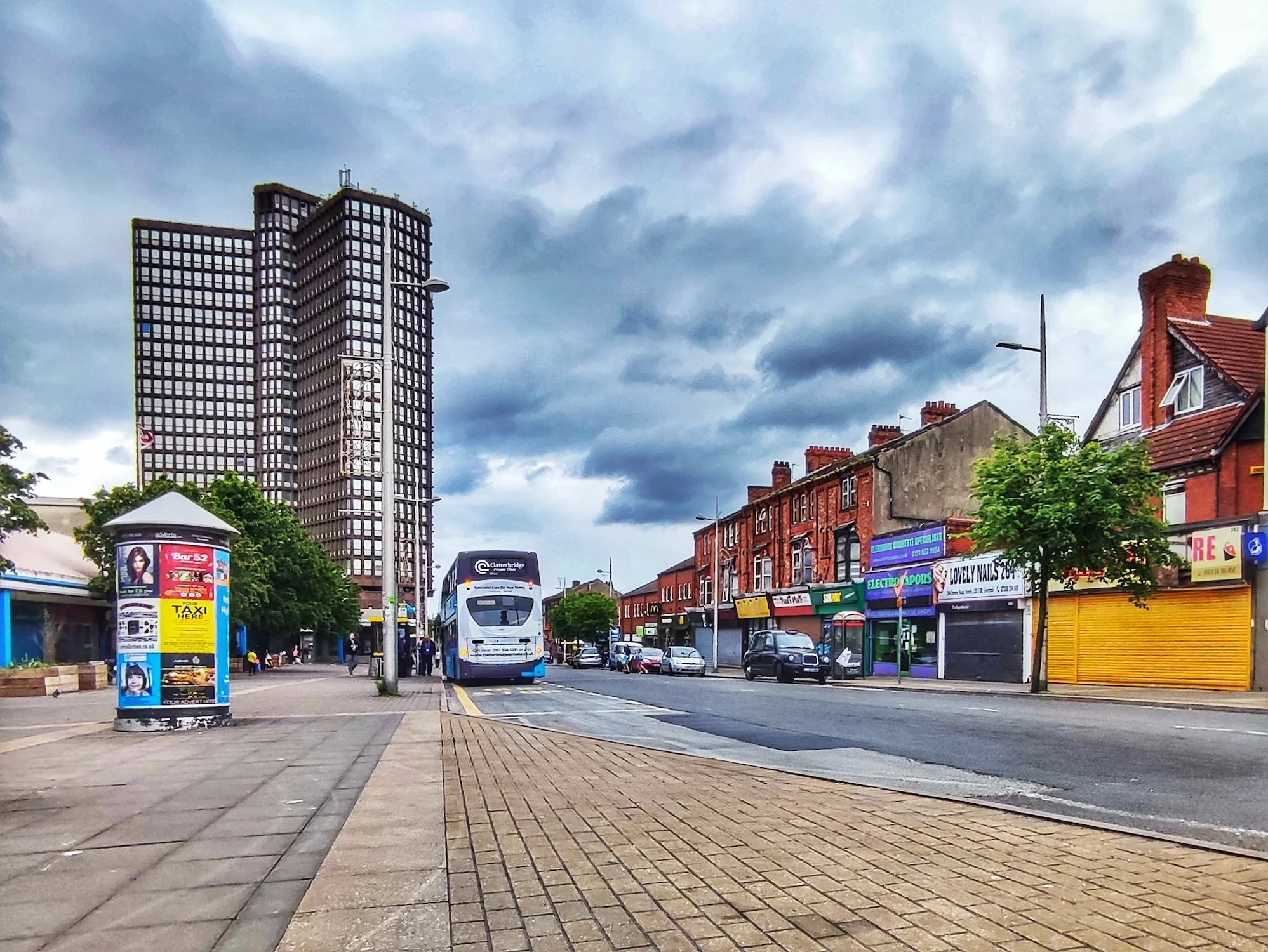
Bootle began its history as a large, well-defined village completely physically separate from Liverpool. But as the city expanded, Bootle found itself well-placed during the expansion in the Industrial Revolution. It soon bulged with incoming labourers, using the tram and railway to get to work at the docks. The area became packed with industrial buildings of all types.
In this article
- The Seaside Resort
- The Railways Arrive; Bootle Explodes
- Pitch, Tar, Carbonic Acid and Parks: Bootle in 1910
- The hospital, the suburbs and schools: Bootle on the verge of World War Two
- The railways contract, but Bootle goes on: the 20th Century
Soon, like other ‘lost villages’, Bootle was swallowed up in the expanding metropolis. Traces of the original hamlet can still be picked out today, and the town remains administratively part of Sefton, rather than Merseyside.
Recommended sources
Website: https://aintreevillageparishcouncil.gov.uk/the-parish/parish-history/ The Bootle Times website seems to be a hive of activity. There are dozens of oral history recordings and an active forum where you can discuss all Bootle topics from history to wanted ads.
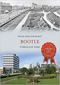
Book: Bootle Though Time, by Hugh Hollinghurst. If you’re interested in the before-and-after style of books then this is the edition which covers Bootle. Luckily, there’s plenty of text too, so you’re not starved for historical information.
Bootle c.1900
Use the slider in the top left to change the transparency of the old map.
The Seaside Resort
The original village of Bootle sat at the junction of Merton Road and Litherland Road. The location is just over a mile from the River Mersey, and Bootle became known as a seaside resort, with Merton Road leading down the hill to the sea.
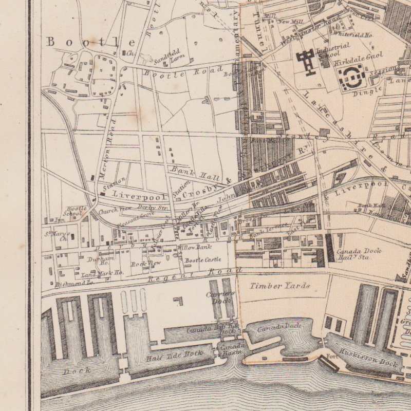
This map is taken from a detailed one from the Illustrated Globe Encyclopedia printed in 1878.
In 1878 (and also visible on the First Edition Ordnance Survey map of the area) the village of Bootle sits alone to the north of Liverpool. The docks to the west have stretched this far north, but Bootle’s strong links with the port were still a little way in the future.
What’s certainly visible on the map are the new roads being laid out connecting Bootle with the city, and the railways which sweep in from the north. These fed Liverpool with cargo and new citizens and workers, so that by soon enough the city would grow and engulf its small neighbour much like it would the other villages on its periphery: West Derby, Walton, Garston, Childwall etc.
Bootle was, by the turn of the 20th century, a densely populated area, with roads forming the classic gridiron pattern which characterised much inner city suburbs across the country. Its closeness to the docks made it an attractive place to live for those workers too poor to afford to commute other than on foot. The railways and the Leeds-Liverpool canal which snaked through Bootle brought work in their own right. Bootle was almost an industrial centre itself.
What had once been considered an airy seaside town with good links to the beach changed under the pressure of Liverpool’s thirst for industry and commerce.
Towards the middle of the 19th Century, however, Bootle was already starting to see the effects of the expansion of Liverpool to the south.
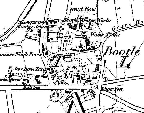
The 1851 Ordnance Survey First Edition shows Bootle clearly as still a separate village. It’s bounded by Merton Road, Bootle Road (now Hawthorne Road) and Litherland Road. There was no north bounding street (where today there is Waterworks Street), but Bootle Water Works was already in existence by this point.
The start of industry
Bootle’s future as a centre for industry was already being mapped out. The Bootle Chemical Works sat north of the village centre and the Leeds Liverpool Canal skirted the west. The Liverpool, Crosby and Southport Railway and the Liverpool, Blackburn and Accrington Line of the Lancashire and Yorkshire Railway passed on either side.
However, at this early stage in history these great transport links seem to ignore Bootle. Instead they drive towards the more important centre of Liverpool itself.
The docks would also grow to be a major part of Bootle’s future. But in 1851 only a few docks stretched this far north of Liverpool. Instead there was a thick strip of waterside buildings from Liverpool Road (now Seaforth Road) down to Bankfield Street in Kirkdale. These houses stand in rows, and included hotels and pubs.
Bootle Castle sat just north of the northernmost dock (Canada Half Tide Dock), and a church dedicated to St Mary can be seen in what is now the cemetery at Church Gardens. Bootle School was another civic building in the area.
Roads in existence in the mid-19th Century show that great plans were afoot for Bootle. A large area south of the village had already been laid out by 1851, with a handful of roads named after Oxford colleges. In addition to Merton there was Wadham Place and Balliol Road (joined by others later). This arrangement of roads without buildings is a tell-tale sign that planners saw potential for this area to grow in the coming years.
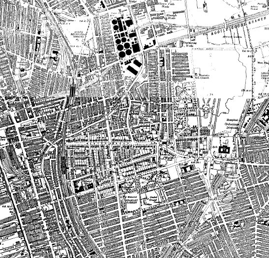
The Railways Arrive; Bootle Explodes

By the end of the 19th Century Bootle is in the midst of a huge phase of expansion, perhaps more than most other outlying parts of Liverpool at this time. The village itself had already been swallowed by the hungry city, although it remained close to the edge of the countryside.
The areas north and south of Balliol Road had been filled with houses by now. Buildings associated with the influx of people were springing up all over the place: Balliol Road Baths, various chapels and recreation grounds, and a football and cricket pitch on Hawthorne Road (now South Park) were just some of the facilities the growing suburb needed. The Northern Recreation Ground first appears on a map in 1894; this later became North Park. The new Liverpool Parochial Cemetery was located in Bootle township, relfecting the more sobering aspects of life in Victorian Liverpool.
Industry was expanding. A rope works opened near West Derby Workhouse. Railways criss-crossed The whole landscape. The Liverpool and Bury Railway extended to Fazakerley in 1867, and the Lancashire and Yorkshire Railway added the Bootle branch and the Seaforth Connecting Line. This was connected to the Liverpool, Blackburn and Accrington Line to the south of Bootle. All these railways branched off into the goods stations lining the docks. The area formerly filled with riverside houses and pubs was now dominated by industrial buildings – branch lines, goods depots and warehouses.
Bootle docklands
The docklands were ever-changing and expanding. Canada Dock had grown and become Brocklebank Dock, and Alexandra Dock and Langton Dock were the latest northern expansions. Liverpool’s famous Overhead Railway was extended to Bootle (Seaforth Sands Station) in April 1894 (http://en.wikipedia.org/wiki/Seaforth_Sands_railway_station).
West Derby workhouse had been completed in 1869. This was the second building by that name, and served the northern part of West Derby Union (http://www.workhouses.org.uk/index.html?WestDerby/WestDerby.shtml). Parts of this building still survive within Walton Hospital, which now occupies the site.
As well as the main areas of Bootle becoming a part of the city of Liverpool, Litherland, the formerly separate village to the north, was becoming built up by 1894. This was becoming a town popular with prosperous businessmen who wanted to escape the smoky, dirty city. The area was handy for the train and tram systems, and yet was semi-rural in feel. As the map shows, houses here were semi-detached but large, with big gardens separating them from their neighbours. This was a common house type for the upper middle classes in the Victorian period in Liverpool, and the pattern is also found in Allerton, West Derby and on the Wirral.
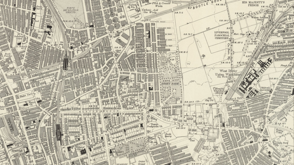
Pitch, Tar, Carbonic Acid and Parks: Bootle in 1910
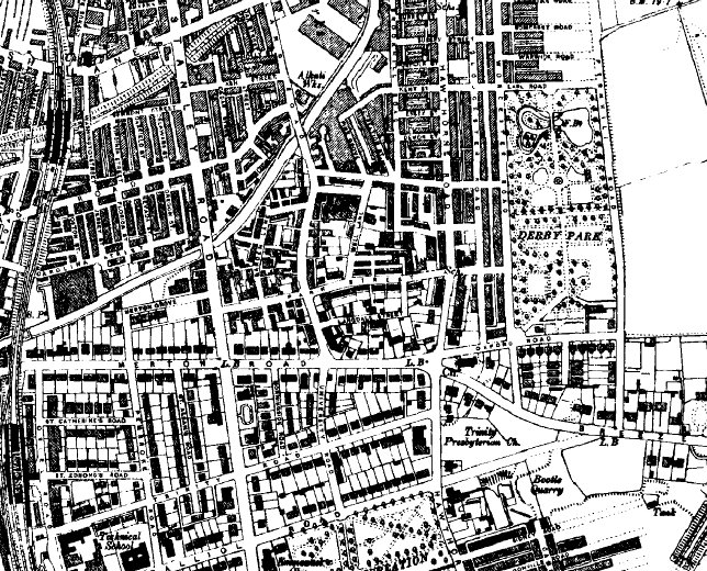
The next available map in the OS series was published not long after the 2nd Edition of 1894, but the landscape is constantly evolving.
Land to the east of the original village, which in 1894 looked like it might be laid out for housing had by now turned into Derby Park.
Bootle industry now included a pitch and tar works, a smelting works, a carbonic acid gas works, Bootle Foundary, and a wire rope works.
New roads hint at Bootle’s aspirations: Hertford and Exeter Roads share their names with Oxford colleges. Shakespearian characters inhabit other streets: Othello, Juliet, Macbeth and Romeo all have roads named after them. These names are still there, although the roads have changed shape over the years.
The hospital, the suburbs and schools: Bootle on the verge of World War Two
The Ordnance Survey produced another maps of Lancashire just before the Second World War.
This new edition shows Hillside High School Bootle Girls Grammar school. This later merged with Balliol County Secondary School, with the current building opening in 1987. (Thanks to Pete for giving me this information in his comment below.)
The Grammar school building replaced a handful of large houses, including Breeze Hill House. This house had given its name to the road which ran east-west to the south of it, and the road still bears its name.
The number of houses in the area kept growing, with Orrell Park expanding up to the edge of the Bootle Goods Branch of the London, Midland and Scottish Railway. The West Derby Union Workhouse had now become Walton Hospital.
Industry was still expanding. The wire rope factory seen on the previous map was changing with the times, becoming the Electric Cable Works. A tar distillation works had appeared on the site of the carbonic acid gas works, and tar distillery had opened towards Linacre on Hawthorne Road. Neighbours of this included a rubber works, two tanneries, a lead works and a cooperage. Today this area is still a mass of warehouses, lorry depots and small factories.
The railways contract, but Bootle goes on: the 20th Century
By the middle of the 20th Century Bootle had settled into the form it is today. What began as the Aintree Sorting Siding had grown into a massive spider’s web of rail on the boundary between the two townships. But the culling of the railways was in full swing by this point. The 1978 map shows that many had already been abandoned, and were probably becoming overgrown by this time. Even today, some stretches through Bootle and Walton remain green tracks. The bridge over the modern Merseyrail track just north of Lynwood Road is part of one such section which lies just behind the everyday facade of north Liverpool.
Jeremy Woods
I like your history of Bootle, a place which I have not visited yet! I obtained a copy of a painting for my late father, of Alexander Dock – Bootle during the Second World War. His escort group were shown coming back from an Atlantic patrol.
Nicolas Monsarrat says in his book “Three Corvettes” –
“It was curious to think that a large part of the Battle of the Atlantic was fought from this small corner: that if you wiped out this dock and what it had done since the war started, the answer might be a starving Britain.”
Perhaps Bootle history is a little understated!
Susan Jackson
It was kept secret on purpose by Winston Churchill ‘s government during the war.
They did not want the British people to know if the Battle of the Atlantic was lost we would starve.
90 % plus approx of the housing stock in Bootle was affected by the bombs. Know one knows it was the most heavily bombed area of WW2, Inc London, Coventry and Dresden.
The Queen has attended Bootle Town Hall to commemorate this but it is still cancel culture.
It is to this day a very poor and deprived area.
Thank you Bootle for you’re unacknowledged beyond the call of duty action during WW2 .
William Michael Roberts
Hi Susan, as an apprentice and later tradesman, I worked at Campbell and Isherwoods, Penpol Works on Hawthorne Road, which was demolished around 5 years ago and new housing has sprouted. We worked in the workshop and on ships berthed in most of the Liverpool docks. I have just retired after almost 50 years working but it was C& I that gave me my start. Many thanks to those old hands who had the patience to train me. I in turn have trained others and realise now, how lucky I was. My father took me on a tour in Exchange Flags and pointed out WW II bullet, bomb and shrapnel damage, which is still evident to this day!.
Beverly Taylor (nee Cooper)
Interesting to note William Roberts. I started my work journey at Campbell & Isherwood. I was a secretary there to one of the Engineers. I was only just out of Business College then. One of my main duties at the time was to type up the Switchboard Specifications. The office I worked in was near the Drawing Offices there. I still have my original references from them too.
Paul Newton
Spot on. My Mum and Dad were born in Bootle, and after they came back from Hong Kong (where I was born) they settled there. I’ve lived there ever since, in the shadow of Johnson’s Dye Works, and I’m fiercely proud of my Bootle roots, and the fact that it isn’t a part of Liverpool, but a town in its own right.
Martin
Hi Jeremy,
I think all parts of Liverpool have a hidden part to play in the city’s history, and Bootle, being close to the docks, is certainly no exception! Glad you found the article interesting, and thanks for sharing the quote.
Martin
Angie
Thank you Martin
I found this Web page searching for dockers life, merchant navy, looking for information doing my family research I’ve found this very informative as most of my mums family where from bootle and it gives a clear understanding of working life throughout the years will be visiting this site often.
VERONICA OLSON (DELANEY) NOW USA
I was born in Bootle 38 emery street , i lived in Berry Street when the war was on , my brothers were evacuated to Wales, i had to stay , i remember running over the Coffee House Bridge during the time bombs were dropping going fron shelter to shelter . Our house got a direct hit with me in the celler, the neighbors helped dig me out. i remeber our house got robbed , when we went to a shelter one night, when we got back the next morning the house was compleley empty the even took the nail that held the curtains up. I went to st winifreds school.my mam was pregnant at the time the war was going on ,.our house was on the corner behind a butcher shop, when it got hit i remember smelling the meat cooking it was hanging and was on fire. I dont want my grandchildren to go thru a war like i did, to say that kids forget is bull, i remember every thing about it.i have been in the Staes for 50 years but still a british subject,i go home every once in a while, but i get lost it has changed sooooo much i like the old Liverpool
Martin
Hi Veronica, thanks for your comments. It’s sounds like what you went through during the war was pretty terrifying. You don’t often hear stories about looting of houses – it’s all Blitz Spirit and stiff upper lips, but they must have been hard times.
Yes, Liverpool’s changed a great deal. That’s part of the reason why I set up Historic Liverpool and Liverpool Landscapes, to document the changing landscape, and the losses to heritage. The old buildings help us connect to history, so that we remember the lessons of the past. I hope you find the sites interesting.
Regards,
Martin
Donna
My Dad- John McNicholas also went to St Winifride’s,and later St Martin’s. The family lived in Chapel St and were bombed out in the May blitz of 1941. I am looking into the history of Bootle around this time. My mother’s family were also from Bootle-Braesnose Rd, she went to St.Alexander’s school.
Libby Egerton (Bevan)
Hi Donna, how weird! I was just doing a bit of research into my dad’s family and saw your comment. My Mum was from Oberon St which was off St Johns Rd and she also went to St Alexanders. What year was your mum born? Mine was 1921.
Hope you’re keeping well, I’ll tell the girls I’ve chatted with you when we go out next. ( Maureen Owens, Hazel Byrom and Pat Lydiate!) x
Donald Muirhead
Hi I lived in number 3 Chapel Street 1946___53ish When I was young we played on waste land I supposed that must have been before being bombed
Richard Morison
Donald Muirhead. The bombing stopped in 1941 so the waste lands you played on would have been after the bombings ended. My grandmother lived in nereby Seaforth St and I spent my childhood years visiting her there on a daily basis.
Paula Jackson Smith
My late mum lived in Seaforth Street with her mum, dad and 6 sisters and one brother. The Cheshire family. All in theo ne tiny house ! We have a great many stories from their time there.
Karen
Wow what an intresting little read 🙂 i really enjoyed your little story then Thanks
lucie andersen
my family also lived in berry street: The Andersens / think they became the Murphys for a time. But must be before your time there. Sounds like you had a lucky escape from the cellar during the bombing. My other grandad ran the criddles treacle factory and he built merton village.
Shirley Porter
Hi would you know any of the porters who lived in Holywell street bootle early 1940s they had 11 children both Henry and Edith died between 1949 and 1951 leaving all 11 children?
Marvin
Hi – It was very interesting reading about your time in Bootle during WW2. How disgusting that you house was robbed during those time when everyone was supposed to stick together – no wonder you moved to the States. Yes, as few people will deny – old Liverpool was one of the most attractive cities with all it’s lovely Victorian character buildings, had these been maintained the region would be very popular with tourists. Unfortunately, some individual without any imagination decided to try to imitate Manchester – it never quite worked out. Liverpool is now a no-where mess with scant personality.
kath tunstall
I play bowls for Linacre Park Ladies team.Always wondered were Linacre Park was.I know LinacreLane, Road and Linacre Chapel but surmise that there must have been a park with a b
owling green for us to have inherited the team name.we played at the Crescent,Johnson Ave when I joined in 1985 so maybe it was near there.
Martin
Hi Kath,
I’ve not been able to find a reference to Linacre Park, although as you say there are a couple of roads around there with the name in.
The village of Linacre once stood on its own, where Linacre Lane and Stanley Road now join. There was a Linacre House near the junction, so it may be that Linacre Park was a colloquial name for the house and its grounds, even though it’s not marked on the map.
pat simpson
LINACRE PARK COULD BE THE BOWLING GREEN OPPOSITE jOHNSTON’S DYE WORKS.
The ground used to be a nursing home first until around the late 80’s? then the Bowling Green was build on field still used as it is today, 2014′
Both nursing home and bowling green would need an address, so could it be Linacre Park you are looking for for Kath? pat
David
The road along side the bowling green is called Lathom Road L20 5EL
I used to live there.
Trish Bennett
To my knowledge Linacre Park was Is also known as North Park which is at the bottom of Linacre Lane where the 3 Banks were, well the Park was on the 4th corner lol.
Cally
think anybody interested in bootle should have a look at this group on facebook …. it’s called Bootle past and present
Cally
apologies…group actually called Bootle Past
Martin
Thanks for the recommendation, Cally, Sorry, the link seems to have been truncated in your link. The full one is: http://www.facebook.com/pages/bootle-past/117688741593604
Vivian Jamieson
Hi, found your link on Bootle Past, really interesting read. I was born and brought up in 81 Park Street (now a medical centre I think). My brother lived in Strand House so use to visit quite a bit and the area has changed so much over the years. Quite like wandering around Liverpool city centre with the great buildings and trying to remember what it was like when I was a teenager in the 60’s going out there.
Jim Dolce
Did you live near to Willie Magee? I lived in Lambs Terrace off Litherland Road less than half a mile from you! What was your maiden name?
Patricia Molloy née Morgan
My grandmother lived in Garden Lane her name was Doris Harley my sister and I used to visit her every Friday
Linda Gregory
Hi, can you remember the name of the factory that was on Park St, circa 1965. My mum worked there, she talked about coming home smelling of eggs or with fingers/hands cut from slicing meat of carcasses. Thanks
frank sheridan
Hi martin, i was born in camble st “,bottom of strand rd” can you or any of your readers remember the name of the fella that used to cut hair in his back yard?
I have fond memories of my dad takin me and my brother when we were little kids,
on the corner of irlam&strand road, or there abouts .
thanks
ps, i am now 50
so were talkin about
40yr ago
Martin
Hi Frank,
I’ve posted a link to your question on the Historic Liverpool Facebook page (https://www.facebook.com/pages/Historic-Liverpool/232165420148779) to see if anyone else there remembers the back yard barber.
Regards,
Martin
c wells
chap who used to cut hair in his back yard and in his celler when it rained jim connolly dont know if i spellt his surname right
William Stafford
Yep that’s the man, use to love going there. Down the entry down the wide sandstone steps to where he cut your hair, as you said when it rained you go inside to get your haircut, all mixed dining chairs to sit on. He was a tall thin man with white hair and a really nice man to.
Started going to Jim’s about 1960 went there for years
patricia cunningham
yes jim conelly i used to go there with my brothers
walter banks
His name was Jim Connolly,In the early fifties he was the only barber who give you something different from a short back and sides.
Jim Brown
Hi Martin I tried contacting Frank Sheridan, I think I know Frank if its the same guy with a sister named “Rose”. Tried contacting Frank with the link from this site but the link is not working.
I can also remember the guy who cut our hair in his back yard…. was his name “Joe Sinnott”
Martin Greaney
Hi Jim,
Yes, that link’s not right. It might have meant to be http://www.bootlehistory.com/bootle-past.htm. They have a forum on that website, and a contact page here: http://www.bootlehistory.com/bootle-contact.htm. Maybe you’ll have some luck contacting him there.
Regards,
Martin
c wells
read your article on bootle bootle is not part of liverpool post office tried to put cistencliverpool on the postal address many years a go but bootle council objected and the post office could only put L20 on the postal address bootle was in existence many years before liverpool being mentioned in the doomsday book
Martin Greaney
Thanks for your comment. Well, these things happen often all over the country, and there are always arguments about whether a certain town should be part of its larger neighbour or not. Landscape archaeology is not as concerned with boundaries as local councils can be, and Bootle, as you say, has an ancient and very important contribution to the history of Liverpool, so I’m including it here. Hopefully in the future I’ll be including more areas outside Liverpool, but which have an influence – I mention Kirkby several times already, though it’s not strictly in Liverpool. Thanks again for commenting.
Martin
Peter B. Young
As CWells has stated Bootle has never been a “part of Liverpool”. Bootle had it’s own Police Force, until the 1970’s when they merged to become Liverpool & Bootle Constabulary (later Merseyside Police), & Fire Service (again later merging to become Merseyside). These mergers were both political & economic decisions made at the time of merger. Bootle was also awarded County Borough status in it’s own right in 1889, which stood until the creation of Sefton County Council, again a political bandying about in the 1970’s. Prior to these political machinations Bootle thrived as a proud and independent township. It’s only real connection, or association, with Liverpool was when the Post Office rationalised itself and introduced the fore-runner to Post Codes and labelled Bootle as Postal District L20, having made Liverpool Copperass Hill sorting office the main sorting office for the whole region.
DAVID OWENS
HI THEIRMYNAME IS DAVIDOWENS AND IUSETOGO TOSTPAULS SCHOOL IN BOOTLE SOME GOOD MEMORIES AS WELL FROM THE OLD BOOTLE STRAND SHOPPINGCENTRE
Bill Foster
Hi David
I went to St Paul’s from about 1951 to 1956.
I was little and skinny with curly ginger hair.
Maybe we were there at the same time.
R Banks
Ask the majority of people from Bootle where they are from, and they will say Liverpool, and we wouldn’t have i
t any other way!
Russ Wood
“Bootle! Where de fleas fly backwards and de bugs wur clogs!”
Karen Williams
Hi Veronica, I read your post with interest as my Mum lived in Berry street during the war, until they Had to move to Sidney road due to the street being too badly damaged. Her name was Kathleen Davies and she about 5 when the war started, she had two older sisters Delia and Mary and a brother Tommy, her mother was Catherine. You probably don’t know them, still it’s nice to share your wartime memories, especially knowing that my Mum’s experience would have been very much the same. Kind regards from England :O) Karen x
Kevin Bonnesen
Hi Karen, I was wondering if you are related to the Mrs Davies I knew as a youngster who lived at No 30 Sidney Road,I lived at No 28 Sidney and the Mrs Davies I knew did have a daughter called Delia who I believe lives by Johnsons Dye Works.
Thank you.
Kevin.
Mary Davies
HI Kevin, just read your post, I’m Karen’s cousin and our gran did live at No 30 Sidney Road. Delia did live by Johnsons but died several tears ago, my mum is Mary, I must ask her if she remembers you. Do you remember the Warings at no 34 I think. The boys name was Denis?
Regards
Mary
olive stevenson
hi my father lived at 24 sidney road hes lived in ireland for over 50 years now
Denise Edwards
Whilst researching my family tree, I have come to this very informative web site. My father and his siblings where all born in Exeter Rd, Bootle, in the early 1900s. The family name was Finnegan, my father being Thomas (Tom). I am trying to find out when properties 68 – 76 Exeter Rd, Bootle 20 where built, does anybody out there know? These properties have recently been demolished I am very sad to say, as they held such very happy memories for us as a family. If anybody can offer any information it would be very much appreciated.
Martin Greaney
Hi Denise,
The houses you’re interested in were built in the early 1900s, and the 1908 Edition of the Ordnance Survey map shows half the road having been built with the other half still to come. So we can date those houses pretty closely.
Hope this helps with your research.
Regards,
Martin
Denise Edwards
Many thanks Martin, still gathering information on the Family history
Mary Davies
Would be interested in any pictures of Berry Street Bootle before the war, my mum lived there as a child and is living there in her memory now. Would be nice to show her some photos of how it was.
Thanks
Martin Greaney
Hi Mary,
Well, I must admit I’m having trouble finding photos of this street, even though the area in general was quite well photographed!
Anyone else able to help?
Martin
Mary Davies
Thanks for looking.
Peter B. Young
Try Bootle Times – Past & Present
http://www.bootlehistory.co.uk/forum/index.php
Kevin Bonnesen
Hi Mary,My mum moved to Sidney rd after her house was bombed during the blitz,She lived in Coleridge st next to the timber yard and it all took a hit ,When she moved to Sidney rd her name was kathleen fairclough her sister was patricia and was living with her grand-parents,Even after getting married she stayed at the house until december 1968 then we moved to summers avenue,My mum had four of us little darlings I will put them in order of birth-David-Kevin-Stephen-Pauline, I was speaking to my mum a while back and she said she bumped into Delia and went to see your nan with her, But she cannot remember when, But did remember it was by johnsons, I remember your nan well she was a lovely lady who always said hello,My mum said she liked to be called KITTY, Yes i do remember Dennis Waring -In the hot days of the 6Os he had a wooden barrel in his back yard which he would fill with water and jump in and keep cool,Those were the days! Hope to hear from you soon.regards Kevin
Adam Cree
I have an enquiry that perhaps someone can make some suggestions on. I am researching a woman of some importancer to Chorley in Lancashire who was brought up in Bootle – Olive Street but also other streets.
I wold like to trace her education. I have a pretty strong hunch that she was taught by the Sisters of the Sacret Heart of Mary in Bootle.
I have found elsewhere that the order sent sisters from Beziers in France to Bootle (and some Irish sisters. A school on Marsh Lane was set up through the pasrish priest of St James’.
Is the current All Saints’ School the vestige of this foundation?
Did Bootle have other schools run by the order (apparently ther were some in Liverpool.)
The website of the order records this at http://www.rshm-nep.org/page-10015-beginnings.html and the American site expands on this same detail at htp://www.rshm.org/History/England_1872 but there are no easy local contacts. There is a photograph at this web site which is unatributed ans if anyone knows its origins I would be interested.
faith through her actions. I have research her and the memorial books extensively and a gallery is about to open in our local museum. There are still many gaps in her record and I am curious about the roots and expression of her faith – what drove her? I am also curious about her education and her links to Beziers. She may even have had an association with the Sisters of the Sacred Heart of Mary. Her half-sister was a Reverend Mother of the Order of the Holy Child Jesus.
If anyone could direct me to where records for this original school or previously published material might be found I would be very grateful.
Martin Greaney
Hi Adam,
I’ve not been able to find too much information on the school in Liverpool, although there is a school marked on the early (19th century) Ordnance Survey maps and a Roman Catholic church, both on Chesnut Grove where the current All Saints Primary School is (although across the road from the modern school building). Perhaps there is a link, although the website of the school does not have any historic information on it.
Sorry I couldn’t be more helpful, but good luck with your research.
Martin
pat simpson
Hi, Adam Martin.
The name of the school on corner of Marsh Lane and Chestnut Grove was named St James’ Roman Catholic Church, and School the same name which has now amalgamated with All Saints..
The infant and Junior school stood next to the Church and opposite, on corner of Marsh Lane and Chestnut Grove was the girls senior school.
The boys were next door and up the stairs over the girls class’ separated by a wall was the main entrance.
The church started off as a little hut hidden in a short street next to Chestnut Grove. The history of the church can be found by putting name of church and road into search. Pat
David
I came to live in back Oregon Street Bootle from Barry South Wales as a small baby boy of three weeks old in February 1944. At five years I went to St Marys School in Irlam Road, then Balliol Road Secondary School until fifteen years. I worked as a butcher boy, on the timber, made toffee, worked in a tin foundry. 1964 Strand Road and surrounding streets were demolished to make way for the New Strand to be built. Life was never the same after that, our whole way of life was gone. Now, today, most of Bootle has been demolished and our live and memories of people who we once played with and loved are all gone. I only found two of my school mates after 1964. I would love to know what happened to all my mates I used to play with as kids in Oregon street in those early years.
Martin Greaney
Hi David,
That’s a fascinating story – you must have been a part of much of Liverpool’s classic industries! It’s such a shame that communities were broken up and the houses demolished. It happened all over Liverpool and beyond, and life is never the same afterwards. I bet many people would love to go back to a life where communities were tight-knit and familiar.
Thanks so much for your contribution here.
Regards,
Martin
peter farley
hi mate peter farley here i lived in Oreon Street number 16 next to the Matthews i am still mates with Johnie Jones AKA Babba what number was your house cheers
Ian Holmes
Bootle has great community in it, is full of history right back to 1086 it was in dooms day book, we are indpendent of Liverpool we just have trade relationship with them like USA an UK so yer my granddad worked at docks an my famliy may have come here in 1086 when Bootle was created so any questions as me i answerthem best as possible enjoy reading.
Martin Greaney
Hi Ian,
Good to hear the community of Bootle is still going strong! As you say it’s always been a strong trading place, and was considered a ‘coastal’ town when a road led down to the beach before the docks were built. I’ll let people know you can answer some of their questions!
Regards,
Martin
Ian Hankin
Great read about Bootle martin, have brought my mother back for her 80th from NZ and are staying at Breeze guest House in the old village. Our family lived in klondyke and orrell and some still do. My great gran lived 2 doors along from the Albion pub and went for a pint there last night. Thanks for filling some gaps. Does anybody know where I could get a copy of Images of Bootle and Orrell? The author sadly passed away a few years ago I believe.
Martin Greaney
Hi Ian,
Thanks for getting in touch – must be great to bring an ex-pat back to the home city! You can get hold of Images of Bootle and Orrell on Amazon. It’s a shame the author is no longer with us; he seems to have been quite prolific in the Liverpool/Bootle history genre!
Regards,
Martin
Peter B. Young
Try Bootle Times – Past & Present
http://www.bootlehistory.co.uk/forum/index.php
Adrian. R. Hankin
Hello Ian .my Granddad. George Hankin lived at 4 Worcester road Bootle they had a family of 13, do you think we are related
PHIL RYAN
I lived in 100 st, Johns rd Bootle in 60s ,gess who lived next door ( Mike Pender ) of the group the searchers
mick mcbride
hi I sat next to mick Prendergast at school we went to st winifrides also in our class was chris crummy who became the drummer with the searchers & johnny McNally lived at 108 st johns road kirkdale
Sue read ( nee Murphy)
i lived in 31 St. John’s road and the McNally family lived next door to us at number 29. Alice and frank McNally were John’s mum and dad, and I think their other sons were called frank and Brian. I used to listen to Johnny mc and Mike pender practicing in the parlour, Alice would sometimes let me in to watch them. Great childhood memories. I think one of my aunties used to date Mike pender, I remember him hanging around my grandmas house in syren street waiting for my auntie to come out.
Ron Schofield
Hi do you remember the Schofield,s who lived at 45 St Johns Road
ronnie
my gran lived in 47 st johns road her name was spriggs
David Rees
Do you remember the old lady who lived at no. 14 she had a dog called Queenie ?
Bill Foster
I went to St Paul’s C of E primary that was between Brasenose Road and St John’s Road.
There were mini-wars between the kids of St Pauls and St Alexander’s….Catty-dogs v Proddy-dogs, we said.
I had ginger hair, and often found myself rolling around with another ginger kid from St Alexander’s.
Later found out he was John McNally.
Tony Short
Hi, Iread your post about Chris Crummy living in 108 St Johns Road when I was searching for info on that address. My parents had a house on that site that was destroyed in the May Blitz of 1941, in fact 75 years ago yesterday! We were thankfully in a shelter under Stanley Hospital but came out to total destruction of 108.
I went down St Johns Road yesterday on its anniversary but all there is now is an industrial park. Whatever happened to Ivor Stree were my relatives, the Kelly’s lived?
Martin
Hi Tony,
I’ve read that Ivor Street was a very small street between St Johns and Brasenose Streets, so I assume that when the area was redevloped with industry in the late 20th century it was simply built over. A lot of streets in Liverpool disappeared in this period when redevelopment happened.
Martin
David Rees
Hey Phil I know this might sound stupid but do you remember an old lady who lived at 14 St. John’s road bootle ? She had a dog ” Queenie ” who talked . I lived in Tillard st kirkdale , this is not a wind up , as it happens We used to see Mike Pender all them years ago going to St. John’s church fountains rd on a Sunday . I’ve been laughed at for years for telling people about Queenie she could say ” St. John’s road ” and ” down town ” I now live in Wakefield west Yorks I AM NOT MAD , honest . If you’ve never heard of Queenie I don’t blame you for thinking I am regards Dave
Keith Moulsdale.
I lived on garden lane in the prefab on the corner of Lambs terrace from 1945 1953. my best mate was Jimmy Clark who lived on lambs terrace I am trying to contact Jimmy Clark
Keith Moulsdale.
Thank you please,leave any reply ata my email.
David Stone
My maternal grandfather David Edenfield McCracken OBE (born I think in 1860s, died in 1936) was for many years Chief Traffic Manager of the Liverpool Docks.
I would be very interested to learn any more about him and the working of the docks in the late 19th/early20th centuries.
Martin Greaney
Hi David,
While I’m not much of an expert on family history, I can humbly suggest my own book which has a section on Liverpool’s docks and their development. Also, the Merseyside Maritime Museum has a great selection of archives (photos and videos) on the topic.
Mark McGrady
Hi is it possible to find any info r.e proctors timber yard which was on corner of strand road,Bootle,by fire bobby station…I’m trying to trace the connollys who worked there? Or more importantly William McGrady who worked there? Thanks
Martin Greaney
Hi Mark,
As my expertise extends to maps rather than family history, I can show you a map of the area from the late 19th century: . Hope this is of interest, and if you’d like a different era or scale let me know.
Martin
Margaret Macdonald
hi i am trying to find out about a robinsons foundry that was i think on seaforth rd it was a smelting plant, and my late husband did his apprenticeship there
John Hayden
Did you find out what you wanted to know about Robinson’s foundry?
It was
A Robinson & Co Ltd.
Knowsley Road Bootle.
The Foundry was in Akenside Street Bootle, just down the road from Robinson’s works and main office building on the corner of Knowsley Road. T
his was opposite the Winefred Hotel (now called the Gateway Hotel)
Reg wallis
Margaret,you are partly right, Robinsons/engineers / was at the junction by the seaforth sands overhead railway and of course the Liverpool corpy bus terminus / trams. I passed this many times on the way to British American Tobacco in Bootle
Helen Howard
Hello you have not given your late husbands name, my husband Les did his apprenticeship at Robinsons in the 60’s. He may have know him.
Paul Towns
Bootle is a horrible dump, were the residents claim to be from Liverpool. It is no moore part of Liverpool than Freshfields is. That is why the road signs say Liverpool on them when directing you towards Liverpool. Yet in Liverpool they say city centre!
Davey
Ay Paul, you may be right, but from where I come from, Bottle is no different to the surrounding areas of Kirkdale, Walton, Anfield, Everton, Scotty Road…do you want me to go on???
You see, you’ve just shown what a two-bob snob you are as all these areas are probably within no further distance than 2-3 miles apart with many of them adjacent to each other.
That doesn’t bother me though, as I’m proud that I’m from Bootle and Merseyside, and I’m proud that I border the City which I love, but before you post your snide remarks from your little hamlet in Mossley Hill (or wherever you’re from), think about many of the people you’ve insulted from YOUR city of Liverpool.
There’s absolutely no difference in the people.
We’re all proud mongrels and descendants of different cultures and races and that’s what makes us what we are.
Some though, forget where they do come from with this arrogance and snobbery.
Get me?
Ann burgess
I lived in bootle and had found memories of it,the people were very educated,and would help anybody,humane is the word,l loved liverpool as well.l hope to visit soon,god bless to all.
Martin
Hi Ann,
Thanks for your comment. It’s so great to hear you have happy memories of Bootle. I’ve never lived in such a friendly city!
Martin
Peter B. Young
Sadly I think that the point bring made was nothing to do with snobbery. The places that you mention (Walton, Everton, etc.) were all originally their own townships that did get swallowed up by Liverpool as it expanded. Bootle, however, did not become part of Liverpool and remained it’s own township until the creation of Sefton County Borough in 1974.
Trish Bennett
I know this post is 8 years old but I have just read it for the first time and would like to say….BRAVO….I couldn’t of said it better
to be honest I probably would have been really nasty lol so I commend you on your Post …
My husband lived in 63 Southey Street and I have never met a horrible person ever.
They are the Salt of the earth.xxx
Heather
Hi, I’ve just seen this post. Do you happen to know when the current houses in Southey Street were built, please? I know they’re pre-war. Thanks.
Libby Egerton (Bevan)
I have just been given a copy of my Great Uncle’s certificate of his death. He was only 20 when killed in France in 1917 in 1st war. His name was Frank Clarke Bevan and his name is engraved on the War Memorial in King’s Park. The certificate shows his mother and father’s address as 2 Breeze Hill Bootle. Does anyone know if that address still exists? Thank you
kevin bonnesen
2 Breeze Hill has long gone and new buildings now stand there, If you have google earth you can look around yourself if you like, Its is opposite the church were the property once stood, Hope this is of help to you, Kevin.
shirley greene
im interested of anyone who lived around the sausage factory in literland in and around 1923 onwards, my family history goes back to my great grandmother who lived by the sausage works around 1923 when my father was born until her death in 1933, her name was lillian martha ann levey, she was previously married to a jack finchett, so she would of been lillian finchett, never knew her as she died in 1933 of stomach cancer and my dad and his sister doreen and his brother eric were all sent into work houses, if anyone has any information i would be over the moon, her husband was thomas levey, her father was harry onslow and her mother was mary onslow, or tabitha (not quite sure), on my mothers side , my mother was mary campbell, she had a sister patricia, they were brought up in dryden street in bootle, around 1935 until her marriage to my dad harry levey in 1951, anyone have any information no matter how small i would be so pleased to hear, intrigued to know anything, many thanks, shirley
Flo Hemmings,(nee) Valentine
Hello Shirley, I lived in 11 Dryden St,from 1941/1960,and although I was several years younger than your Mum I remember her and your grandmother most.I can`t tell you much only that they were always friendly and had time to chat to a kid playing in the street (me).I have in front of me this moment a card sent to me on the occasion of my marriage in 1960.It`s signed Mrs M Campbell,so I assume her name was also Mary.
Ann Pritchard
Please contact me, Uncle Harry was my Dad’s half brother. He spent a lot of time in our home in Maghull along with Eric. I loved him, he looked like my Dads twin. Doreen came to visit my Dad in Canada in 1986 . They hadn’t seen each since Lillian’s death .i have “goosebumps ” just writing this. Ann
Ann Pritchard
Another connection Shirley, my Mothers sister Sophie Pritchard worked at the sausage factory ( I believe it was called Richmond) and she became a really good friend of your Mom.
Ann pritchard
Did you get my reply, Shirley?
shirley greene
anyone know of the anderson family from bootle area, more so i am particularly interessted in a Jimmy anderson? or his family, i know little of him apart from i am told he was a taxi driver i think around the 60s and 70s, i know he had sisters , not sure where in bootle , any information on the family or jimmy inparticular please let me know, many thanks, shirley
My names maureen colton
My great grandmother was called sarah anderson from bootle maried martin colton
mick mcbride
I have an old map that shows church st &seaforth st but inbetween is bostock street can any tell me when it became kirk st I lived at 38 from 1946 till they wre pulled down in the fifties
WILLIAM Davies
Hi, What a great easy to use site with interesting facts and comments. I am not a native of Bootle being brought up in Huyton 1942-1956. My elder sister married a wonderful Bootle man and had a long and happy marriage. Sadly he died some 9 years ago and is badly missed. Being much younger than him I was always interested in his stories of Bootle him being born there in the parish of St. Winifreds. His name was Christopher Wilde born 1923, served in the merchant navy from the age of 14 years and was involved in the Atlantic Convoys finishing up as a chef. He sailed with Elder Dempsters and Bibby’s amongst others and swallowed the anchor about 1960.
As a surprise for my sister and his only daughter I thought I would like to compile a family history for them having done my side of the family.
Chris’s father was Nicholas Wilde, his mother Winifred Connoly, his grandfather lawrence Wilde, born Lough Shinney, Ireland. Winifred’s sister Margaret, married a ” Kelly ” their children being Chris’s cousins, now I think are all deceased but their children, Chris’s 2ndcousins may still be in Bootle.
It would be wonderful if anyone knows of the family of Wilde’s, Connoly and Kelly and could pass on any memories.
Thank You, Bill Davies
Pat Allerton
Hi Bill , I stumbled across your message somehow and it was the name Chris Wilde that at first caught my eye ( Not the ‘ Kelly ‘ reference , I think that may be purely coincidental as I do not know of any siblings of my father Teddy Kelly.. sorry ) But my mother was May Hickey b.1929 and they lived in Huyton until she married my dad Ted Kelly and they moved to Bootle in the 1950’s . My Mum used to speak of her times in Huyton and mentioned often a Christie Wilde. He may have been a year or two older than her because her brother my Uncle Jim ( Hickey b. 1926) told of having a street fight with Christie Wilde when they lived in Huyton . I know .. a bit of a ramble but just thought I should at least let you know . Best regards and good luck in your search .
Pat Allerton ( nee Kelly)
Cheryl Kitney
I think this may be my dad, Chris always known by the family as Christie! Born in Bootle 1924, think lived in Fitzhenry or Fitzwillism St, before moving to Huyton
Very close to his cousins i think-jimmy kelly
ALAN KILLEN
Have just stumbled onto this web-site and seeing the last (latest) entry as being July 14, it prompts me to post the name THOMAS FRANCIS NEIL as being of one of Bootle’s greatest WW2 heroes … one of “THE FEW” … and still living. On that very date (two days ago) he celebrated his 95th birthday just a few days after being a guest of The Queen at Buckingham Palace to watch the flypast of Spitfires/Hurricanes/Typhoons celebrating the 75th Anniversary of The Battle of Britain.
He is now W/Cdr T.F NEIL, DFC&Bar, AFC, AE who lived in 110 Downing Road and attended Bedford Road Primary & Bootle Grammar Schools until an enforced family move to Manchester in 1934. This was brought about by the promotion of his father who at the time was in charge of Bankhall Locomotive Shed on Stanley Road.
Shortly after leaving school, Tom joined the Volunteer Reserve of the RAF and in April 1940 was posted to the newly-formed 249 Sqn flying Spitfires (initially) until a few weeks later when it became a Hurricane squadron. It was in this aircraft that Tom (known as “Ginger” on the Squadron) would be credited with 14 enemy aircraft destroyed in the skies of 1940 England and 1941 Malta.
I had the good fortune to spend some time with him last Sunday and can assure you he is “as bright as a button” apart from his “undercarriage” which is somewhat the worse for wear these days and would benefit from extensive lubrication. That will not stop him from walking the length of Westminster Abbey in September as one of the Battle of Britain veterans escorting the Roll of Honour to the High Altar.
Proud of his origin, he delights in letting it be known that he comes from Bootle … and I salute a true gentleman and one of its greatest sons …
indeed, One of “THE FEW”
Whilst not being Bootle-born myself, I do come from “just down the road” … The Flower Streets of Kirkdale … and attended Daisy Street School.
Martin Greaney
Dear Alan,
Thanks for sharing all this info about Thomas Neil. It’s great to hear that he’s still going strong, and I wish him all the best for his visit to Westminster Abbey!
Best wishes,
Martin
Jean Leigh
I was pupil at Daisy Street School from 1948 until I was 11 in 1954. I then went on to Queen Mary H. School. We lived in Chelmsford Street and it is true, everyone’s door was left open during the day and the children played in safety in the middle of the street. (Well hardly anyone had anything worth stealing, anyway) Love to hear from anyone who remembers my family else. I went To Queen Mary H School after Daisy Street School. My name was then Fairclough.
Reg wallis
Seaforth following the ww11 was partly still rural with a dairy and the odd cow or two owned by the Williams family,I remember his horse and cart and the milk urns it carried now and then and children from Seaforth Vale west. Bowlring park, 2 cinemas,the sorting office, banks,bakeries, the overhead railway,numerous shops and meccano just by the now scrapyard. Families close to me, Jennings, o’neil, Forster, henshaw, Breslin, carruthers and good friend George sands. Schools, St Thomas’s, Rawson road and Waterloo sec mod. The years 1950 – 1960
allan coggins
ive been told of a reunite at the mel inn can any body give me details regards allan coggins
Mark
Hi does anyone have tales from being in school during the war please? Sounds feelings smells etc?thanks
Chris Briody
Only just discovered your site…Excellent read…Many thanks
My Dad, Chris, lived in Orlando Street in the ’20s and went to St Alexander’s
Although his surname was Briody, he thought his name was Brady until he started work ..aged 12/13!!
His Dad (also a Chris) died aged 43* when my Dad was 6 months old, leaving his wife, Annie (maiden name Holahan), with 3 kids to raise on her own.
Poverty was thereby a key feature of Dad’s upbringing and it took some time with him to establish why he had a strong aversion to my wearing jeans, as was the fashion of my time.
Apparently, the poor kids of Bootle were given ‘denims’ and clogs by the Council where needs demanded, but this marked-out the kids as ‘poor’…so they were stigmatised and probably picked-on accordingly.
He also told us that the denim was rough and untreated…and smelled something rotten!
Clearly, the inter-War period was a bad time for many families and those who came through a War or two, poverty and umpteen economic depressions fully deserve the respect of the modern generations.
Keep up the good work.
Regards
Chris
* Granddad Chris was a Ship’s Fireman for about 20 years…which was one of the dirtiest, unhealthiest jobs of the time…shoveling coal below decks. Mind you, he did have a stint as a Scaler…of Ships’ boilers…Luxury!!
Martin Greaney
Hi Chris,
Thanks for sharing that info. Yes, it sounds like the inter-war period was as bad as many of the more notorious times in Liverpool. I’m reading J. Callaghan’s Candles, Carts and Carbolic at the moment, which covers the period, and he mentions a similar thing with Council corduroy clothes – apparently the jackets could stand up on their own!
A fascinating period, especially as it’s so close to our own, really.
Martin
Nigel Smith
My grandfather as a very (very) young man was a boiler scaler’s timekeeper for a short while, for a firm based in Brasenose Road. Who knows – my granddad might possibly have been keeping check on the time to ensure that your granddad didn’t overstay the ‘safe’ period inside the boiler!
Chris Briody
Soz the address was Olivia Street not Orlando
Stanley Lynn
Hi just love all your stories about Bootle so interesting by any chance does any one have any memories of Marsh lane or knew my mums family they lived on marsh lane name was Thusingham she had 4 sisters she was the youngest age 87 now also trying to find out any information about a band that played in the area called the phil Hawes band 1940-1950s
Thanks x
Lee cox
Hi all has any one got any infomation on bedford road bootle just off queens road i was wondering if it was in the liverpool blitz one of my naboughrs says it was thanks
Martin Greaney
Hi Lee,
There’s a very useful map on the Liverpool Echo website showing where bombs fell on Liverpool during the Blitz. It shows that two bombs fell on Bedford Road, while a number of others fell on roads nearby. I don’t think the dots on the map are of pinpoint accuracy, but very close.
I can’t link direct to Bedford Road, but the map is quite easy to navigate, like Google Maps.
Martin
Joan Burgess (nee Green)
Hi,I remember Bedford Road, sorry my reply is totally personal just come across this site and I was wondering whatever happened to Hawthorne Road School, Orrell Rd School add Balliol Rd School I left UK in 1959 and attended all three.Now living in New Zealand since 1959. In touch with 4 girls still and visit when I can. Would love to hear from more girls from Orrell School or Balliol in particular. Hope they are all well and happy Joan.
Lesley Dean-Jones
My great aunt Ada left a note book of things she could remember about the family. One of them was that her grandfather, Robert Lawrenson, had married a Mary Bootle, one of the “Bootles of Bootle”. Does anybody know anything about this?
Martin
Hi Leslie,
The Bootles of Bootle were a family who can trace their presence in the Bootle region to before the foundation of Liverpool. There’s a good brief history on this page on Bootle Family History.
I hope this helps.
Martin
Ann burgess
The burgess family lived in balfour road and Salisbury road,their cousins were the Houghton, who owned a second hand shop in Marsh lane,also cousins to the Howard in balfour road,and friends of the mahons in balfour road.happy times,in bootle and lovely people
Judith Sweetman (nee Burnie)
Seeking information on George Edward Emerson who lived with my father (his cousin) and my grandparents Frank and Jessie Burnie at 12 Oxford Avenue in the mid 1920s. George becam a commercial artist. Frank Burnie was the son of Joeph Burnie who with John Bell established the company Bell and Burnie.
david dunham
I was a student at the College of Commerce, later the Polytechnic before becoming the John Moores University between 1970 and 1974 and had digs at 73 Southport Road Bootle in the home of Ted and Else Yacobe who were in their sixties then. As far as I know, they were born and bred in Bootle. Else told me had two homes completely destroyed in the Blitz. Ted had a sister, Winnie, who was a probation officer and good friend of the then MP, Simon Mahon. I drank regularly (perhaps too regularly!) in The Mons Hotel and was taken under the wing of the Threlfall family, Billy, his brother, Stan and Billy’s son, George as well as becoming friends with Henry Bradley, Billy Gavin, Billy Mercer,Davy Kelly, Jonny Foy and others whose names I cannot recall. I wonder if anyone remembers them? I have been back to Liverpool many times since but have not gone back to the Mons although I know it is still there. It was the best of times for me and even forty years on, I regard it as one of the happiest times of my life living among some of the finest people I have ever met.
Judith Sweetman (nee Burnie)
Following my earlier post in August, I now know George Emerson had a son called Rory, He would be about 73 now and may have emigrated, Any information on Rory Emerson would be appreciated.
David Smith
I and my family have strong connections with Williams’s Toffee factory in Waterworks St Bootle from 1904 to 1991. I also have some documents relating to the production, Directors, costs etc: Where could they be put as a record of Bootle industry?
Martin
Hi David,
That’s great that you have something of historical value. The main place for anything like that would be the Liverpool Record Office, but of course Bootle has many interested groups who might also like to see them. Details of the Liverpool Record Office can be found on the National Archives website: http://discovery.nationalarchives.gov.uk/details/a?_ref=138
Martin
Paul Gardner
my Mom was born in Blare(or Blair?)Grove Bootle in 1932.she would like to return but i cannot find it.does Blare Grove no longer exist and if so what is the name of the road that has replaced it.i would be grateful for any info. many thanks.
David Shepherd
Just doing a bit of family history and had an ancestor named Hogarth who lived at 20 Pembroke Road at the end of the Victorian era. He was employed as a Manager at a ‘Spirit Distillery’ for many years. Any ideas where this distillery might have been located?
Martin
Hi David,
I’ve had a quick browse of the 1893 map in that area and can’t immediately see a distillery nearby. However, there are some large houses at one end of Pembroke Road, so if your ancestor was a manager the workplace could have been a decent distance from home, commuting by tram being well within budget. That said, Bootle was quite industrial on its western edges, near the docks, at that time, so there’s a chance the distillery was there alongside saw mills, soap factories and the like.
Best wishes,
Martin
David Rees
Come on somebody must have heard of Queenie the talking dog from St John’s Road no. 14 or possibly 24
Maureen Colton
Do u mean quenie powell there my dads cousins
Alan
I went to st John’s infants school and there certainly was a talking dog that lived in a house near miller’s bridge. Going home from school we used to climb up the bridge and bunk over the wall onto balliol road. Remember the Schofield’s, Mcgings and the Shannan’s when they came back. It’s all different there now
Harold Scotson
My wife Violet scotson Nee jones lived in Bedford Rd bootle and went to Bootle Girls Grammar School during the war and was evacuated to Heriford.I believe a history of Bootle girls Grammar School has been published but is now out of print. I wonder if anyone could help me locate a copy
Dinah DAntoni
Hello,
Seeking information on Bootle College. I have just found my great-grandfather studied there. I have a prize he got for writing and drawing in 1897. The principal was a man named James Frank. I tried to look for any information on the college on line and I could not find anything. Any info would be appreciated.
Thank you
Martin
Dear Dinah,
If I’m correct, Bootle College became what is now known as Hugh Baird College, which is still in Bootle. It’s an amalgamation of Bootle Municipal Technical College and the Bootle College of Art, becoming the Bootle College for Further Education in 1968. Depending on the year your great-grandfather was there, could he have been at Bootle College of Art?
Martin
Sharon campbell
I am doing family history I still live in bootle my grear grandparents lived in 23 br asnose rd Jimmy jones and ann found great merrories of bootle still got found a long lost ancestor who lives in michigan usa her nan and grandad used to live in 14 anyone know Billys pawn shop on marsh lane
walter banks
Was known as Willys locally.Two gentlemen ran it.Willy ran the pawnshop side and his partner Harry looked after the shop.Willy dressed rough and ready and Harry dressed very smartly.A friend of mine worked part time there for a few months while waiting for his civil service exam results.When he passed he had to go to London to work and they rigged him out from head to toe.Suit,sports coat and slacks shoes plus all the bits and pieces.He never forgot their generosity.I was a typical kid those days,visiting twice a week,Monday dad’s suit and shoes would go in and Friday they would come out.
Lyn Cranham
Does anyone have information on the Catholic Repository Marsh Lane early 1900s. My great grandmother Annie Kelly ran it. She was left a young widow with 10 children. I know she lived in Florida street.
Brian Smith
David
I was born and grew up at 20 St John’s Rd
the owner of the “talking dog’ was Rosina Reynolds at #14 SJR. My dad thought she was gaga. I left for the USA in 1970
Joan Parakin
I found this site when looking unsuccessfully for Ellison Elston family history but found the comments very interesting.Iwas born on Hawthorne Rd but grew up in Walton My great grand parents John and Elizabeth Rogers had atobacconist/dairy(one cow!) on the corner of Chapel st in the early nineteen hundreds across the road from St Winefrides. My father grew up with them.He told me he got in trouble for stealing the cream from the customers milk bottles!His other grandma was called Mary Ellen Ellison or Elston and was a charge hand in the Nickle bag and sack company in Bootle I don’t know anything about her family..I went with my Dad shortly before he died in 1965 back to see where he had lived but. Every house he took me to had been bombed which upset him .I learned later that more than2000 people were killed in Bootle in the war .I have been in Canada since I was a young woman but still go back occasionally
Martin
Hi Joan,
Thanks for sharing the info on your family history. I hope it’s progressing well!
I can’t imagine what it must be like to see all your old homes having been destroyed. It must have been distressing.
Liverpool, and Bootle (with its closeness to the docks) was indeed a heavy casualty in the war.
Best wishes,
Martin
Peter B. Young
80% of houses in Bootle were damaged or destroyed during the May blitz during WW11. Lots more were demolished during the slum clearances of the 60s/70s.
susan fletcher
My mother was Eliza Russell, known as Lily. She lived in Seaforth Street and had brothers who were in the Russell Trio – Jimmy, Joe, Paddy. they used to play at the Banjo. Does anyone have more information on the Russell family.
Allan Smith
Hi Jimmy Russell was my uncle, married to my mums sister Tessie. Lived in Bianca St. and had four children, Jimmy,Tony,Marie and Brenda
Diane
My Grandad was Sammy Russell who was on the drums.
Trevor Allen
When did a robinson and co of knowsely road close, i did my apprenticeship as a toolmaker there ,then national service in the army,from 1960 to 1962 then got married and emigrated to Australia, trevor Allen, married to Dorothy nee davies
Martin
Hi Trevor,
I’ve not been able to find out when this closed. I did see what might be a useful resource for you: https://www.gracesguide.co.uk/Category:Town_-_Liverpool. Looking at the location today, the houses there look to be around 1980s, so that would be the latest it would have existed I would think (though I don’t know the exact location).
Best wishes,
Martin
Freddy HEADEY
“Frank Burnie was the son of Joeph Burnie who with John Bell established the company Bell and Burnie.”
Is that the shipbuilders?
I’ve seen one reference to them in a poem by Cicely Fox Smith “home for Christmas”(though typed “bell & bumie(mistaking r n for an m).
Has anyone seen other information about them? My googling only found this page!
Philip Blundell
i lived in bootle 24 berry street in 60s my dad was born in that house in 1916
Martin
Hi Freddy,
There’s a brief information page on Grace’s Guide, which is a website which I’ve only come across this year but has lots of information on Liverpool companies. https://www.gracesguide.co.uk/Bell_and_Burnie Looks like they were refrigeration (including marine) experts!
Martin
Freddy HEADEY
Thanks Martin.
~~~~~
I see the poem actually calls B&B a Clydeside shipbuilder – but that might just be the writer picking up the wrong info or “poetic licence”.
https://allpoetry.com/Home-For-Christmas–Old-Style
James Appleby
My Great Grandfather Joseph Caves was a retired policeman living in number 18 Berry Street in 1917. Trying to find any information on him or the family.
Richard Em
Someone has told me that the old St Winifreds Church that stood on Derby Rd Bootle, wasn’t always an RC church. They said it was originally built as a Presbytarian chapel. Can you tell me if that is true, please. Thanks in anticipation.
Danny Murphy
I found this extract on https://taking-stock.org.uk/building/bootle-st-winefride/
The St Winefride’s mission was established in 1895 and first occupied a former Methodist chapel in Derby Road.
The present church was built in 1956-7 from designs by R. Montgomery, to seat 525 people. The contractor was William Tomkinson & Sons and the original estimated cost was £75,000. Archbishop Godfrey laid the foundation stone on 19 May 1956, and the church was officially opened by Archbishop Heenan on 15 September 1957.
Regards,
Danny
CHRISTOPHER KILE
Hi What Street today is Lyons Street Bootle,England my 3 X great grandparents lived on that street !
they lived at 26 Lyons Street in 1880’s they raised my great great grandmother !
Pete
Hi, an excellent site, thanks for sharing all if this information. One small point. When explaining the 1938 map you refer to the appearance of Hillside High School. Surely that should be Bootle Girls Grammar School, which became Hillside in 1972.
Martin
Hi Pete,
Thanks for pointing that out. I had no idea it was two schools beforehand! That shows the limitations of doing these histories purely from maps. You don’t know what you don’t know!
I’ll update the article above. The building there now, I’ve also since discovered, was opened only in 1987: https://www.geograph.org.uk/photo/5090914
Martin
Bobby
Joe sinnit used to give the echo out to any lad who was old enough to sell them his office was on seafront road the top of arther street we used to go to the greyhound track to sell them
Frank use to sell them by the station outside Stuart and Thompson’s geting all the Dockers coming out of Gladstone docks
In rely to J BRown
Melanie Watt
Could you tell me anything about 235 Derby Road, Bootle in the 1840’s/50’s/early 1860’s? My husband’s great great grandfather, his great grandfather and grandmother, her older sister and husband and younger sister all lived there, according to the 1861 census (+ 3 small children) His grandfather was born in Liverpool in 1863, his two great Uncles having arrived in 1859/1860. The men in the house all were marine engineers and had moved down from Renfrewshire; GG grandfather and GG grandmother moved to Liverpool, we think, in the late 1840’s, his son followed in the 1850’s. We are trying to find out how they came to move to Liverpool and who they may have worked for, but first, I wanted to know what that area of Bootle was like at that time.
His great grandfather/great grandmother were married at the Scots Secession Church in 1858. I have not been able to find out where that was. Sometime in the 1860’s Great Grandfather and family moved to Bremerhaven, apparently to advance steam ship engineering.
We are very interested in the Liverpool connection and any insight re Derby Road and the church would be much appreciated. We hope to visit the Maritime Museum when we can.
Martin Greaney
Hi Melanie,
That part of Bootle was, and still is, right next to the docks. At the time you’re interested in, the area was a mixture of warehouses and residential streets. The residential streets were made up of small terraced houses. There were some, but not many, courts, and these were further north than 235 Derby Road. As your ancestors lived on the main road, it seems likely they lived in a terraced house. The ones I can see on the map all look like some of the larger houses in the area, albeit still terraces: https://maps.nls.uk/geo/explore/side-by-side/#zoom=18&lat=53.44257&lon=-2.99855&layers=168&right=BingHyb.
I hope this helps your research!
Best wishes,
Martin
Paula T Ewen
“I am searching for a man by the possible name of David Williams. He may have been born around 1925 to 1930 ish in the walton bootle or West Derby area. If no luck is found around these areas of Liverpool possibly Flintshire or other Wales areas. He may have been a missionary travelling around. He conceived a daughter around Nov 63 so would have been in the Liverpool area around this time. I was born 7th july 64 in walton hospital. My mother is Elizabeth Ellen Braithwaite.”
Catherine Ball
Hi,
I was brought up in the Poets streets of Marsh Lane.
My siblings and I attended the old St James School in the ‘70s. It was closed and demolished in the late 70s and we moved into the former girls school opposite. In the old school, I recall scary outdoor toilets and separate entrances with “boys” and “girls” carved into the stone above the doors. Infants classes were on the ground floor and juniors on first floor. There were lots of glass panels and parquet floor. Such a shame it was demolished.
We did have a couple of nuns teaching. Sister Marie was headmistress of the infant school and Sister Margaret was a junior teacher. I was never aware of which order they belonged to. I do remember that the priests at St James’ were Salesian brothers. Dean Winder, Canon Casey, Father Noonan and Father Kelly.
My parents married at St James’ Eric Morrison and Mary Turner. They attended St Winifreds in the 1950s and 60s.
My dads parents owned The Queens Arms on Derby road. Alec and Amy Morrison. I have many fond memories of staying there.
My mums family lived off Irlam Road in Church Street.
Catherine Ball
Re: Nuns at St James’ they might possibly have been for the order of the Sisters of Marie Auxiliatrice. I do recall visiting their convent in Bootle.
Jemma Joines
Hi Catherine,
I was at St James School up to 1972 then went to St Augustines School across the road for 1 year then immigrated to New Zealand with my family. I think I remember Father Noonan. I am trying to find photos of the schools but having trouble. My siblings and I have fond memories of Bootle especially 181 Hornby Road, the North Park and walking to school under the bridge and along Chesnut Grove. I also have to say that moving to NZ was one of the best things my parents (Walter & Freda Graves) could have done and our early upbringing in Bootle have given us a terrific sense of humour, tenacity and enthusiasm for life.
Jemma Joines (nee Graves)
Heather
Hi, do you happen to know when the poets’ streets were built, please? I know it’s pre-war. Thank you.
Irene Williams
Hi my name is Irene williams my maiden name was Robinson I was born in Walton hospital 1952 I lived in university Rd for a while then moved to Balliol rd I lived in a prefab 12 balliol rd there were just 2 prefabs I lived in the second one they were just before you got to the traffic lights at hawthorn re Rd faceing the park south park I think I left bootle when I was 12 and moved to Huyton with my mum and brother my mum and dad divorced don’t know if anybody would have known him Billy Robinson I have good memories and bad memories. Also my nan lived in Olivia Street Her name was Robinson I had a very best friend Doreen Cobley who lived in the big houses in Trinity rd I would love to here from anybody who remembers me.
Bill Foster
Hi
I was born ‘on the landing’ at 40a Brasenose Road, in Feb 1946.
I went to St Paul’s primary school, next door to St Paul’s church.
Being a C of E school, we had nany mini ‘wars’ with St Alexander’s, the RC school.
Probably because we both had ginger hair, I used to ‘fight’ with John McNally, later of The Searchers.
We had family in Siren St….the Smiths and the Fitzgibbons’s.
I remember Rixon’s little shop, and the shop on the corner of Glendower St.
Patrick Riley
Hello Bootlearians: Does anyone know where Monty’s Bar was in Chinatown? My dad mentioned it in a letter from WW II. Patrick Riley
Patrick Riley
Hello Bootlearians: Looking for the last name of the family from Cyprus who owned the Monte Carlo, 27 Orrell Lane in the 1970s. Patrick Riley
Terry Morgan
Hello all. It’s fascinating to read all these reminiscences of Bootle. I lived at 106 Hawthorne Road, in between Gonville and Sidney Roads, from 1944 until 1971. I worked at the Bootle Education Office at 53 Balliol Road after leaving school and have very happy memories of playing in the street (mainly Gonville Road) with all of the kids (there were hundreds of us just post-war!) Some of the names were John McCabe, Brian and Barbara Lee, Owen, Oonagh and Joan Garrigan, Brian Schofield, Eric Dodd, Freddy and Robert Cartwright, Bernard and Raymond Grindley, Vinny Scanlon, Michael and Angela Forsyth and John and Cathy Hayes. Apologies to any I missed. Brian Lee became Lee Eddy when he formed the Lee Eddy Five, and Cathy Hayes wrote some terrific plays before writing for Coronation Street. We even had a bona-fide pop star: Acker Bilk’s drummer lived in no. 38. I’d love to hear from anyone who remembers me and our kid, John Morgan.
Terri Kidman
Hello everyone, I’m reading all these amazing stories and wondered if anyone who lived on St John’s Road remembers the Gavins, Smiths, Snows or McCanns. I lived at No 35 directly opposite Mike Pender’s house and remember when I was about 6 or 7 being allowed in by his mum to listen to him play guitar. I remember thinking he was absolutely gorgeous! My gran married Johnny Smith but was originally a Gavin. Her brother – my great-uncle Jimmy – lived with us and his ex- wife and daughter lived next door in No 33. My great-aunt Cissie was married to Lunc (nickname) McCann and they lived in No 41. My great-aunt Maggie and husband Luke Snow lived further along on the opposite side just along from a coal yard owned by Charlie (?). I went to St Winfred’s Infant School – by the canal – from 1958 to 1960 then to St Winifred’s Juniors until we moved to in 1962. Does anyone remember the little shop on SJR run by Miss Hughes. My gran would send me over for 1/4 butter and 2 slices of bacon for my grandad’s lunch and the counter was too high so Miss Hughes would loom over and scare the bejeezus out of us kids. My brother Chris and I loved putting a penny in the bubble-gum machine on the wall outside the shop. We even tried foreign coins!
There was a little shop on the corner of Brazenose Road owned by Bob McGuiness and I’d have to go there for a bottle of Aunt Sally for my gran to scrub the front step. God, I didn’t realise that I would remember so many little things. I was really happy living in my gran’s house. Life was simple and she was my hero.
Mike
Sorry but Bootle has never been in the city of Liverpool. It was governed by Lancashire up until 1868. From 1868 to 1974 it was self governing. Since 1974 it has been governed by Sefton Council after it was placed in Merseyside. The author needs to do some research.
Paul Newton
I’ve read a few comments, and the synopsis, the latter which avoids (for some unearthly reason) the fact that Bootle is, and always has been a separate town, and NOT part of Liverpool!