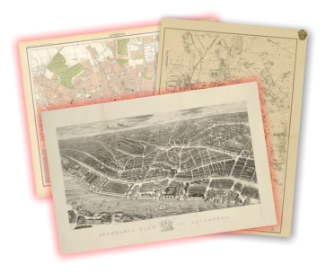
History of Bootle: a seaside resort, the docker's suburb, and industry
Bootle began its history as a large, well-defined village completely physically separate from Liverpool. But as the city expanded, Bootle found itself well-placed during the expansion in the Industrial Revolution. It soon bulged with incoming labourers, using the tram and railway to get to work at the docks. The area became packed with industrial buildings of all types.
- The Seaside Resort
- The Railways Arrive; Bootle Explodes
- Pitch, Tar, Carbonic Acid and Parks: Bootle in 1910
- The hospital, the suburbs and schools: Bootle on the verge of World War Two
- The railways contract, but Bootle goes on: the 20th Century
Soon, like other 'lost villages', Bootle was swallowed up in the expanding metropolis. Traces of the original hamlet can still be picked out today, and the town remains administratively part of Sefton, rather than Merseyside.
Recommended sources
Website: https://aintreevillageparishcouncil.gov.uk/the-parish/parish-history/ The Bootle Times website seems to be a hive of activity. There are dozens of oral history recordings and an active forum where you can discuss all Bootle topics from history to wanted ads.
Book: Bootle Though Time, by Hugh Hollinghurst. If you're interested in the before-and-after style of books then this is the edition which covers Bootle. Luckily, there's plenty of text too, so you're not starved for historical information.
Bootle c.1900
Use the slider in the top left to change the transparency of the old map.
The Seaside Resort
The original village of Bootle sat at the junction of Merton Road and Litherland Road. The location is just over a mile from the River Mersey, and Bootle became known as a seaside resort, with Merton Road leading down the hill to the sea.

This map is taken from a detailed one from the Illustrated Globe Encyclopedia printed in 1878.
In 1878 (and also visible on the First Edition Ordnance Survey map of the area) the village of Bootle sits alone to the north of Liverpool. The docks to the west have stretched this far north, but Bootle's strong links with the port were still a little way in the future.
What's certainly visible on the map are the new roads being laid out connecting Bootle with the city, and the railways which sweep in from the north. These fed Liverpool with cargo and new citizens and workers, so that by soon enough the city would grow and engulf its small neighbour much like it would the other villages on its periphery: West Derby, Walton, Garston, Childwall etc.
Bootle was, by the turn of the 20th century, a densely populated area, with roads forming the classic gridiron pattern which characterised much inner city suburbs across the country. Its closeness to the docks made it an attractive place to live for those workers too poor to afford to commute other than on foot. The railways and the Leeds-Liverpool canal which snaked through Bootle brought work in their own right. Bootle was almost an industrial centre itself.
What had once been considered an airy seaside town with good links to the beach changed under the pressure of Liverpool's thirst for industry and commerce.
Towards the middle of the 19th Century, however, Bootle was already starting to see the effects of the expansion of Liverpool to the south.
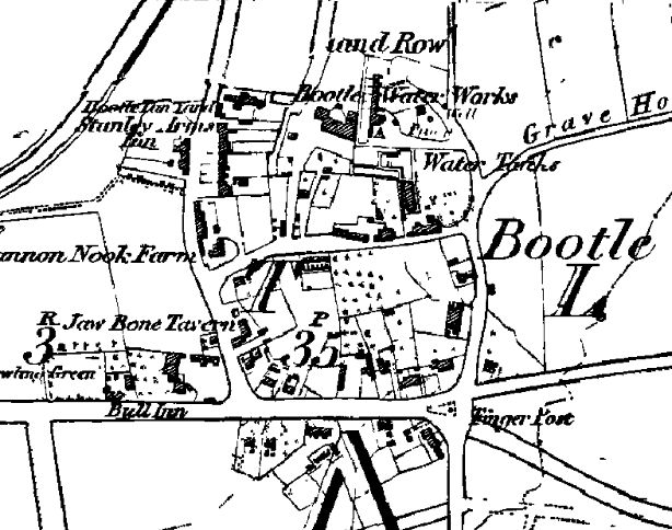
The 1851 Ordnance Survey First Edition shows Bootle clearly as still a separate village. It's bounded by Merton Road, Bootle Road (now Hawthorne Road) and Litherland Road. There was no north bounding street (where today there is Waterworks Street), but Bootle Water Works was already in existence by this point.
The start of industry
Bootle's future as a centre for industry was already being mapped out. The Bootle Chemical Works sat north of the village centre and the Leeds Liverpool Canal skirted the west. The Liverpool, Crosby and Southport Railway and the Liverpool, Blackburn and Accrington Line of the Lancashire and Yorkshire Railway passed on either side.
However, at this early stage in history these great transport links seem to ignore Bootle. Instead they drive towards the more important centre of Liverpool itself.
The docks would also grow to be a major part of Bootle's future. But in 1851 only a few docks stretched this far north of Liverpool. Instead there was a thick strip of waterside buildings from Liverpool Road (now Seaforth Road) down to Bankfield Street in Kirkdale. These houses stand in rows, and included hotels and pubs.
Bootle Castle sat just north of the northernmost dock (Canada Half Tide Dock), and a church dedicated to St Mary can be seen in what is now the cemetery at Church Gardens. Bootle School was another civic building in the area.
Roads in existence in the mid-19th Century show that great plans were afoot for Bootle. A large area south of the village had already been laid out by 1851, with a handful of roads named after Oxford colleges. In addition to Merton there was Wadham Place and Balliol Road (joined by others later). This arrangement of roads without buildings is a tell-tale sign that planners saw potential for this area to grow in the coming years.
The Railways Arrive; Bootle Explodes

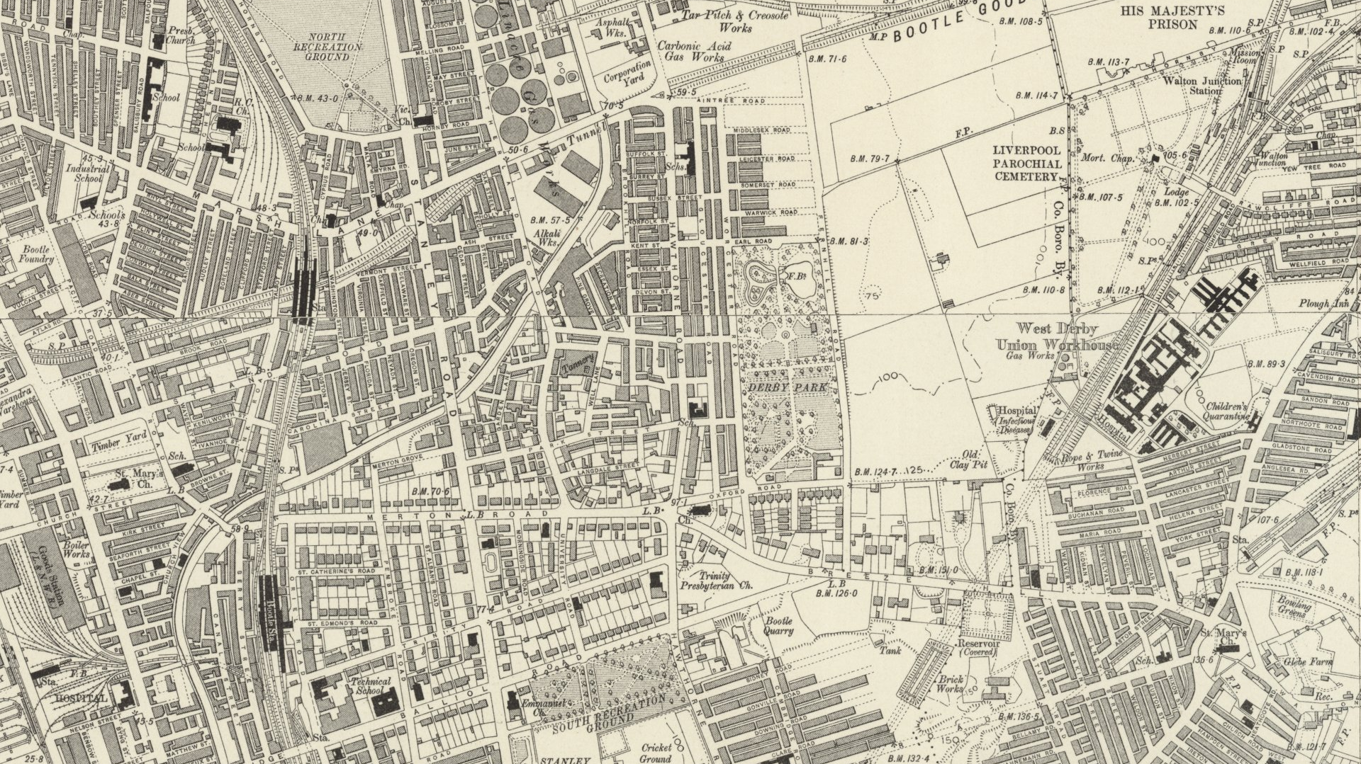
By the end of the 19th Century Bootle is in the midst of a huge phase of expansion, perhaps more than most other outlying parts of Liverpool at this time. The village itself had already been swallowed by the hungry city, although it remained close to the edge of the countryside.
The areas north and south of Balliol Road had been filled with houses by now. Buildings associated with the influx of people were springing up all over the place: Balliol Road Baths, various chapels and recreation grounds, and a football and cricket pitch on Hawthorne Road (now South Park) were just some of the facilities the growing suburb needed. The Northern Recreation Ground first appears on a map in 1894; this later became North Park. The new Liverpool Parochial Cemetery was located in Bootle township, relfecting the more sobering aspects of life in Victorian Liverpool.
Industry was expanding. A rope works opened near West Derby Workhouse. Railways criss-crossed The whole landscape. The Liverpool and Bury Railway extended to Fazakerley in 1867, and the Lancashire and Yorkshire Railway added the Bootle branch and the Seaforth Connecting Line. This was connected to the Liverpool, Blackburn and Accrington Line to the south of Bootle. All these railways branched off into the goods stations lining the docks. The area formerly filled with riverside houses and pubs was now dominated by industrial buildings - branch lines, goods depots and warehouses.
Bootle docklands
The docklands were ever-changing and expanding. Canada Dock had grown and become Brocklebank Dock, and Alexandra Dock and Langton Dock were the latest northern expansions. Liverpool's famous Overhead Railway was extended to Bootle (Seaforth Sands Station) in April 1894 (http://en.wikipedia.org/wiki/Seaforth_Sands_railway_station).
West Derby workhouse had been completed in 1869. This was the second building by that name, and served the northern part of West Derby Union (http://www.workhouses.org.uk/index.html?WestDerby/WestDerby.shtml). Parts of this building still survive within Walton Hospital, which now occupies the site.
As well as the main areas of Bootle becoming a part of the city of Liverpool, Litherland, the formerly separate village to the north, was becoming built up by 1894. This was becoming a town popular with prosperous businessmen who wanted to escape the smoky, dirty city. The area was handy for the train and tram systems, and yet was semi-rural in feel. As the map shows, houses here were semi-detached but large, with big gardens separating them from their neighbours. This was a common house type for the upper middle classes in the Victorian period in Liverpool, and the pattern is also found in Allerton, West Derby and on the Wirral.
Pitch, Tar, Carbonic Acid and Parks: Bootle in 1910
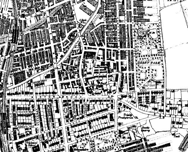
The next available map in the OS series was published not long after the 2nd Edition of 1894, but the landscape is constantly evolving.
Land to the east of the original village, which in 1894 looked like it might be laid out for housing had by now turned into Derby Park.
Bootle industry now included a pitch and tar works, a smelting works, a carbonic acid gas works, Bootle Foundary, and a wire rope works.
New roads hint at Bootle's aspirations: Hertford and Exeter Roads share their names with Oxford colleges. Shakespearian characters inhabit other streets: Othello, Juliet, Macbeth and Romeo all have roads named after them. These names are still there, although the roads have changed shape over the years.
The hospital, the suburbs and schools: Bootle on the verge of World War Two

The Ordnance Survey produced another maps of Lancashire just before the Second World War.
This new edition shows Hillside High School Bootle Girls Grammar school. This later merged with Balliol County Secondary School, with the current building opening in 1987. (Thanks to Pete for giving me this information in his comment below.)
The Grammar school building replaced a handful of large houses, including Breeze Hill House. This house had given its name to the road which ran east-west to the south of it, and the road still bears its name.
The number of houses in the area kept growing, with Orrell Park expanding up to the edge of the Bootle Goods Branch of the London, Midland and Scottish Railway. The West Derby Union Workhouse had now become Walton Hospital.
Industry was still expanding. The wire rope factory seen on the previous map was changing with the times, becoming the Electric Cable Works. A tar distillation works had appeared on the site of the carbonic acid gas works, and tar distillery had opened towards Linacre on Hawthorne Road. Neighbours of this included a rubber works, two tanneries, a lead works and a cooperage. Today this area is still a mass of warehouses, lorry depots and small factories.
The railways contract, but Bootle goes on: the 20th Century
By the middle of the 20th Century Bootle had settled into the form it is today. What began as the Aintree Sorting Siding had grown into a massive spider's web of rail on the boundary between the two townships. But the culling of the railways was in full swing by this point. The 1978 map shows that many had already been abandoned, and were probably becoming overgrown by this time. Even today, some stretches through Bootle and Walton remain green tracks. The bridge over the modern Merseyrail track just north of Lynwood Road is part of one such section which lies just behind the everyday facade of north Liverpool.
Mapping the history of Liverpool
Old maps, interactive maps and the historic landscape of Merseyside.
Buy maps
Many of the maps on this site can be bought as high quality prints, either as paper or ready-framed.
You can also buy notebooks, postcards, greetings cards and other map-printed items!
Go to the shop to find out more
The book
Liverpool: a landscape history is a book about Liverpool and Merseyside from the very earliest days to the 21st century.
You’ll learn about everything from the Calderstones to the Capital of Culture.
Signed copies are available direct from me, the author, in the shop.
#ads

A set of three matching Cassini maps from three different periods, designed to appeal to anyone who wants to discover the hidden history of their local landscape.
- Cassini Old Series Maps first published between 1805 and 1874
- Cassini Revised New Series Maps first published between 1896 and 1904
- Cassini Popular Edition Maps first published between 1919 and 1926
Leave a comment
Jeremy Woods
07/19/2011 14:11:59
Nicolas Monsarrat says in his book "Three Corvettes" -
"It was curious to think that a large part of the Battle of the Atlantic was fought from this small corner: that if you wiped out this dock and what it had done since the war started, the answer might be a starving Britain."
Perhaps Bootle history is a little understated!
Reply to Jeremy Woods
Susan Jackson
09/23/2021 03:15:27
They did not want the British people to know if the Battle of the Atlantic was lost we would starve.
90 % plus approx of the housing stock in Bootle was affected by the bombs. Know one knows it was the most heavily bombed area of WW2, Inc London, Coventry and Dresden.
The Queen has attended Bootle Town Hall to commemorate this but it is still cancel culture.
It is to this day a very poor and deprived area.
Thank you Bootle for you're unacknowledged beyond the call of duty action during WW2 .
Reply to Susan Jackson
William Michael Roberts
06/09/2022 19:11:38
Reply to William Michael Roberts
Beverly Taylor (nee Cooper)
10/30/2025 16:40:54
Reply to Beverly Taylor (nee Cooper)
Paul Newton
04/02/2025 23:29:50
Reply to Paul Newton
Martin
07/28/2011 12:36:40
I think all parts of Liverpool have a hidden part to play in the city's history, and Bootle, being close to the docks, is certainly no exception! Glad you found the article interesting, and thanks for sharing the quote.
Martin
Reply to Martin
Angie
01/20/2021 16:18:52
I found this Web page searching for dockers life, merchant navy, looking for information doing my family research I've found this very informative as most of my mums family where from bootle and it gives a clear understanding of working life throughout the years will be visiting this site often.
Reply to Angie
VERONICA OLSON (DELANEY) NOW USA
09/01/2011 00:45:07
Reply to VERONICA OLSON (DELANEY) NOW USA
Martin
09/01/2011 21:50:30
Yes, Liverpool's changed a great deal. That's part of the reason why I set up Historic Liverpool and Liverpool Landscapes, to document the changing landscape, and the losses to heritage. The old buildings help us connect to history, so that we remember the lessons of the past. I hope you find the sites interesting.
Regards,
Martin
Reply to Martin
Donna
04/21/2013 16:07:00
Reply to Donna
Libby Egerton (Bevan)
02/12/2014 18:30:21
Hope you're keeping well, I'll tell the girls I've chatted with you when we go out next. ( Maureen Owens, Hazel Byrom and Pat Lydiate!) x
Reply to Libby Egerton (Bevan)
Donald Muirhead
09/06/2020 19:08:18
Reply to Donald Muirhead
Richard Morison
09/07/2020 15:38:57
Reply to Richard Morison
Paula Jackson Smith
10/07/2020 14:17:59
Reply to Paula Jackson Smith
Karen
09/26/2013 09:17:35
Reply to Karen
lucie andersen
01/31/2017 23:34:59
Reply to lucie andersen
Shirley Porter
04/08/2021 20:48:30
Reply to Shirley Porter
Marvin
06/21/2025 21:47:48
Reply to Marvin
kath tunstall
10/30/2011 22:03:47
owling green for us to have inherited the team name.we played at the Crescent,Johnson Ave when I joined in 1985 so maybe it was near there.
Reply to kath tunstall
Martin
11/03/2011 17:37:29
I've not been able to find a reference to Linacre Park, although as you say there are a couple of roads around there with the name in.
The village of Linacre once stood on its own, where Linacre Lane and Stanley Road now join. There was a Linacre House near the junction, so it may be that Linacre Park was a colloquial name for the house and its grounds, even though it's not marked on the map.
Reply to Martin
pat simpson
04/25/2014 21:40:57
The ground used to be a nursing home first until around the late 80's? then the Bowling Green was build on field still used as it is today, 2014'
Both nursing home and bowling green would need an address, so could it be Linacre Park you are looking for for Kath? pat
Reply to pat simpson
David
08/09/2015 19:00:31
I used to live there.
Reply to David
Trish Bennett
06/03/2021 18:57:53
Reply to Trish Bennett
Cally
11/03/2011 18:00:27
Reply to Cally
Cally
11/03/2011 18:04:17
Reply to Cally
Martin
11/03/2011 21:59:51
Reply to Martin
Vivian Jamieson
11/04/2011 14:48:28
Reply to Vivian Jamieson
Jim Dolce
01/04/2012 09:11:16
Reply to Jim Dolce
Patricia Molloy née Morgan
03/17/2022 21:34:42
Reply to Patricia Molloy née Morgan
Linda Gregory
12/18/2020 14:01:05
Reply to Linda Gregory
frank sheridan
12/25/2011 23:01:50
I have fond memories of my dad takin me and my brother when we were little kids,
on the corner of irlam&strand road, or there abouts .
thanks
ps, i am now 50
so were talkin about
40yr ago
Reply to frank sheridan
Martin
01/12/2012 11:23:54
I've posted a link to your question on the Historic Liverpool Facebook page (https://www.facebook.com/pages/Historic-Liverpool/232165420148779) to see if anyone else there remembers the back yard barber.
Regards,
Martin
Reply to Martin
c wells
06/22/2012 23:10:58
Reply to c wells
William Stafford
02/26/2018 20:35:05
Started going to Jim’s about 1960 went there for years
Reply to William Stafford
patricia cunningham
01/31/2018 11:14:20
Reply to patricia cunningham
walter banks
02/09/2022 09:24:50
Reply to walter banks
Jim Brown
03/08/2012 12:20:48
I can also remember the guy who cut our hair in his back yard.... was his name "Joe Sinnott"
Reply to Jim Brown
Martin Greaney
03/12/2012 11:40:20
Yes, that link's not right. It might have meant to be http://www.bootlehistory.com/bootle-past.htm. They have a forum on that website, and a contact page here: http://www.bootlehistory.com/bootle-contact.htm. Maybe you'll have some luck contacting him there.
Regards,
Martin
Reply to Martin Greaney
c wells
06/22/2012 22:57:03
Reply to c wells
Martin Greaney
06/25/2012 17:55:44
Martin
Reply to Martin Greaney
Peter B. Young
02/07/2014 05:19:15
Reply to Peter B. Young
DAVID OWENS
02/12/2018 19:14:59
Reply to DAVID OWENS
Bill Foster
02/26/2022 11:31:55
I went to St Paul's from about 1951 to 1956.
I was little and skinny with curly ginger hair.
Maybe we were there at the same time.
Reply to Bill Foster
R Banks
06/29/2022 16:17:29
t any other way!
Reply to R Banks
Russ Wood
10/08/2022 15:26:51
Reply to Russ Wood
Karen Williams
09/01/2012 12:01:19
Reply to Karen Williams
Kevin Bonnesen
01/01/2013 03:34:31
Thank you.
Kevin.
Reply to Kevin Bonnesen
Mary Davies
02/16/2013 13:35:37
Regards
Mary
Reply to Mary Davies
olive stevenson
05/11/2015 22:33:05
Reply to olive stevenson
Denise Edwards
01/19/2013 13:58:25
Reply to Denise Edwards
Martin Greaney
01/27/2013 17:50:13
The houses you're interested in were built in the early 1900s, and the 1908 Edition of the Ordnance Survey map shows half the road having been built with the other half still to come. So we can date those houses pretty closely.
Hope this helps with your research.
Regards,
Martin
Reply to Martin Greaney
Denise Edwards
01/12/2017 21:54:58
Reply to Denise Edwards
Mary Davies
02/16/2013 13:40:07
Thanks
Reply to Mary Davies
Martin Greaney
02/26/2013 19:24:04
Well, I must admit I'm having trouble finding photos of this street, even though the area in general was quite well photographed!
Anyone else able to help?
Martin
Reply to Martin Greaney
Mary Davies
03/14/2013 23:21:02
Reply to Mary Davies
Peter B. Young
02/07/2014 05:22:35
http://www.bootlehistory.co.uk/forum/index.php
Reply to Peter B. Young
Kevin Bonnesen
02/22/2013 01:53:41
Reply to Kevin Bonnesen
Adam Cree
03/10/2013 14:51:53
I wold like to trace her education. I have a pretty strong hunch that she was taught by the Sisters of the Sacret Heart of Mary in Bootle.
I have found elsewhere that the order sent sisters from Beziers in France to Bootle (and some Irish sisters. A school on Marsh Lane was set up through the pasrish priest of St James'.
Is the current All Saints' School the vestige of this foundation?
Did Bootle have other schools run by the order (apparently ther were some in Liverpool.)
The website of the order records this at http://www.rshm-nep.org/page-10015-beginnings.html and the American site expands on this same detail at htp://www.rshm.org/History/England_1872 but there are no easy local contacts. There is a photograph at this web site which is unatributed ans if anyone knows its origins I would be interested.
faith through her actions. I have research her and the memorial books extensively and a gallery is about to open in our local museum. There are still many gaps in her record and I am curious about the roots and expression of her faith - what drove her? I am also curious about her education and her links to Beziers. She may even have had an association with the Sisters of the Sacred Heart of Mary. Her half-sister was a Reverend Mother of the Order of the Holy Child Jesus.
If anyone could direct me to where records for this original school or previously published material might be found I would be very grateful.
Reply to Adam Cree
Martin Greaney
03/17/2013 13:52:29
I've not been able to find too much information on the school in Liverpool, although there is a school marked on the early (19th century) Ordnance Survey maps and a Roman Catholic church, both on Chesnut Grove where the current All Saints Primary School is (although across the road from the modern school building). Perhaps there is a link, although the website of the school does not have any historic information on it.
Sorry I couldn't be more helpful, but good luck with your research.
Martin
Reply to Martin Greaney
pat simpson
04/25/2014 22:03:01
The name of the school on corner of Marsh Lane and Chestnut Grove was named St James' Roman Catholic Church, and School the same name which has now amalgamated with All Saints..
The infant and Junior school stood next to the Church and opposite, on corner of Marsh Lane and Chestnut Grove was the girls senior school.
The boys were next door and up the stairs over the girls class' separated by a wall was the main entrance.
The church started off as a little hut hidden in a short street next to Chestnut Grove. The history of the church can be found by putting name of church and road into search. Pat
Reply to pat simpson
David
07/21/2013 21:49:50
Reply to David
Martin Greaney
08/06/2013 10:30:06
That's a fascinating story - you must have been a part of much of Liverpool's classic industries! It's such a shame that communities were broken up and the houses demolished. It happened all over Liverpool and beyond, and life is never the same afterwards. I bet many people would love to go back to a life where communities were tight-knit and familiar.
Thanks so much for your contribution here.
Regards,
Martin
Reply to Martin Greaney
peter farley
06/24/2024 14:43:39
Reply to peter farley
Ian Holmes
07/29/2013 13:16:01
Reply to Ian Holmes
Martin Greaney
08/06/2013 10:32:46
Good to hear the community of Bootle is still going strong! As you say it's always been a strong trading place, and was considered a 'coastal' town when a road led down to the beach before the docks were built. I'll let people know you can answer some of their questions!
Regards,
Martin
Reply to Martin Greaney
Ian Hankin
09/14/2013 08:52:12
Reply to Ian Hankin
Martin Greaney
10/08/2013 21:14:18
Thanks for getting in touch - must be great to bring an ex-pat back to the home city! You can get hold of Images of Bootle and Orrell on Amazon. It's a shame the author is no longer with us; he seems to have been quite prolific in the Liverpool/Bootle history genre!
Regards,
Martin
Reply to Martin Greaney
Peter B. Young
02/07/2014 05:28:17
http://www.bootlehistory.co.uk/forum/index.php
Reply to Peter B. Young
Adrian. R. Hankin
11/18/2017 15:38:25
Reply to Adrian. R. Hankin
PHIL RYAN
10/12/2013 11:18:04
Reply to PHIL RYAN
mick mcbride
08/09/2014 21:56:41
Reply to mick mcbride
Sue read ( nee Murphy)
07/29/2015 20:45:12
Reply to Sue read ( nee Murphy)
Ron Schofield
08/08/2015 22:04:11
Reply to Ron Schofield
ronnie
03/08/2016 14:35:11
Reply to ronnie
David Rees
05/30/2016 16:07:17
Reply to David Rees
Bill Foster
02/26/2022 11:26:52
There were mini-wars between the kids of St Pauls and St Alexander's....Catty-dogs v Proddy-dogs, we said.
I had ginger hair, and often found myself rolling around with another ginger kid from St Alexander's.
Later found out he was John McNally.
Reply to Bill Foster
Tony Short
05/05/2016 13:01:02
I went down St Johns Road yesterday on its anniversary but all there is now is an industrial park. Whatever happened to Ivor Stree were my relatives, the Kelly's lived?
Reply to Tony Short
Martin
06/16/2016 11:46:36
I've read that Ivor Street was a very small street between St Johns and Brasenose Streets, so I assume that when the area was redevloped with industry in the late 20th century it was simply built over. A lot of streets in Liverpool disappeared in this period when redevelopment happened.
Martin
Reply to Martin
David Rees
05/30/2016 15:59:46
Reply to David Rees
Keith Moulsdale.
10/31/2013 05:29:45
Reply to Keith Moulsdale.
Keith Moulsdale.
10/31/2013 05:32:24
Reply to Keith Moulsdale.
David Stone
11/06/2013 17:27:53
I would be very interested to learn any more about him and the working of the docks in the late 19th/early20th centuries.
Reply to David Stone
Martin Greaney
11/06/2013 18:48:35
While I'm not much of an expert on family history, I can humbly suggest my own book which has a section on Liverpool's docks and their development. Also, the Merseyside Maritime Museum has a great selection of archives (photos and videos) on the topic.
Reply to Martin Greaney
Mark McGrady
11/06/2013 23:28:45
Reply to Mark McGrady
Martin Greaney
11/21/2013 19:05:20
As my expertise extends to maps rather than family history, I can show you a map of the area from the late 19th century:
Martin
Reply to Martin Greaney
Margaret Macdonald
11/15/2013 19:17:31
Reply to Margaret Macdonald
John Hayden
08/20/2014 12:51:38
It was
A Robinson & Co Ltd.
Knowsley Road Bootle.
The Foundry was in Akenside Street Bootle, just down the road from Robinson's works and main office building on the corner of Knowsley Road. T
his was opposite the Winefred Hotel (now called the Gateway Hotel)
Reply to John Hayden
Reg wallis
09/07/2015 23:18:45
Reply to Reg wallis
Helen Howard
09/11/2015 21:17:10
Reply to Helen Howard
Paul Towns
12/15/2013 21:17:22
Reply to Paul Towns
Davey
12/24/2013 23:50:31
You see, you've just shown what a two-bob snob you are as all these areas are probably within no further distance than 2-3 miles apart with many of them adjacent to each other.
That doesn't bother me though, as I'm proud that I'm from Bootle and Merseyside, and I'm proud that I border the City which I love, but before you post your snide remarks from your little hamlet in Mossley Hill (or wherever you're from), think about many of the people you've insulted from YOUR city of Liverpool.
There's absolutely no difference in the people.
We're all proud mongrels and descendants of different cultures and races and that's what makes us what we are.
Some though, forget where they do come from with this arrogance and snobbery.
Get me?
Reply to Davey
Ann burgess
11/17/2016 13:28:52
Reply to Ann burgess
Martin
11/30/2016 20:49:40
Thanks for your comment. It's so great to hear you have happy memories of Bootle. I've never lived in such a friendly city!
Martin
Reply to Martin
Peter B. Young
03/23/2021 19:06:28
Reply to Peter B. Young
Trish Bennett
06/03/2021 19:20:34
to be honest I probably would have been really nasty lol so I commend you on your Post ...
My husband lived in 63 Southey Street and I have never met a horrible person ever.
They are the Salt of the earth.xxx
Reply to Trish Bennett
Heather
11/23/2023 10:24:07
Reply to Heather
Libby Egerton (Bevan)
02/12/2014 18:38:58
Reply to Libby Egerton (Bevan)
kevin bonnesen
04/23/2014 17:10:51
Reply to kevin bonnesen
shirley greene
02/16/2014 21:06:56
Reply to shirley greene
Flo Hemmings,(nee) Valentine
08/26/2014 07:30:57
Reply to Flo Hemmings,(nee) Valentine
Ann Pritchard
04/04/2017 17:29:24
Reply to Ann Pritchard
Ann Pritchard
04/04/2017 17:44:24
Reply to Ann Pritchard
Ann pritchard
04/04/2017 20:41:40
Reply to Ann pritchard
shirley greene
02/16/2014 21:10:41
Reply to shirley greene
My names maureen colton
12/06/2020 23:34:04
Reply to My names maureen colton
mick mcbride
08/09/2014 22:01:02
Reply to mick mcbride
WILLIAM Davies
08/24/2014 16:35:53
As a surprise for my sister and his only daughter I thought I would like to compile a family history for them having done my side of the family.
Chris's father was Nicholas Wilde, his mother Winifred Connoly, his grandfather lawrence Wilde, born Lough Shinney, Ireland. Winifred's sister Margaret, married a " Kelly " their children being Chris's cousins, now I think are all deceased but their children, Chris's 2ndcousins may still be in Bootle.
It would be wonderful if anyone knows of the family of Wilde's, Connoly and Kelly and could pass on any memories.
Thank You, Bill Davies
Reply to WILLIAM Davies
Pat Allerton
07/14/2015 16:24:51
Pat Allerton ( nee Kelly)
Reply to Pat Allerton
Cheryl Kitney
07/23/2025 16:41:18
Very close to his cousins i think-jimmy kelly
Reply to Cheryl Kitney
ALAN KILLEN
07/16/2015 23:12:50
He is now W/Cdr T.F NEIL, DFC&Bar, AFC, AE who lived in 110 Downing Road and attended Bedford Road Primary & Bootle Grammar Schools until an enforced family move to Manchester in 1934. This was brought about by the promotion of his father who at the time was in charge of Bankhall Locomotive Shed on Stanley Road.
Shortly after leaving school, Tom joined the Volunteer Reserve of the RAF and in April 1940 was posted to the newly-formed 249 Sqn flying Spitfires (initially) until a few weeks later when it became a Hurricane squadron. It was in this aircraft that Tom (known as "Ginger" on the Squadron) would be credited with 14 enemy aircraft destroyed in the skies of 1940 England and 1941 Malta.
I had the good fortune to spend some time with him last Sunday and can assure you he is "as bright as a button" apart from his "undercarriage" which is somewhat the worse for wear these days and would benefit from extensive lubrication. That will not stop him from walking the length of Westminster Abbey in September as one of the Battle of Britain veterans escorting the Roll of Honour to the High Altar.
Proud of his origin, he delights in letting it be known that he comes from Bootle ... and I salute a true gentleman and one of its greatest sons ...
indeed, One of "THE FEW"
Whilst not being Bootle-born myself, I do come from "just down the road" ... The Flower Streets of Kirkdale ... and attended Daisy Street School.
Reply to ALAN KILLEN
Martin Greaney
07/20/2015 19:08:08
Thanks for sharing all this info about Thomas Neil. It's great to hear that he's still going strong, and I wish him all the best for his visit to Westminster Abbey!
Best wishes,
Martin
Reply to Martin Greaney
Jean Leigh
08/25/2016 21:12:16
Reply to Jean Leigh
Reg wallis
09/08/2015 08:06:35
Reply to Reg wallis
allan coggins
09/09/2015 18:46:41
Reply to allan coggins
Mark
09/26/2015 20:13:07
Reply to Mark
Chris Briody
10/05/2015 10:31:12
My Dad, Chris, lived in Orlando Street in the '20s and went to St Alexander's
Although his surname was Briody, he thought his name was Brady until he started work ..aged 12/13!!
His Dad (also a Chris) died aged 43* when my Dad was 6 months old, leaving his wife, Annie (maiden name Holahan), with 3 kids to raise on her own.
Poverty was thereby a key feature of Dad's upbringing and it took some time with him to establish why he had a strong aversion to my wearing jeans, as was the fashion of my time.
Apparently, the poor kids of Bootle were given 'denims' and clogs by the Council where needs demanded, but this marked-out the kids as 'poor'...so they were stigmatised and probably picked-on accordingly.
He also told us that the denim was rough and untreated...and smelled something rotten!
Clearly, the inter-War period was a bad time for many families and those who came through a War or two, poverty and umpteen economic depressions fully deserve the respect of the modern generations.
Keep up the good work.
Regards
Chris
* Granddad Chris was a Ship's Fireman for about 20 years...which was one of the dirtiest, unhealthiest jobs of the time...shoveling coal below decks. Mind you, he did have a stint as a Scaler...of Ships' boilers...Luxury!!
Reply to Chris Briody
Martin Greaney
10/13/2015 09:31:53
Thanks for sharing that info. Yes, it sounds like the inter-war period was as bad as many of the more notorious times in Liverpool. I'm reading J. Callaghan's Candles, Carts and Carbolic at the moment, which covers the period, and he mentions a similar thing with Council corduroy clothes - apparently the jackets could stand up on their own!
A fascinating period, especially as it's so close to our own, really.
Martin
Reply to Martin Greaney
Nigel Smith
02/08/2021 16:05:48
Reply to Nigel Smith
Chris Briody
10/05/2015 12:04:49
Reply to Chris Briody
Stanley Lynn
11/05/2015 23:54:18
Thanks x
Reply to Stanley Lynn
Lee cox
11/09/2015 21:12:01
Reply to Lee cox
Martin Greaney
11/13/2015 10:48:11
There's a very useful map on the Liverpool Echo website showing where bombs fell on Liverpool during the Blitz. It shows that two bombs fell on Bedford Road, while a number of others fell on roads nearby. I don't think the dots on the map are of pinpoint accuracy, but very close.
I can't link direct to Bedford Road, but the map is quite easy to navigate, like Google Maps.
Martin
Reply to Martin Greaney
Joan Burgess (nee Green)
05/07/2016 07:50:04
Reply to Joan Burgess (nee Green)
Lesley Dean-Jones
05/13/2016 06:13:52
Reply to Lesley Dean-Jones
Martin
06/16/2016 11:55:31
The Bootles of Bootle were a family who can trace their presence in the Bootle region to before the foundation of Liverpool. There's a good brief history on this page on Bootle Family History.
I hope this helps.
Martin
Reply to Martin
Ann burgess
07/30/2016 17:05:49
Reply to Ann burgess
Judith Sweetman (nee Burnie)
08/19/2016 00:15:12
Reply to Judith Sweetman (nee Burnie)
david dunham
08/22/2016 19:18:23
Reply to david dunham
Judith Sweetman (nee Burnie)
10/13/2016 00:11:45
Reply to Judith Sweetman (nee Burnie)
David Smith
10/15/2016 15:39:39
Reply to David Smith
Martin
11/03/2016 22:06:54
That's great that you have something of historical value. The main place for anything like that would be the Liverpool Record Office, but of course Bootle has many interested groups who might also like to see them. Details of the Liverpool Record Office can be found on the National Archives website: http://discovery.nationalarchives.gov.uk/details/a?_ref=138
Martin
Reply to Martin
Paul Gardner
01/10/2017 13:36:20
Reply to Paul Gardner
David Shepherd
01/24/2017 11:08:10
Reply to David Shepherd
Martin
02/05/2017 17:19:07
I've had a quick browse of the 1893 map in that area and can't immediately see a distillery nearby. However, there are some large houses at one end of Pembroke Road, so if your ancestor was a manager the workplace could have been a decent distance from home, commuting by tram being well within budget. That said, Bootle was quite industrial on its western edges, near the docks, at that time, so there's a chance the distillery was there alongside saw mills, soap factories and the like.
Best wishes,
Martin
Reply to Martin
David Rees
02/12/2017 13:38:04
Reply to David Rees
Maureen Colton
12/06/2020 23:38:30
Reply to Maureen Colton
Alan
03/27/2021 07:30:09
Reply to Alan
Harold Scotson
06/01/2017 07:28:49
Reply to Harold Scotson
Dinah DAntoni
07/08/2017 22:28:46
Seeking information on Bootle College. I have just found my great-grandfather studied there. I have a prize he got for writing and drawing in 1897. The principal was a man named James Frank. I tried to look for any information on the college on line and I could not find anything. Any info would be appreciated.
Thank you
Reply to Dinah DAntoni
Martin
07/28/2017 12:57:52
If I'm correct, Bootle College became what is now known as Hugh Baird College, which is still in Bootle. It's an amalgamation of Bootle Municipal Technical College and the Bootle College of Art, becoming the Bootle College for Further Education in 1968. Depending on the year your great-grandfather was there, could he have been at Bootle College of Art?
Martin
Reply to Martin
Sharon campbell
07/30/2017 17:04:04
Reply to Sharon campbell
walter banks
02/09/2022 09:47:38
Reply to walter banks
Lyn Cranham
01/26/2018 23:28:29
Reply to Lyn Cranham
Brian Smith
04/16/2018 20:24:25
I was born and grew up at 20 St John's Rd
the owner of the "talking dog' was Rosina Reynolds at #14 SJR. My dad thought she was gaga. I left for the USA in 1970
Reply to Brian Smith
Joan Parakin
06/17/2018 19:04:35
Reply to Joan Parakin
Martin
06/20/2018 22:10:42
Thanks for sharing the info on your family history. I hope it's progressing well!
I can't imagine what it must be like to see all your old homes having been destroyed. It must have been distressing.
Liverpool, and Bootle (with its closeness to the docks) was indeed a heavy casualty in the war.
Best wishes,
Martin
Reply to Martin
Peter B. Young
03/23/2021 19:37:14
Reply to Peter B. Young
susan fletcher
06/26/2018 13:24:27
Reply to susan fletcher
Allan Smith
02/06/2021 21:58:23
Reply to Allan Smith
Diane
02/26/2021 22:13:32
Reply to Diane
Trevor Allen
07/11/2018 07:04:55
Reply to Trevor Allen
Martin
08/02/2018 18:56:48
I've not been able to find out when this closed. I did see what might be a useful resource for you: https://www.gracesguide.co.uk/Category:Town_-_Liverpool. Looking at the location today, the houses there look to be around 1980s, so that would be the latest it would have existed I would think (though I don't know the exact location).
Best wishes,
Martin
Reply to Martin
Freddy HEADEY
08/16/2018 15:38:51
Is that the shipbuilders?
I've seen one reference to them in a poem by Cicely Fox Smith "home for Christmas"(though typed "bell & bumie(mistaking r n for an m).
Has anyone seen other information about them? My googling only found this page!
Reply to Freddy HEADEY
Philip Blundell
08/18/2018 21:34:42
Reply to Philip Blundell
Martin
08/22/2018 20:43:47
There's a brief information page on Grace's Guide, which is a website which I've only come across this year but has lots of information on Liverpool companies. https://www.gracesguide.co.uk/Bell_and_Burnie Looks like they were refrigeration (including marine) experts!
Martin
Reply to Martin
Freddy HEADEY
08/25/2018 09:02:11
~~~~~
I see the poem actually calls B&B a Clydeside shipbuilder - but that might just be the writer picking up the wrong info or "poetic licence".
https://allpoetry.com/Home-For-Christmas--Old-Style
Reply to Freddy HEADEY
James Appleby
12/05/2018 16:43:53
Reply to James Appleby
Richard Em
12/30/2018 23:40:44
Reply to Richard Em
Danny Murphy
11/26/2020 19:17:22
The St Winefride’s mission was established in 1895 and first occupied a former Methodist chapel in Derby Road.
The present church was built in 1956-7 from designs by R. Montgomery, to seat 525 people. The contractor was William Tomkinson & Sons and the original estimated cost was £75,000. Archbishop Godfrey laid the foundation stone on 19 May 1956, and the church was officially opened by Archbishop Heenan on 15 September 1957.
Regards,
Danny
Reply to Danny Murphy
CHRISTOPHER KILE
01/22/2019 21:46:50
they lived at 26 Lyons Street in 1880's they raised my great great grandmother !
Reply to CHRISTOPHER KILE
Pete
03/06/2019 22:46:48
Reply to Pete
Martin
03/08/2019 15:59:33
Thanks for pointing that out. I had no idea it was two schools beforehand! That shows the limitations of doing these histories purely from maps. You don't know what you don't know!
I'll update the article above. The building there now, I've also since discovered, was opened only in 1987: https://www.geograph.org.uk/photo/5090914
Martin
Reply to Martin
Bobby
11/03/2020 14:39:12
Frank use to sell them by the station outside Stuart and Thompson's geting all the Dockers coming out of Gladstone docks
In rely to J BRown
Reply to Bobby
Melanie Watt
11/07/2020 17:33:08
His great grandfather/great grandmother were married at the Scots Secession Church in 1858. I have not been able to find out where that was. Sometime in the 1860's Great Grandfather and family moved to Bremerhaven, apparently to advance steam ship engineering.
We are very interested in the Liverpool connection and any insight re Derby Road and the church would be much appreciated. We hope to visit the Maritime Museum when we can.
Reply to Melanie Watt
Martin Greaney
11/19/2020 17:24:12
That part of Bootle was, and still is, right next to the docks. At the time you're interested in, the area was a mixture of warehouses and residential streets. The residential streets were made up of small terraced houses. There were some, but not many, courts, and these were further north than 235 Derby Road. As your ancestors lived on the main road, it seems likely they lived in a terraced house. The ones I can see on the map all look like some of the larger houses in the area, albeit still terraces: https://maps.nls.uk/geo/explore/side-by-side/#zoom=18&lat=53.44257&lon=-2.99855&layers=168&right=BingHyb.
I hope this helps your research!
Best wishes,
Martin
Reply to Martin Greaney
Paula T Ewen
12/08/2020 10:03:38
Reply to Paula T Ewen
Catherine Ball
02/01/2021 10:53:57
I was brought up in the Poets streets of Marsh Lane.
My siblings and I attended the old St James School in the ‘70s. It was closed and demolished in the late 70s and we moved into the former girls school opposite. In the old school, I recall scary outdoor toilets and separate entrances with “boys” and “girls” carved into the stone above the doors. Infants classes were on the ground floor and juniors on first floor. There were lots of glass panels and parquet floor. Such a shame it was demolished.
We did have a couple of nuns teaching. Sister Marie was headmistress of the infant school and Sister Margaret was a junior teacher. I was never aware of which order they belonged to. I do remember that the priests at St James’ were Salesian brothers. Dean Winder, Canon Casey, Father Noonan and Father Kelly.
My parents married at St James’ Eric Morrison and Mary Turner. They attended St Winifreds in the 1950s and 60s.
My dads parents owned The Queens Arms on Derby road. Alec and Amy Morrison. I have many fond memories of staying there.
My mums family lived off Irlam Road in Church Street.
Reply to Catherine Ball
Catherine Ball
02/01/2021 10:58:05
Reply to Catherine Ball
Jemma Joines
11/03/2022 06:33:27
I was at St James School up to 1972 then went to St Augustines School across the road for 1 year then immigrated to New Zealand with my family. I think I remember Father Noonan. I am trying to find photos of the schools but having trouble. My siblings and I have fond memories of Bootle especially 181 Hornby Road, the North Park and walking to school under the bridge and along Chesnut Grove. I also have to say that moving to NZ was one of the best things my parents (Walter & Freda Graves) could have done and our early upbringing in Bootle have given us a terrific sense of humour, tenacity and enthusiasm for life.
Jemma Joines (nee Graves)
Reply to Jemma Joines
Heather
11/23/2023 10:26:26
Reply to Heather
Irene Williams
03/28/2021 19:19:44
Reply to Irene Williams
Bill Foster
10/15/2021 23:07:34
I was born 'on the landing' at 40a Brasenose Road, in Feb 1946.
I went to St Paul's primary school, next door to St Paul's church.
Being a C of E school, we had nany mini 'wars' with St Alexander's, the RC school.
Probably because we both had ginger hair, I used to 'fight' with John McNally, later of The Searchers.
We had family in Siren St....the Smiths and the Fitzgibbons's.
I remember Rixon's little shop, and the shop on the corner of Glendower St.
Reply to Bill Foster
Patrick Riley
09/02/2022 15:47:13
Reply to Patrick Riley
Patrick Riley
09/02/2022 15:52:52
Reply to Patrick Riley
Terry Morgan
01/14/2023 15:35:40
Reply to Terry Morgan
Terri Kidman
03/02/2023 23:47:13
There was a little shop on the corner of Brazenose Road owned by Bob McGuiness and I’d have to go there for a bottle of Aunt Sally for my gran to scrub the front step. God, I didn’t realise that I would remember so many little things. I was really happy living in my gran’s house. Life was simple and she was my hero.
Reply to Terri Kidman
Mike
06/25/2023 14:27:49
Reply to Mike
Paul Newton
04/02/2025 23:24:01
Reply to Paul Newton