History of Aintree: One tree, a Grand National, and Royal Ordnance Factories
Aintree was a tiny rural village until the beginning of the twentieth century. In 1894 the population was only 300 - too small for even a parish council! The first signs of change appeared as industry arrived, as with the opening of the British Enka Artificial Silk factory, when a handful of new houses were built for the factory workers near the Blue Anchor. Three years later houses appeared at the east end of the village, and then more on the main road to Liverpool.
Recommended sources
Website: https://aintreevillageparishcouncil.gov.uk/the-parish/parish-history/ The parish council's own website has loads of large images and a wealth of information on the history of Aintree.
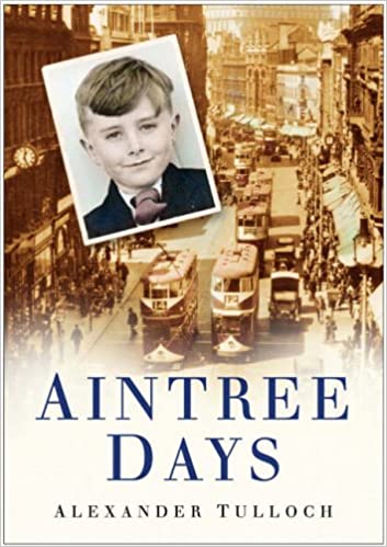
Book: Aintree Days, by Alexander Tulloch. There are few books on Aintree history that don't talk exclusively about racing of one sort or another, but given Alexander Tulloch's other books on Liverpool, this should be a good read.
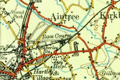
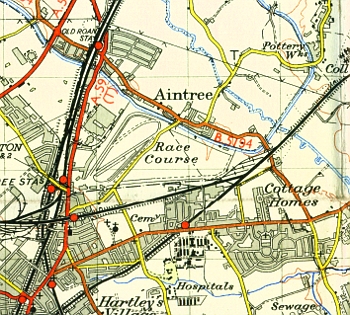
Aintree as a village
Use the slider in the top left to change the transparency of the old map.
Tiny Beginnings, Industrial Expansion
Aintree's great advantages for industry are its landscape and location. Factories could expand across the flat open land, attracting more and more workers. Housing could be built in huge chunks so workers could live close by. Products from the factories moved quickly to Liverpool and its docks. Even the military realised the possibilities, and sited one of the Royal Ordnance Factories here in the 1930s.
So from the late 19th century until to the Second World War, Aintree expanded at a phenomenal rate. In the later twentieth century, more 'clean air' industries joined the growth. Food processing, electrical engineering and printing were all close by, along with similar sites growing in Speke. By 1952, 24 factories employed 12,800 people, as part of a post-war move to re-allocate Britain's industrial resources.
Horses and Cars at Aintree Racecourse
The more recent history of Aintree is inseparable from the racecourse and the Grand National. Horse racing was a popular sport in Liverpool from at least Tudor times. In the 18th century Nicholas Blundell organised races on the sands at Crosby and the Derby was run here in 1780. William Lynn, landlord of the Waterloo Hotel in Aintree, created a racetrack close to his own pub in 1829. In 1836 he opened a new grand stand, and then organised a four mile steeplechase, won that year by Captain Beecher on 'Duke'. Some researchers prefer to think of this race as the first true Grand National.
By 1839 the aristocracy took an interest, and Lords Derby, Eglington, Wilton and Sefton and Lord George Bentinck backed a national racing event. Fifty thousand people crowded into the event, and so the race was dubbed the 'Grand National' by a journalist. The label came into common use, and in 1847 became official.
But it's not only horses which have raced around Aintree. The British Grand Prix came to Liverpool five times between 1955 and 1962, and in 1953 Stirling Moss became the first Briton to win it. Car racing finally came to an end at Aintree in the early 1980s.
From an acorn ain mighty oak

Domesday Book makes no mention of Aintree. It was a small part of West Derby, and came under that place's entry.
The flat and featureless place may have gained it the name 'One Tree [and little else!]'. But once people drained the boggy land and industries moved in, the landscape worked in its favour. The proximity of Liverpool was the perfect way to transport goods to market, and companies flocked to take advantage of the open space and growing workforce.
Aintree is known to racing fans and the wider public for its steeplechase. But for almost as long the village has been the centre of an industrial tradition which carries on today.
Bibliography
- History, Aintree Village Parish Council, retrieved 3rd August 2014
- History of S Giles Church, Parish Church of St. Giles, retrieved 3rd December 2009
Mapping the history of Liverpool
Old maps, interactive maps and the historic landscape of Merseyside.
Buy maps
Many of the maps on this site can be bought as high quality prints, either as paper or ready-framed.
You can also buy notebooks, postcards, greetings cards and other map-printed items!
Go to the shop to find out more
The book
Liverpool: a landscape history is a book about Liverpool and Merseyside from the very earliest days to the 21st century.
You’ll learn about everything from the Calderstones to the Capital of Culture.
Signed copies are available direct from me, the author, in the shop.
#ads

A set of three matching Cassini maps from three different periods, designed to appeal to anyone who wants to discover the hidden history of their local landscape.
- Cassini Old Series Maps first published between 1805 and 1874
- Cassini Revised New Series Maps first published between 1896 and 1904
- Cassini Popular Edition Maps first published between 1919 and 1926
Leave a comment
Peter Gill
08/02/2014 21:17:27
Many thanks,
Peter
Cllr Peter Gill
Chairman Aintree Village Parish Council
Reply to Peter Gill
Martin Greaney
08/03/2014 22:32:42
Thanks for pointing out the dead link! I've replaced it with the link you've supplied, so hopefully readers will be able to more easily find their way to your history pages.
Regards,
Martin
Reply to Martin Greaney
DAVID LYNCH
09/20/2022 16:30:38
Reply to DAVID LYNCH
Peter Gill
10/11/2014 22:59:17
Reply to Peter Gill
DAVID LYNCH
09/20/2022 16:31:47
Reply to DAVID LYNCH
Peter Heney
12/03/2022 09:25:32
Reply to Peter Heney
Martin Greaney
12/16/2022 08:23:17
Looking at the old maps, I can't see any water course through the village itself. There's only the Leeds-Liverpool Canal to the south and the stream to the north which still runs under Bull Bridge Lane / Spencers Lane.
Best wishes,
Martin
Reply to Martin Greaney
Peter Gill
06/20/2023 09:02:48
The stream you are talking about is the River Alt and that marks the north boundary of the Civil Parish of Aintree Village. It rises in Huyton and runs up to Formby and then down to Hightown and out into Liverpool Bay.
This is the new address for the parish council.
https://aintreevillageparishcouncil.gov.uk/
Reply to Peter Gill
Martin Greaney
09/18/2023 21:37:53
I've updated the screenshot with the new site. Looks great!
Cheers,
Martin
Reply to Martin Greaney
Paul Higgins
08/26/2025 14:28:02
The latter was supposed to have been the Kennels for Lord Sefton's hounds.
Reply to Paul Higgins