This is part of a series of posts based on the talks given at the Recent Developments in Merseyside Archaeology conference. It was held on the 13th October 2018, and took place at the Museum of Liverpool. It’s based on a talk given by Ron Cowell, who has excavated at Lunt Meadows for a few years now.
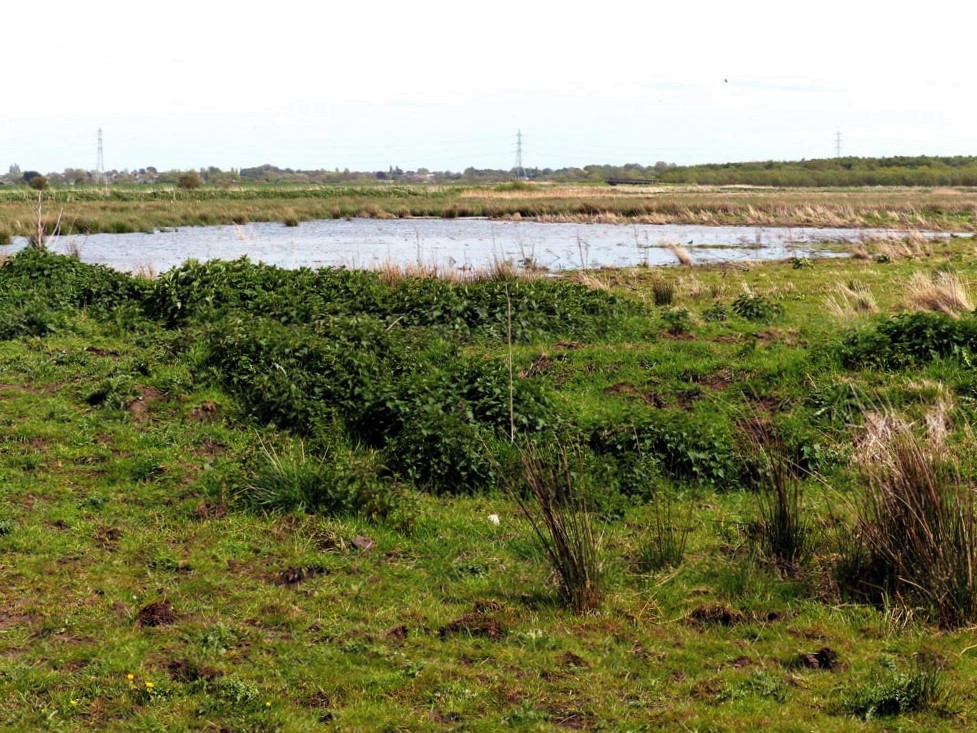
The project started in 2012, because the Environment Agency (EA) were working in this area between Maghull and Crosby to restore the reed beds. and ponds for conservation reasons.
The excavations looked at 12,000 year-old deposits around the River Alt, but showed the potential for other sites to be found in the area in the future. Marine clay sits on top of freshwater clay (showing a change in the environment over time), which in turn sits on top of the Mesolithic occupation layer. During the time people inhabited this area, the ground was initially drier than it would be later on.
The lack of drainage on this wet site has led to good preservation of artefacts and structural evidence. The archaeology is also deep enough that it’s not been damaged by ploughing.
Discoveries
The team found a floor surface surrounded by a ring of postholes. The small size of the holes suggests the poles (and hence the walls) were short, with any roof coming close to the ground. Stone tools were found too. These would have been used for building the shelter, gathering food, and making clothes. These people would not have farmed. The tools date different elements of the site to between 9,500 to 6,000 years ago, with repeat visits and re-use over this time.
The tools were made of flint from the local area, and chert. It became apparent that the chert was not from nearby. Another site excavated in the region, Greasby, brought up chert tools made of stone from North Wales, but this was different. Its appearance is more like that of chert from the Clitheroe area.
Hut circles in the landscape
It looks from the plans as if there are two hut circles, each with two ditches. Despite their closeness to each other, they might be as much as 200 years apart (9,300 and 9,100 years ago respectively), and were occupied by groups doing all kinds of different things. Their activities would have depended on the season, and the size of the groups would vary. Perhaps the different groups were related, a series of generations visiting the same site year after year (or decade after decade).
The area around the huts, now wetlands, would have been oak and hazel forest. Ron noted that the position of the trees was as much a part of the site as the placing of the huts. The Alt itself would have been further away from the site 9,000 years ago, although closer 7.500 years ago. It seems that no archaeology has been found from this period over 4m above sea level. This was the flood plain, and Mesolithic communities were intentionally building on the flood plain, and nowhere else.
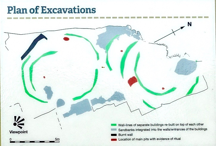
One of the most interesting sets of finds represented what Ron called ‘formal symbolic acts’. Melon-sized granite boulders – the granite having sparkling mica pieces in – were deliberately placed in the ground. These large stones were stained red by sitting in iron rich soils, and this may have contributed to their importance to the Mesolithic people here. Next to these boulders – there were two similar ones on the site – were struck blue flints and a smaller pebble. There were two of these flint-pebble pairs at each granite boulder, placed on opposite sides of the central stone. What these arrangements might have ‘meant’ is unknown, but it shows that life was more than mere utilitarian survival. Time was spent on activities whose meaning we can’t intuit.
Later history of Lunt Meadows
The later phases of the site have been dated to 7,900 years ago. At this time a tree was deliberately set alight on the site. It’s trunk now lies on its side in the excavated area, and a white flint blade placed deliberately beneath it. The significance of the tree burning has been lost to us.
By around 7,500 years ago the oak and hazel forest was dying back due to a rising sea level and water table. The area became a fen and swamp, before settling into a reed swamp about 7,500 years ago. It’s this reed swamp landscape that the Environment Agency are restoring. Essentially, Lunt Meadows is once again a prehistoric wetland landscape!
Future of the project
Ron Cowell continues to excavate at Lunt Meadows, and in fact the archaeological site is now part of the nature reserve. The Environment Agency have agreed to incorporate the archaeology into their project, reflecting on and demonstrating how humans and nature can co-exist in a way that leaves both richer for it. It’s an active site with Key Stage 2 school children visiting regularly. The Stone Age is part of KS2 these days, so Lunt Meadows provides a great resource. The Young Archaeologist Club have also visited, and built a ‘Mesolithic’ hut with reeds that they had themselves cut.
A case is ready in the Museum of Liverpool to house objects from the excavation, and at the time of writing this should be ready for visitors at the end of October 2018.
An app (for phones and tablets) has been developed by a company called Inspyro, which takes advantage of new Augmented Reality (AR) technology. With the app installed, a person can explore the Lunt Meadows landscape by overlaying it on the scene in front of them (as seen through the camera on the device). This works best at the site itself, to recreate the Mesolithic landscape and walk among it. But the app also works on smaller scales – you can project a miniature Mesolithic world onto your tabletop! This app is still in production, and so the version you can install today will be getting updates and become more advanced as time goes on. You can already listen to Ron narrating the introduction, and look through a couple of different scenes.
More information
Lunt Meadows Mesolithic Settlement, Merseyside: A Site for Sore Eyes, Day of Archaeology, retrieved 22nd October 2018
Conjuring lost lives from the sands of Lunt Meadows, That’s How the Light Gets In, retrieved 22nd October 2018
keith bentham
says:My mums cousin was married to a farmer at Bickerstaffe. Whilst digging ditches in the 1970s ( draining land )he dug down about 10 feet and found an old stream bed. He found a mesolithic bow and arrows and a stone age axe (he gave to a local school). The bow disintegrated on contact with air as did the arrows. I later found myself a shell with perforated hole that I still have at Mossborough Hall where I beleive there was a neolithic barrow.
sheila McGuinness
says:Is there anyone managing the Neolithic site in Lunt who can explain the area , its function etc, and is there anything for people to see ?? We ha e a U3A History group. who we try to take to local areas of interest, and I thought this had a story behind it of some interest to them.We are thinking of April 7th 2022???
Sheila McGuinness U3A history group Formby. Many thanks for any ad ice or help.
Contact 0151 526 4281
or email sheila.mac@blueyonder.co.uk